Файл:Dixon entrance boundary dispute.jpg
Перейти к навигации
Перейти к поиску
Размер этого предпросмотра: 800 × 431 пкс. Другие разрешения: 320 × 173 пкс | 640 × 345 пкс | 1280 × 690 пкс.
Исходный файл (1280 × 690 пкс, размер файла: 117 Кб, MIME-тип: image/jpeg)
Этот файл находится на Викискладе. Сведения о нём показаны ниже.
Викисклад — централизованное хранилище для свободных файлов, используемых в проектах Викимедиа.
|
Краткое описание
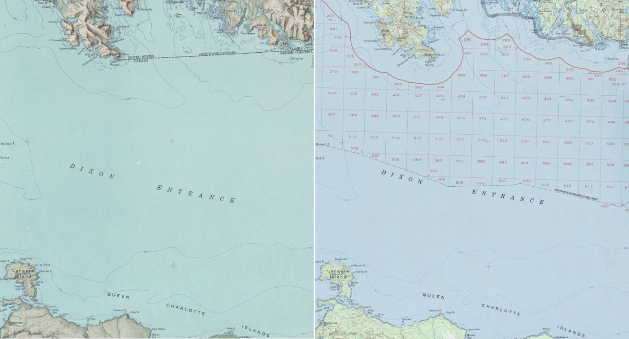
| Описание | Dixon Entrance, Northwestern America. An illustration of the boundary dispute by showing the different notions of the U.S.-Canadian boundary on two maps provided by the U.S. Dept. of the Interior Geological Survey (enlarged detail of original material). The left side shows the 1903 AB-Line (dashed line in the upper third) and the right side the U.S. notion of the “limit of exclusive economic zone” (dashed black line near the label ‘Dixon Entrance’). |
| Дата | |
| Источник | Both source maps are from the US Geological Survey 1:250,000 series of Alaska; available online at the University of Texas Perry-Castañeda Library Map Collection 1959 map (jpg 3.4 MB) 1985 map (jpg 5.4 MB) |
| Автор | Carsten Finis |
| Права (Повторное использование этого файла) |
Source Material: http://www.lib.utexas.edu/maps/faq.html#3.html |
Лицензирование
Это произведение находится в общественном достоянии (англ. public domain) в Соединённых Штатах Америки, так как оно является работой, выполненной должностным лицом или наёмным сотрудником Федерального правительства США в качестве части служебных обязанностей этого лица. Правовой статус регламентируется в соответствии с разделом 17, главой 1, секцией 105 Кодекса Соединённых Штатов. См. Авторское право.
Обратите внимание: это относится только к оригинальным (первоначальным) произведениям Федерального правительства, а не к произведениям любого отдельного штата США, территории, содружества, округа, муниципалитета или любой другой территориальной единицы. Этот шаблон также не относится к дизайну почтовых марок, изданных Почтовой службой США с 1978 года. (См. § 313.6(C)(1) в Compendium of U.S. Copyright Office Practices). Это также не относится к определённым монетам США; см. Условия использования Монетного двора США.
|
 | |
| Этот файл был определён как свободный от известных ограничений авторского права, а также связанных и смежных прав. | ||
История файла
Нажмите на дату/время, чтобы посмотреть файл, который был загружен в тот момент.
| Дата/время | Миниатюра | Размеры | Участник | Примечание | |
|---|---|---|---|---|---|
| текущий | 22:39, 30 ноября 2007 | | 1280 × 690 (117 Кб) | Pyrokrat~commonswiki | {{Information |Description=Dixon Entrance, Northwestern America. An illustration of the boundary dispute by showing the different notions of the U.S.-Canadian boundary on two maps provided by the U.S. Dept. of the Interior Geological Survey (enlarged deta |
Использование файла
Следующая страница использует этот файл:
Глобальное использование файла
Данный файл используется в следующих вики:
- Использование в ar.wikipedia.org
- Использование в de.wikipedia.org
- Использование в en.wikipedia.org
- Использование в es.wikipedia.org