Файл:NorthAmerica-WaterDivides.png
Перейти к навигации
Перейти к поиску

Размер этого предпросмотра: 600 × 600 пкс. Другие разрешения: 240 × 240 пкс | 480 × 480 пкс | 900 × 900 пкс.
Исходный файл (900 × 900 пкс, размер файла: 370 Кб, MIME-тип: image/png)
Этот файл находится на Викискладе. Сведения о нём показаны ниже.
Викисклад — централизованное хранилище для свободных файлов, используемых в проектах Викимедиа.
|
Краткое описание
| Описание |
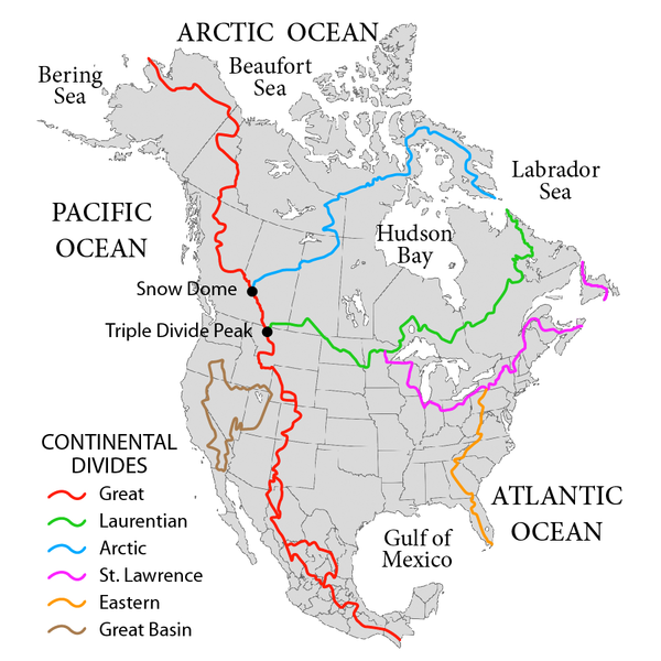
English: Map showing the major Continental divides of North America, following the style of File:NorthAmericaDivides.gif and intended as a replacement. Made using File:BlankMap-North America-Subdivisions.svg as a base map. Various maps and other sources consulted, such as: File:Ocean drainage.png, Drainage Basins, The Atlas of Canada, http://www.cec.org/atlas/files/watersheds/na_watersheds_en.jpg, and others. Note: the Eastern watershed boundary in the southern areas (orange line), and the St. Lawrence watershed boundary in the northern areas (magenta line) of this map more or less defined the Royal Proclamation's western boundaries. |
| Дата | |
| Источник | Собственная работа |
| Автор | Pfly |
Лицензирование
Я, владелец авторских прав на это произведение, добровольно публикую его на условиях следующих лицензий:
Этот файл доступен по лицензии Creative Commons Attribution-Share Alike 3.0 Unported.
- Вы можете свободно:
- делиться произведением – копировать, распространять и передавать данное произведение
- создавать производные – переделывать данное произведение
- При соблюдении следующих условий:
- атрибуция – Вы должны указать авторство, предоставить ссылку на лицензию и указать, внёс ли автор какие-либо изменения. Это можно сделать любым разумным способом, но не создавая впечатление, что лицензиат поддерживает вас или использование вами данного произведения.
- распространение на тех же условиях – Если вы изменяете, преобразуете или создаёте иное произведение на основе данного, то обязаны использовать лицензию исходного произведения или лицензию, совместимую с исходной.

|
Разрешается копировать, распространять и/или изменять этот документ в соответствии с условиями GNU Free Documentation License версии 1.2 или более поздней, опубликованной Фондом свободного программного обеспечения, без неизменяемых разделов, без текстов, помещаемых на первой и последней обложке. Копия лицензии включена в раздел, озаглавленный GNU Free Documentation License. |
Вы можете выбрать любую из этих лицензий.
История файла
Нажмите на дату/время, чтобы посмотреть файл, который был загружен в тот момент.
| Дата/время | Миниатюра | Размеры | Участник | Примечание | |
|---|---|---|---|---|---|
| текущий | 02:47, 1 октября 2019 | | 900 × 900 (370 Кб) | Palaeozoic99 | Correct St. Lawrence |
| 07:12, 22 ноября 2018 |  | 900 × 900 (440 Кб) | Pfly | Try to remove transparency one more time, sigh | |
| 06:51, 22 ноября 2018 |  | 900 × 900 (290 Кб) | Pfly | Reverting to original with non-transparent background, as the transparency was displaying very badly, even unreadably, on mobile devices | |
| 06:49, 22 ноября 2018 |  | 900 × 900 (256 Кб) | Pfly | revert my own reversion--made mistake | |
| 06:44, 22 ноября 2018 |  | 900 × 900 (290 Кб) | Pfly | Reverted to version as of 21:09, 23 November 2010 (UTC): Transparent background looks very bad, even unreadable on mobile. | |
| 02:46, 15 июля 2012 |  | 900 × 900 (256 Кб) | Ubiquinoid | mildly updated: including names of oceans/seas in vicinity of North America (as displayed), per IHO | |
| 02:43, 15 июля 2012 |  | 900 × 900 (256 Кб) | Ubiquinoid | mildly updated: including names of oceans/seas in vicinity of North America (as displayed), per IHO | |
| 21:09, 23 ноября 2010 |  | 900 × 900 (290 Кб) | Pfly | {{Information |Description={{en|1=Map showing the major Continental divides of North America, following the style of File:NorthAmericaDivides.gif and intended as a replacement. Made using [[:File:BlankMap-North America-Subd |
Использование файла
Следующие 2 страницы используют этот файл:
Глобальное использование файла
Данный файл используется в следующих вики:
- Использование в ar.wikipedia.org
- Использование в cs.wikipedia.org
- Использование в de.wikipedia.org
- Использование в en.wikipedia.org
- North America
- List of rivers of the Americas
- Royal Proclamation of 1763
- Continental Divide of the Americas
- Rupert's Land
- Pigeon River (Minnesota–Ontario)
- Atlantic seaboard watershed
- Eastern Continental Divide
- Talk:Kensington Runestone
- Talk:List of lighthouses in the United States
- Great Divide Basin
- Central United States
- Triple Divide Peak (Montana)
- Chicago Portage
- Snow Dome (Canada)
- Hudson Bay drainage basin
- Geography of North America
- Laurentian Divide
- Continental divide
- Great Basin Divide
- Watersheds of North America
- Canadian canoe routes
- Voyageurs
- Pacific Slope
- Centennial Voyageur Canoe Pageant
- Triple divide
- St. Lawrence River Divide
- Timeline of Alberta history
- Использование в en.wiktionary.org
- Использование в eo.wikipedia.org
- Использование в es.wikipedia.org
- Использование в fr.wikipedia.org
- Использование в hr.wikipedia.org
- Использование в id.wikipedia.org
- Использование в ig.wikipedia.org
- Использование в it.wikipedia.org
Просмотреть глобальное использование этого файла.