Файл:Upsala Glacier, Argentina.jpg
Исходный файл (4288 × 2848 пкс, размер файла: 4,91 Мб, MIME-тип: image/jpeg)
Этот файл находится на Викискладе. Сведения о нём показаны ниже.
Викисклад — централизованное хранилище для свободных файлов, используемых в проектах Викимедиа.
|
Краткое описание
| Описание |
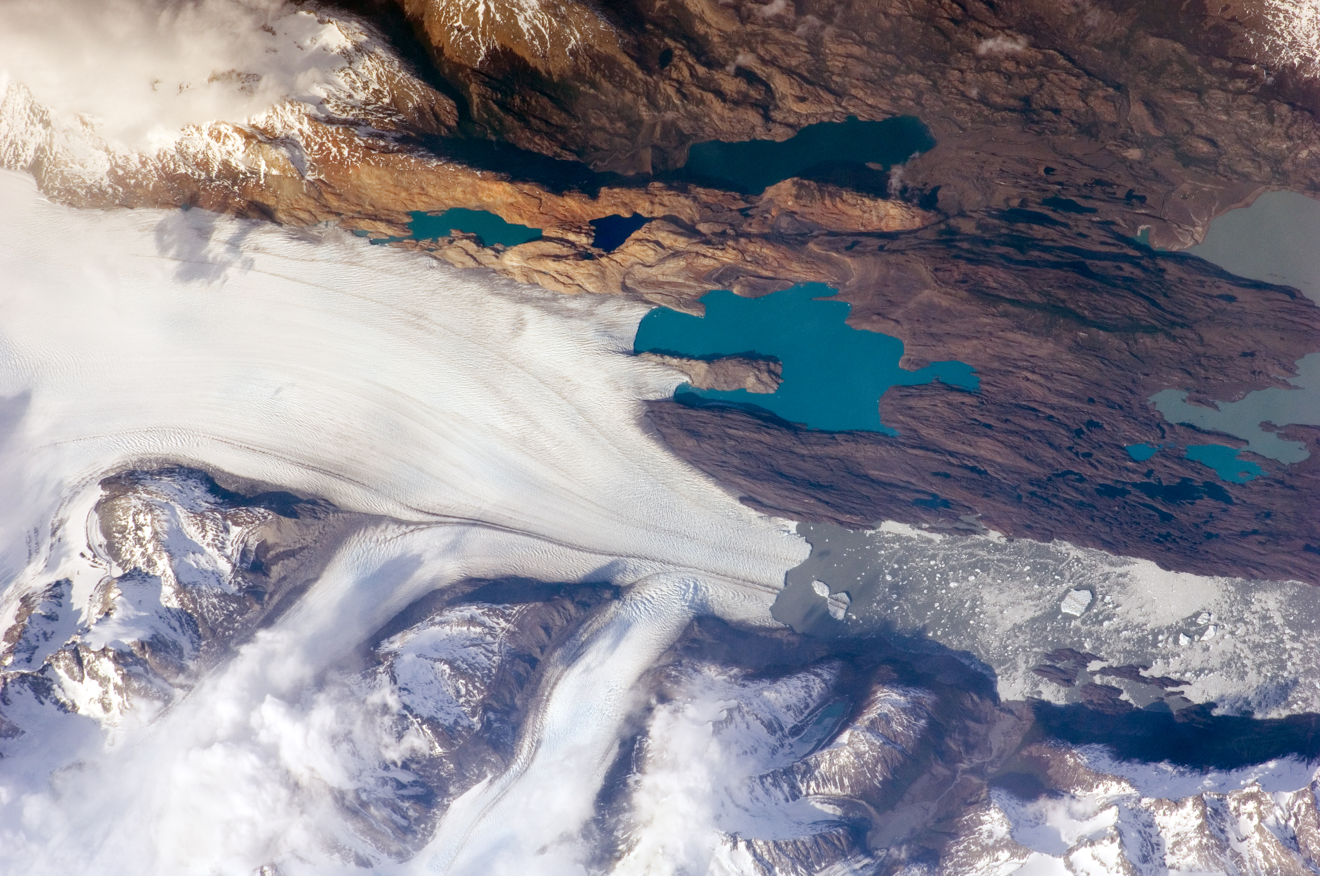
English: The Southern Patagonian Icefield of Argentina and Chile is the southern remnant of the Patagonia Ice Sheet that covered the southern Andes Mountains during the last ice age. This detailed astronaut photograph illustrates the terminus of one of the ice-field’s many spectacular glaciers—Upsala Glacier, located on the eastern side of the ice-field.
This image was taken during spring in the Southern Hemisphere, and icebergs were calving from the glacier terminus into the waters of Lago Argentino (Lake Argentina, image right). Two icebergs are especially interesting because they retain fragments of the moraine (rock debris) that forms a dark line along the upper surface of the glacier. The inclusion of the moraine illustrates how land-based rocks and sediment may wind up in ocean sediments far from shore. Moraines are formed from rock and soil debris that accumulate along the front and sides of a flowing glacier. The glacier is like a bulldozer that pushes soil and rock in front of it, leaving debris on either side. When two glaciers merge (image centre), moraines along their edges can join to form a medial moraine that is drawn out along the upper surface of the new glacier. |
| Дата | Снято: 25 октября 2009 |
| Источник | NASA Earth Observatory |
| Автор |
This image was taken by the NASA Expedition 21 crew
|
| Местоположение камеры | | Это и другие изображения по их местоположению на OpenStreetMap |
|---|
|
Это изображение или видеозапись внесены в каталог Космического центра имени Джонсона НАСА под идентификатором (Photo ID): ISS021-E-15243. Этот шаблон не указывает на правовой статус данной работы. По-прежнему необходим нормальный шаблон лицензий. См. Commons:Лицензирование. Другие языки:
|
Лицензирование
This file is in the public domain in the United States because it was created by the Image Science & Analysis Laboratory, of the NASA Johnson Space Center. NASA copyright policy states that "NASA material is not protected by copyright unless noted". (NASA media use guidelines or Conditions of Use of Astronaut Photographs).
Photo source: ISS021-E-15243.
|
| Аннотации | Это изображение аннотировано: Просмотреть аннотации на Викискладе |
История файла
Нажмите на дату/время, чтобы посмотреть файл, который был загружен в тот момент.
| Дата/время | Миниатюра | Размеры | Участник | Примечание | |
|---|---|---|---|---|---|
| текущий | 17:13, 3 февраля 2017 | | 4288 × 2848 (4,91 Мб) | Ras67 | new rendered in high quality from NASA's raw image data (with 5500 K) |
| 09:32, 9 июня 2010 |  | 3072 × 2032 (5,45 Мб) | Originalwana | higher res | |
| 11:01, 17 ноября 2009 |  | 1440 × 960 (942 Кб) | Originalwana | {{Information |Description={{en|1=The Southern Patagonian Icefield of Argentina and Chile is the southern remnant of the Patagonia Ice Sheet that covered the southern Andes Mountains during the last ice age. This detailed |
Использование файла
Следующие 3 страницы используют этот файл:
Глобальное использование файла
Данный файл используется в следующих вики:
- Использование в ast.wikipedia.org
- Использование в be.wikipedia.org
- Использование в bn.wikibooks.org
- Использование в bs.wikipedia.org
- Использование в cs.wikipedia.org
- Использование в de.wikipedia.org
- Использование в en.wikipedia.org
- Использование в en.wikiversity.org
- Использование в eo.wikipedia.org
- Использование в es.wikipedia.org
- Использование в fa.wikibooks.org
- Использование в fr.wikipedia.org
- Использование в he.wikipedia.org
- Использование в hr.wikipedia.org
- Использование в hy.wikibooks.org
- Использование в it.wikibooks.org
- Использование в it.wikiversity.org
- Использование в ko.wikipedia.org
- Использование в pl.wikipedia.org
- Использование в sh.wikipedia.org
- Использование в sl.wikipedia.org
- Использование в sv.wikipedia.org
- Использование в ta.wikipedia.org
- Использование в uk.wikipedia.org