Файл:1852 Andrews Map of Florida, Cuba and the Gulf of Mexico - Geographicus - StraitsofFlorida-andrews-1852.jpg

Исходный файл (5000 × 3977 пкс, размер файла: 1,43 МБ, MIME-тип: image/jpeg)
Этот файл находится на Викискладе. Сведения о нём показаны ниже.
Викисклад — централизованное хранилище для свободных файлов, используемых в проектах Викимедиа.
|
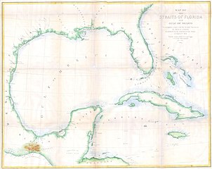
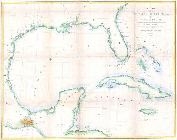
| Map of the Straits of Florida and Gulf of Mexico. To accompany a report from the Treasury Department of Israel D. Andrews in obedience to the resolution of the Senate of March 8th, 1851. | ||||||
|---|---|---|---|---|---|---|
| Автор | ||||||
| Название |
Map of the Straits of Florida and Gulf of Mexico. To accompany a report from the Treasury Department of Israel D. Andrews in obedience to the resolution of the Senate of March 8th, 1851. |
|||||
| Описание |
English: This is a rare large format costal chart depicting the full coast of the Gulf of Mexico, Florida, the Bahamas, The Isthmus of Tehuantepec, Yucatan, Cuba and Jamaica. It was issued in 1852 to accompany Israel D. Andrews’ report to the Senate. Depicts coastal cities and ports, offshore shoals, knolls, reefs, banks and other nautical hazards and some inland details, especially in the important overland crossing from Atlantic to Pacific of Tehuantepec, Mexico. Contemporary hand color. Andrews was the Consul of the United States for Canada and Trade and Commerce. U.S. Coastal Survey. Prepared under A. D. Bache. Publisher: The Office of the Coast Survey, founded in 1807 by Secretary of Commerce Albert Gallatin and President Thomas Jefferson, is the oldest organization of its kind in the U.S. Federal Government. The hard working and daring agents of the U.S. Coast Survey were the first explorers to accurately map the North American coast line, opening the ports of the west to trading vessels from Europe, America and Asia. Gallatin chose Swiss immigrant and West Point mathematics professor Ferdinand Hassler to direct the Coast Survey. Under the direction of Hassler, the Coast Survey developed a reputation for uncompromising dedication to the principles of accuracy and excellence. Hassler lead the Coast Survey until his death in 1843, at which time Alexander Dallas Bache, a great-grandson of Benjamin Franklin, took the helm. Under the leadership A. D. Bache, the Coast Survey did most of its most important work. During his Superintendence, Bache was steadfast advocate of American science and navigation and in fact founded the American Academy of Sciences. The techniques developed by the United States Coast Survey were later used by the U.S. Geological and Geodetic Survey in the late 19th and early 20th century. |
|||||
| Дата | 1852 | |||||
| Размеры | высота: 27,5 дюймов (69,8 см); ширина: 34 дюймов (86,3 см) | |||||
| Инвентарный номер |
Geographicus link: StraitsofFlorida-andrews-1852 |
|||||
| Источник/Фотограф |
|
|||||
| Права (Повторное использование этого файла) |
|
|||||
История файла
Нажмите на дату/время, чтобы посмотреть файл, который был загружен в тот момент.
| Дата/время | Миниатюра | Размеры | Участник | Примечание | |
|---|---|---|---|---|---|
| текущий | 11:55, 24 марта 2011 | | 5000 × 3977 (1,43 МБ) | BotMultichillT | {{subst:User:Multichill/Geographicus |link=http://www.geographicus.com/P/AntiqueMap/StraitsofFlorida-andrews-1852 |product_name=1852 Andrews Map of Florida, Cuba and the Gulf of Mexico |map_title=Map of the Straits of Florida and Gulf of Mexico. To accom |
Использование файла
Следующая страница использует этот файл:
Глобальное использование файла
Данный файл используется в следующих вики:
- Использование в en.wikipedia.org