Файл:Geo Map of Median Income by Location in Tennessee.png
Перейти к навигации
Перейти к поиску

Размер этого предпросмотра: 800 × 406 пкс. Другие разрешения: 320 × 162 пкс | 640 × 325 пкс | 1024 × 520 пкс | 1738 × 882 пкс.
Исходный файл (1738 × 882 пкс, размер файла: 603 КБ, MIME-тип: image/png)
Этот файл находится на Викискладе. Сведения о нём показаны ниже.
Викисклад — централизованное хранилище для свободных файлов, используемых в проектах Викимедиа.
|
Краткое описание
| Описание |
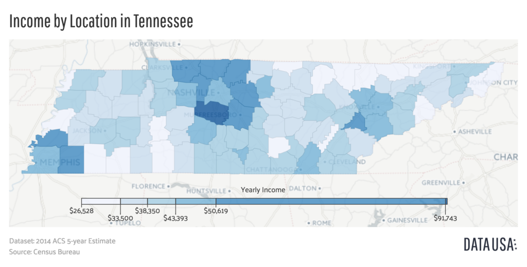
English: A geomap showing the counties of Tennessee colored by the relative range of that county's median income. Data is sourced from the 2014 ACS 5-year Estimate Report put out by the US Census Bureau |
| Дата | |
| Источник | http://datausa.io/profile/geo/tennessee/#income_geo |
| Автор | Datawheel, LLC |
Лицензирование

|
This work is free software; you can redistribute it and/or modify it under the terms of the GNU Affero General Public License as published by the Free Software Foundation; either version 3 of the License, or any later version. This work is distributed in the hope that it will be useful, but without any warranty; without even the implied warranty of merchantability or fitness for a particular purpose. See version 3 of the GNU Affero General Public License for more details.
|
История файла
Нажмите на дату/время, чтобы посмотреть файл, который был загружен в тот момент.
| Дата/время | Миниатюра | Размеры | Участник | Примечание | |
|---|---|---|---|---|---|
| текущий | 20:31, 3 августа 2016 | | 1738 × 882 (603 КБ) | Mattrdini | User created page with UploadWizard |
Использование файла
Следующая страница использует этот файл:
Глобальное использование файла
Данный файл используется в следующих вики:
- Использование в en.wikipedia.org
- Использование в fa.wikipedia.org
- Использование в vi.wikipedia.org
- Использование в zh.wikipedia.org