Файл:Golan heights rel89B.jpg
Перейти к навигации
Перейти к поиску

Размер этого предпросмотра: 468 × 599 пкс. Другие разрешения: 187 × 240 пкс | 375 × 480 пкс | 1022 × 1308 пкс.
Исходный файл (1022 × 1308 пкс, размер файла: 231 КБ, MIME-тип: image/jpeg)
Этот файл находится на Викискладе. Сведения о нём показаны ниже.
Викисклад — централизованное хранилище для свободных файлов, используемых в проектах Викимедиа.
|
Краткое описание
| Описание |
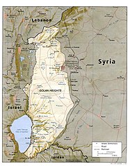
English: I created this image myself, by modifying the existing Image:Golan_heights_rel89A.jpg, which was itself a modified version of a modified CIA (and hence public domain) Image:Golan_92.jpg. Previous modifications were done to provide a map that was impartial about the contentious issue of which country owns the Golan Heights. The previous modifications were effective in creating a neutral map by removing the names "Syria" and "Israel" from the contentious territory and left only the label "Golan Heights". The present modification was intended solely to restore the names and locations of villages that were included on the original CIA map but had been (inadvertently) moved or erased by relocating the country titles. Due to the recurrent conflict involving villages and settlements within the Golan Heights, I feel that it is important to retain the locations on the map. As with the earlier modifications of this file, I hope that this modification will be seen as a fair compromise that also maintains the cartographical accuracy of map. I make no copyright claim on my modification; its copyright status is the same as its source. dp_roberson 15:44, 21 October 2007 (UTC) |
| Дата | 21 сентября 2007 (дата первоначальной загрузки файла на вики) |
| Источник | Перенесено с en.wikipedia на Викисклад. |
| Автор | Dp roberson из английский Википедия |
Лицензирование
| Автор этого произведения, Dp roberson из английский Википедия, передаёт его в общественное достояние. Это разрешение действует по всему миру. В некоторых странах это не может быть возможно юридически, в таком случае: Dp roberson предоставляет любому право использовать данное произведение в любых целях, без каких-либо условий, если только такие условия не требуются по закону. |
Исходный журнал загрузок
Первоначальная страница описания находилась здесь. Все нижеперечисленные имена участников относятся к en.wikipedia.
- 2008-12-29 03:13 كهيعص 1022×1308× (236080 bytes) added 4 villages to the map
- 2007-09-21 15:45 Dp roberson 1022×1308× (226330 bytes) I created this image myself, by modifying the existing Image:Golan_heights_rel89A.jpg, which was itself a modified version of a modified CIA (and hence public domain) Image:Golan_92.jpg. Previous modifications were done to provide a map that was impartia
История файла
Нажмите на дату/время, чтобы посмотреть файл, который был загружен в тот момент.
| Дата/время | Миниатюра | Размеры | Участник | Примечание | |
|---|---|---|---|---|---|
| текущий | 04:56, 27 января 2015 | | 1022 × 1308 (231 КБ) | Magog the Ogre | Reverted to version as of 22:56, 25 January 2015 |
| 22:56, 25 января 2015 |  | 468 × 599 (257 КБ) | OgreBot | (BOT): Reverting to most recent version before archival | |
| 22:56, 25 января 2015 |  | 1022 × 1308 (231 КБ) | OgreBot | (BOT): Uploading old version of file from en.wikipedia; originally uploaded on 2008-12-29 03:13:42 by كهيعص | |
| 13:20, 22 сентября 2010 |  | 468 × 599 (257 КБ) | Ravpapa | Added the words "(Israeli occupied)" under the words "Golan Heights". This makes it clear that the area is occupied. | |
| 08:53, 5 марта 2008 |  | 1022 × 1308 (221 КБ) | Cansado | {{Information |Description={{en|I created this image myself, by modifying the existing Image:Golan_heights_rel89A.jpg, which was itself a modified version of a modified CIA (and hence public domain) Image:Golan_92.jpg. Previous modifications were done to |
Использование файла
Следующая страница использует этот файл:
Глобальное использование файла
Данный файл используется в следующих вики:
- Использование в ar.wikipedia.org
- Использование в ba.wikipedia.org
- Использование в de.wikinews.org
- Использование в en.wikipedia.org
- Использование в tr.wikipedia.org