Файл:SDBayAreaNASA.jpg
Перейти к навигации
Перейти к поиску

Размер этого предпросмотра: 600 × 600 пкс. Другие разрешения: 240 × 240 пкс | 480 × 480 пкс | 768 × 768 пкс | 1024 × 1024 пкс | 2048 × 2048 пкс | 4055 × 4055 пкс.
Исходный файл (4055 × 4055 пкс, размер файла: 13,45 МБ, MIME-тип: image/jpeg)
Этот файл находится на Викискладе. Сведения о нём показаны ниже.
Викисклад — централизованное хранилище для свободных файлов, используемых в проектах Викимедиа.
|
Краткое описание
| Описание |
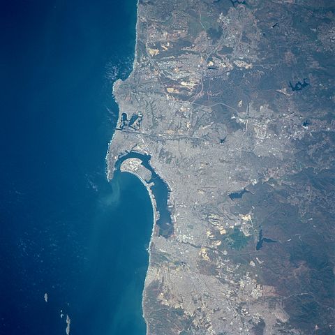
English: Three major features dominate this image of the southwest coast of California: the deep blue (dark) waters of the Pacific Ocean; the highly reflective, man-made urban and suburban environment along the coast; and the rugged, natural terrain of low mountain foothills of the Peninsular Ranges east of the urban development. The greater metropolitan area of San Diego (CA) and Tijuana (Mexico) with a combined population of approximately four million people can be identified as the lighter colored, highly reflective area on the image. Several types of infrastructure associated with the developed urban area are visible on this small-scale image. Reservoirs, including the lower Otay, Sweetwater, and St. Vicente Reservoirs, are the irregularly shaped, dark blue areas. The light-colored linear runways of Miramar Naval Air Station lie north of the densely populated area of San Diego. Interstate Highways 5 and 15 (light colored, linear features) radiate northward away from San Diego. The small square-shaped features along the edges of the bay are the many piers that jut into San Diego Bay. Mission Bay Harbor and Marina (dark area) is found along the coast north of the entrance to San Diego Bay. |
| Дата | 20 апреля 1998, 19:45:12 UTC |
| Источник | Image courtesy of Earth Sciences and Image Analysis Laboratory, NASA Johnson Space Center: NASA photo STS090-758-17 (mission STS090, roll 758, frame 17); high-resolution version from ftp://eol.jsc.nasa.gov/EFS_highres_STS090_STS090-758-17.JPG |
| Автор | NASA |
| Местоположение камеры | | Это и другие изображения по их местоположению на OpenStreetMap |
|---|
Лицензирование
| Этот файл находится в общественном достоянии (англ. public domain), так как он был создан NASA (Национальным управлением по аэронавтике и исследованию космического пространства). Политика авторского права NASA гласит, что «Материал NASA не защищается авторским правом, если не указано иное». (См. Template:PD-USGov, страницу политики авторского права NASA или политику использования изображений JPL.) | ||
 |
Предупреждения:
|
| Аннотации | Это изображение аннотировано: Просмотреть аннотации на Викискладе |
История файла
Нажмите на дату/время, чтобы посмотреть файл, который был загружен в тот момент.
| Дата/время | Миниатюра | Размеры | Участник | Примечание | |
|---|---|---|---|---|---|
| текущий | 22:24, 30 июня 2012 | | 4055 × 4055 (13,45 МБ) | Closeapple | high-resolution version from ftp://eol.jsc.nasa.gov/EFS_highres_STS090_STS090-758-17.JPG |
| 00:16, 16 февраля 2011 |  | 639 × 639 (344 КБ) | 08OceanBeach SD | brightened | |
| 00:10, 24 января 2011 |  | 639 × 639 (322 КБ) | 08OceanBeach SD | {{Information |Description ={{en|1=Satellite map of the San Diego Urban and Bay Area from the National Aeronautics and Space Administration. Three major features dominate this image of the southwest coast of California: |
Использование файла
Следующая страница использует этот файл:
Глобальное использование файла
Данный файл используется в следующих вики:
- Использование в ceb.wikipedia.org
- Использование в de.wikipedia.org
- Использование в en.wikipedia.org
- Использование в eo.wikipedia.org
- Использование в es.wikipedia.org
- Использование в fr.wikipedia.org
- Использование в he.wikipedia.org
- Использование в it.wikipedia.org
- Использование в nl.wikipedia.org
- Использование в pl.wikipedia.org
- Использование в www.wikidata.org