Файл:Special member state territories and the European Union.svg
Перейти к навигации
Перейти к поиску

Размер этого PNG-превью для исходного SVG-файла: 512 × 258 пкс. Другие разрешения: 320 × 161 пкс | 640 × 323 пкс | 1024 × 516 пкс | 1280 × 645 пкс | 2560 × 1290 пкс.
Исходный файл (SVG-файл, номинально 512 × 258 пкс, размер файла: 835 КБ)
Этот файл находится на Викискладе. Сведения о нём показаны ниже.
Викисклад — централизованное хранилище для свободных файлов, используемых в проектах Викимедиа.
|
Краткое описание
| Описание |
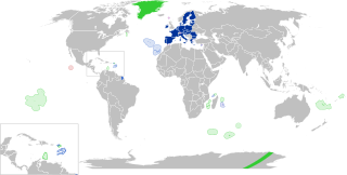
English:
European Union
Outermost regions
Overseas countries and territories
Special cases
Other special territories Français : Union européenne
Régions ultrapériphériques
Pays et territoires d'outre-mer
Cas spéciaux
Autres territoires spéciaux |
| Дата | |
| Источник | Собственная работа |
| Автор | Glentamara |
| SVG‑разработка |
Лицензирование
| Я, владелец авторских прав на это произведение, передаю его в общественное достояние. Это разрешение действует по всему миру. В некоторых странах это не может быть возможно юридически, в таком случае: Я даю право кому угодно использовать данное произведение в любых целях без каких-либо условий, за исключением таких условий, которые требуются по закону. |
История файла
Нажмите на дату/время, чтобы посмотреть файл, который был загружен в тот момент.
| Дата/время | Миниатюра | Размеры | Участник | Примечание | |
|---|---|---|---|---|---|
| текущий | 19:12, 8 июня 2022 | | 512 × 258 (835 КБ) | Nablicus | new version |
| 10:13, 17 июля 2020 |  | 512 × 259 (736 КБ) | Alcaios | fixed – those were models I use to check the scale | |
| 23:03, 16 июля 2020 |  | 512 × 258 (672 КБ) | Nablicus | Reverted to version as of 19:08, 16 July 2020 (UTC). There is an extra UK and Iceland in the middle of Canada... | |
| 19:53, 16 июля 2020 |  | 512 × 259 (753 КБ) | Alcaios | frame | |
| 19:50, 16 июля 2020 |  | 512 × 258 (681 КБ) | Alcaios | minor fixed on Greenland mar. zone | |
| 19:46, 16 июля 2020 |  | 512 × 258 (681 КБ) | Alcaios | Added maritime zone of Gree,land based on https://www.marineregions.org/eezdetails.php?mrgid=8438 | |
| 19:32, 16 июля 2020 |  | 512 × 259 (752 КБ) | Alcaios | added Faroe Islands' maritime zone | |
| 19:08, 16 июля 2020 |  | 512 × 258 (672 КБ) | Alcaios | Maritime zones in the eastern Caribbean at the right scale, with the help of https://commons.wikimedia.org/wiki/File:Caribbean_maritime_boundaries_map.svg | |
| 18:44, 16 июля 2020 |  | 512 × 259 (742 КБ) | Alcaios | slight realignments | |
| 18:38, 16 июля 2020 |  | 512 × 259 (742 КБ) | Alcaios | typo in previous edit, read: "Northern Cyprus is not a special member state territory since..." –– the Åland archipelago is larger and almost reaches the Finnish coast |
Использование файла
Следующие 2 страницы используют этот файл:
Глобальное использование файла
Данный файл используется в следующих вики:
- Использование в ar.wikipedia.org
- Использование в br.wikipedia.org
- Использование в cs.wikipedia.org
- Использование в de.wikipedia.org
- Использование в en.wikipedia.org
- European Union
- Neocolonialism
- Outline of the European Union
- Special territories of members of the European Economic Area
- Potential enlargement of the European Union
- External border of the European Union
- User:Xicomaia/sandbox
- User:Spinykitsune65/sandbox2
- User:A diehard editor/sandbox/EU infobox
- User:Falcaorib/World Alliances
- Использование в fa.wikipedia.org
- Использование в fr.wikipedia.org
- Aruba
- Ceuta
- Polynésie française
- Groenland
- Açores
- Saint-Pierre-et-Miquelon
- Îles Canaries
- Madère
- Îles Kerguelen
- Île Clipperton
- Îles Féroé
- Région ultrapériphérique
- Îles Éparses de l'océan Indien
- Curaçao
- Åland
- Melilla
- Archipel Crozet
- Terre Adélie
- Bonaire
- Saba
- Saint-Eustache (Antilles)
- Peñón de Vélez de la Gomera
- Peñón de Alhucemas
- Îles Saint-Paul et Amsterdam
- Plazas de soberanía
- Nouvelle-Calédonie
- Saint-Martin (royaume des Pays-Bas)
- Saint-Martin (Antilles françaises)
- Pays et territoire d'outre-mer
- Saint-Barthélemy (Antilles françaises)
- Union européenne
- États membres de l'Union européenne
- Terres australes et antarctiques françaises
Просмотреть глобальное использование этого файла.