Файл:BorahPeakID.jpg
Перейти к навигации
Перейти к поиску
Размер этого предпросмотра: 800 × 441 пкс. Другие разрешения: 320 × 176 пкс | 640 × 353 пкс.
Исходный файл (1089 × 600 пкс, размер файла: 125 Кб, MIME-тип: image/jpeg)
Этот файл находится на Викискладе. Сведения о нём показаны ниже.
Викисклад — централизованное хранилище для свободных файлов, используемых в проектах Викимедиа.
|
Краткое описание
| Описание |
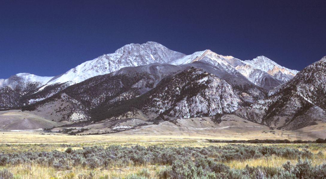
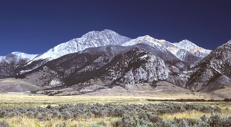
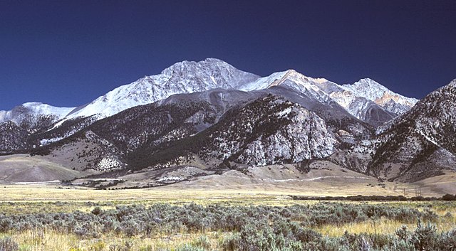
English: Borah Peak, Idaho, looking east. The normal climbing route begins in the wooded canyon at center left. The white line running along the base of the peak is the fault trace from the 1983 earthquake. |
| Дата | 6 мая 2006 (дата первоначальной загрузки файла на вики) |
| Источник | Перенесено с en.wikipedia на Викисклад участником RedWolf при помощи CommonsHelper. |
| Автор | G. Thomas из английский Википедия |
Лицензирование
| Автор этого произведения, G. Thomas из английский Википедия, передаёт его в общественное достояние. Это разрешение действует по всему миру. В некоторых странах это не может быть возможно юридически, в таком случае: G. Thomas предоставляет любому право использовать данное произведение в любых целях, без каких-либо условий, если только такие условия не требуются по закону. |
Исходный журнал загрузок
Первоначальная страница описания находилась здесь. Все нижеперечисленные имена участников относятся к en.wikipedia.
- 2006-05-06 20:17 G. Thomas 1089×600× (127941 bytes) Borah Peak, Idaho, looking east. The normal climbing route begins in the wooded canyon at center left. The white line running along the base of the peak is the fault trace from the 1983 earthquake.
История файла
Нажмите на дату/время, чтобы посмотреть файл, который был загружен в тот момент.
| Дата/время | Миниатюра | Размеры | Участник | Примечание | |
|---|---|---|---|---|---|
| текущий | 16:15, 21 февраля 2009 | | 1089 × 600 (125 Кб) | RedWolf | {{Information |Description={{en|Borah Peak, Idaho, looking east. The normal climbing route begins in the wooded canyon at center left. The white line running along the base of the peak is the fault trace from the 1983 earthquake.}} |Source=Transferred f |
Использование файла
Следующие 2 страницы используют этот файл:
Глобальное использование файла
Данный файл используется в следующих вики:
- Использование в bg.wikipedia.org
- Использование в cs.wikipedia.org
- Использование в en.wikipedia.org
- List of mountains of the United States
- Borah Peak
- List of U.S. states and territories by elevation
- Lost River Range
- List of the most isolated major summits of the United States
- List of ultras of North America
- List of the most prominent summits of the United States
- List of the major 100-kilometer summits of North America
- Mountain states
- List of the highest major summits of North America
- List of the major 3000-meter summits of the Rocky Mountains
- List of the highest major summits of the United States
- Использование в es.wikipedia.org
- Использование в it.wikipedia.org
- Использование в it.wikivoyage.org
- Использование в nl.wikipedia.org
- Использование в pt.wikipedia.org
- Использование в simple.wikipedia.org
- Использование в uk.wikipedia.org