Файл:EasternVirginia1775.jpg

Исходный файл (3360 × 2660 пкс, размер файла: 2,84 Мб, MIME-тип: image/jpeg)
Этот файл находится на Викискладе. Сведения о нём показаны ниже.
Викисклад — централизованное хранилище для свободных файлов, используемых в проектах Викимедиа.
|
Краткое описание
| Описание |
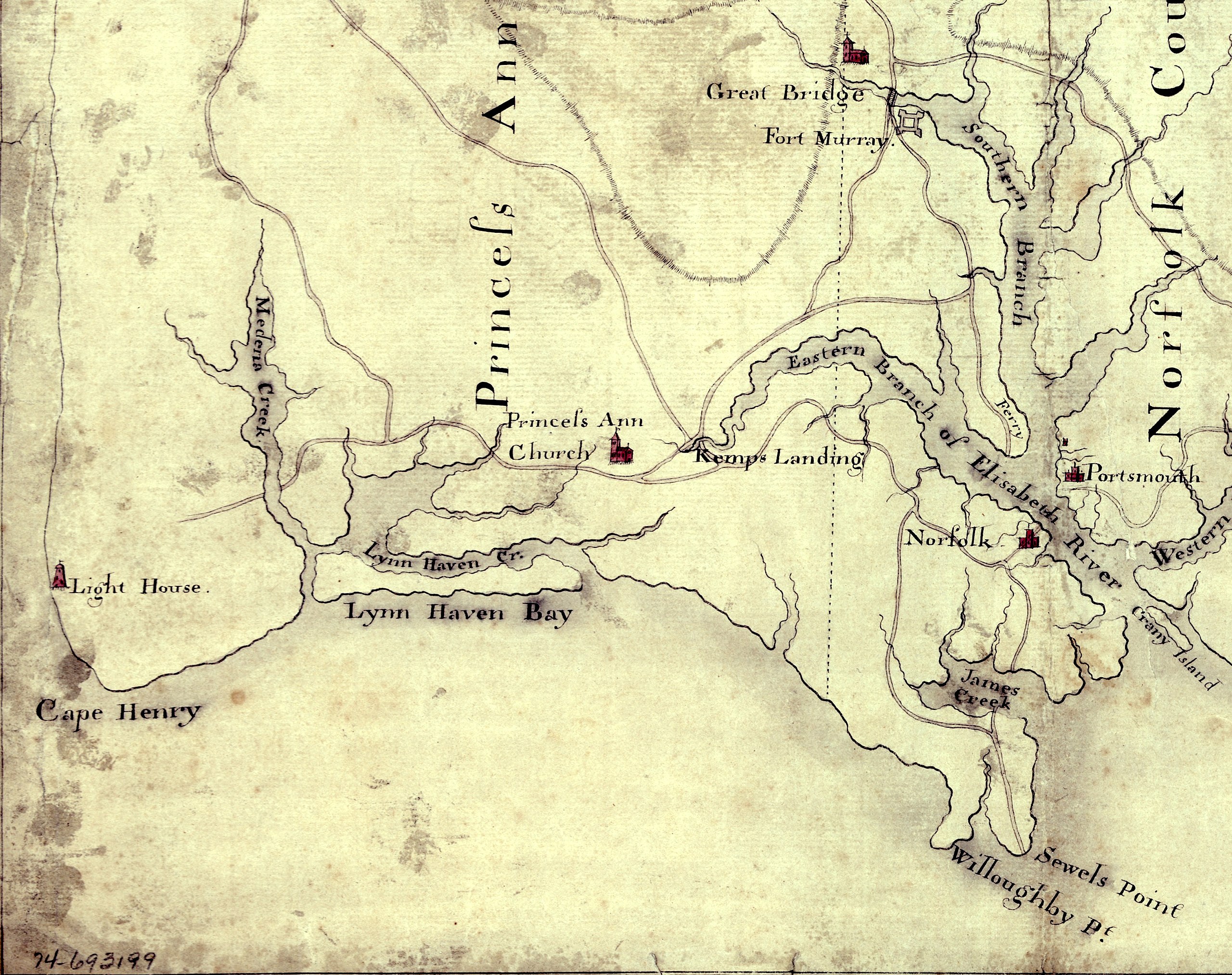
English: Detail of a 1780s manuscript map depicting the eastern coastal areas of Virginia, including portions of "Princess Anne" and Norfolk counties. The map is oriented with North to the bottom and South to the top. Part of the mouth of Chesapeake Bay is visible at the bottom of the map. The map depicts the sites of several military actions fought on land in the early days of the American Revolutionary War, including w:en:Battle of Kemp's Landing, w:en:Battle of Great Bridge, and the w:en:Burning of Norfolk, and the site of two sea battles of the war, the First and Second Battles of the Capes, the latter also known as w:en:Battle of the Chesapeake. |
||
| Дата | около 1785 (Following a logistical and political delay of about 17 years, construction of the Cape Henry Lighthouse w:en:Cape Henry Light, depicted on the map, began about 1791 and was completed in 1792), LC claims "1779?;" Worldcat [1] claims "1785?". [See also "Early Map of First Colony’s Easternmost Landscape, Landmarks and Landowners"[2].]Hogident (обсуждение) 08:12, 26 January 2015 (UTC) | ||
| Источник |
|
||
| Автор | Неизвестен | ||
| Права (Повторное использование этого файла) |
[NP: Request a change in file name, since it contains a contradiction in the date(s) of the map.] |

Лицензирование
|
Это произведение находится в общественном достоянии в тех странах, где срок охраны авторского права равен жизни автора плюс 70 лет и менее.
| |
| Этот файл был определён как свободный от известных ограничений авторского права, а также связанных и смежных прав. | |
История файла
Нажмите на дату/время, чтобы посмотреть файл, который был загружен в тот момент.
| Дата/время | Миниатюра | Размеры | Участник | Примечание | |
|---|---|---|---|---|---|
| текущий | 15:58, 5 августа 2010 | | 3360 × 2660 (2,84 Мб) | Magicpiano | {{Information |Description={{en|Detail of a 1770s manuscript map depicting the eastern coastal areas of Virginia, including portions of Princess Ann and Norfolk Counties. The map is oriented with North to the bottom and South to the top. Part of the |
Использование файла
Следующая страница использует этот файл:
Глобальное использование файла
Данный файл используется в следующих вики:
- Использование в ca.wikipedia.org
- Использование в en.wikipedia.org
- Использование в fi.wikipedia.org
- Использование в fr.wikipedia.org
- Использование в ja.wikipedia.org
- Использование в pt.wikipedia.org
- Использование в www.wikidata.org