Файл:SIR-B Sudbury Impact Crater.jpg
SIR-B_Sudbury_Impact_Crater.jpg (432 × 249 пкс, размер файла: 87 Кб, MIME-тип: image/jpeg)
Этот файл находится на Викискладе. Сведения о нём показаны ниже.
Викисклад — централизованное хранилище для свободных файлов, используемых в проектах Викимедиа.
|
Краткое описание
| Описание |
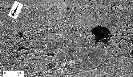
English: A SIR-B radar image of southern Ontario highlights two juxtaposed but unrelated craters that are very different in age, in size, and in structural state.
SIR-B radar image of the Sudbury impact structure (elliptical because of deformation by Grenville thrusting) and the nearby Wanapitei crater (lake-filled) formed much later. The partially circular lake-filled structure on the right (east) is the 8 km (5 mi) wide Wanapitei crater, estimated to have formed 34 million years (m.y.) ago. The far larger Sudbury structure (second largest on Earth) appears as a pronounced elliptical pattern, more strongly expressed by the low hills to the north. This huge impact crater, with its distinctive outline, was created about 1800 m.y. ago. Some scientists argue that it was at least 245 km (152 mi) across when it was circular. More than 900 m.y. later strong northwestward thrusting of the Grenville Province terrane against the Superior Province (containing Sudbury) subsequently deformed it into its present elliptical shape (geologists will recognize this as a prime example of the "strain ellipsoid" model). After Sudbury was initially excavated, magmas from deep in the crust invaded the breccia filling, mixing with it and forming a boundary layer against its walls. Some investigators think that the resulting norite rocks are actually melted target rocks. This igneous rock (called an "irruptive") is host to vast deposits of nickel and copper, making this impact structure a 5 billion dollar source of ore minerals since mining began in the last century. Further information found here: http://www.data.gov/geodata/g599452, Full credits here: http://www.geodata.gov/E-FW/DiscoveryServlet?uuid={31FB4C05-E523-8C6C-CD83-41E4435A90FE}&xmltransform=metadata_details.xsl, Shuttle mission data here: http://southport.jpl.nasa.gov/scienceapps/sirb.htmlFrançais : Image prise sur la navette spatiale Challenger en 1984 du Bassin de Sudbury. Le lac Wanapitei en haut à droite est un cratère d'impact plus jeune que le Bassin. Riche en minerais, plusieurs mines se trouvent dans le bassin, notamment des mines de nickel et de cuivre. |
| Дата | SIR-B was launched on October 5, 1984 aboard the Space Shuttle Challenger on flight 41-G |
| Источник | http://rst.gsfc.nasa.gov/Sect18/Sect18_5.html |
| Автор | Astronauts on Space Shuttle Challenger on flight 41-G |
| Другие версии | Taken from: http://rst.gsfc.nasa.gov/Sect18/Sect18_5.html |
Лицензирование
| Этот файл находится в общественном достоянии (англ. public domain), так как он был создан NASA (Национальным управлением по аэронавтике и исследованию космического пространства). Политика авторского права NASA гласит, что «Материал NASA не защищается авторским правом, если не указано иное». (См. Template:PD-USGov, страницу политики авторского права NASA или политику использования изображений JPL.) | ||
 |
Предупреждения:
|
История файла
Нажмите на дату/время, чтобы посмотреть файл, который был загружен в тот момент.
| Дата/время | Миниатюра | Размеры | Участник | Примечание | |
|---|---|---|---|---|---|
| текущий | 19:46, 2 января 2017 | | 432 × 249 (87 Кб) | Quibik | desaturate since it is a single-band image |
| 04:09, 14 июня 2011 |  | 432 × 249 (92 Кб) | Oaktree b | {{Information |Description ={{en|1=A SIR-B radar image of southern Ontario highlights two juxtaposed but unrelated craters that are very different in age, in size, and in structural state. SIR-B radar image of the Sudbury impact structure (elliptical |
Использование файла
Следующие 2 страницы используют этот файл:
Глобальное использование файла
Данный файл используется в следующих вики:
- Использование в bg.wikipedia.org
- Использование в en.wikipedia.org
- Использование в en.wikiversity.org
- Использование в fi.wikipedia.org
- Использование в fr.wikipedia.org
- Использование в he.wikipedia.org
- Использование в it.wikipedia.org
- Использование в ja.wikipedia.org
- Использование в pl.wikipedia.org
- Использование в simple.wikipedia.org
- Использование в zh.wikipedia.org