Файл:Samaria, Jordan-Israel border.gif

Исходный файл (1704 × 1506 пкс, размер файла: 109 Кб, MIME-тип: image/gif)
Этот файл находится на Викискладе. Сведения о нём показаны ниже.
Викисклад — централизованное хранилище для свободных файлов, используемых в проектах Викимедиа.
|
Краткое описание
| Описание |
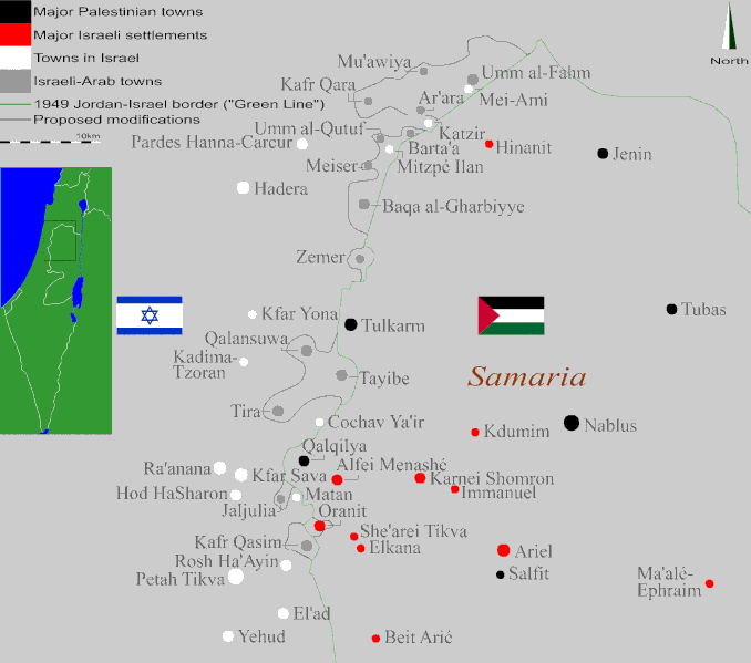
English: To-the-topic examination of the experimental proposals and ideas all relating to the design of the Israel-Palestine border in the constellation of a two-state solution while one suggests that the Rhodes cease-fire line of 1949 separating Israel and the Palestinians be adapted with the objective to reflect a modern pragmatic political thinking that pursues an international division after an extended ethnic key; - in that respect all Israeli anyway-illegal settlements east of that existing line will be either dismantled or accept Palestinian rule in the future Palestinian State and the Arab villages and towns that fell within the Israeli side and are located directly adjacent to the border will, in turn, be included in the Palestinian entity and thus severed from the majorly-Jewish Israel.
This vision has met strong oppositin amidst both the Israeli Arabs themselves and large groups of Israeli right-wing supporters since first discussed, as well as deep latent objection among those in Palestine who reject, as ever since the dawn of the Mideast Conflict and as their fundamentalistic Jewish counterparts, the concept of a territorial partition whatsoever while favoring to maintain the fizz and the reciprocal attrition until gaining the entire historic land, by demography or arm equally. On the contrary, this outlook is advocated, although not widely, by pragmatic zionists who rebuff the bigotic martyrism of both sides and consider a two nation-state resolution as the only one sustainable way to ensure a peaceful future. Alongside, it is adopted by Israelis who openly assume the prospect of the gradual erosion of the Israeli sovereign hegemony as a Western democracy by natural growth of the Arab population and there sometimes observe the Arab citizens as a threat from within and are willing to reduce Israel's already-small area in favor of securing the Hebrew character of the country, which attracts accusations of racial exclusionism from both Jews and Arabs. This sketch then reviews the practical aspect of a possible annexation of areas in Israel to the Palestinian state to allow an ethnic consecutiveness, as a two-dimensional mapping study that flattens, truly, a few variables yet enables to get some visual grip of how our shared border may look – focusing on the northern West Bank frontier's villages and towns, being the densest of regions with Muslim Arab inhabitants interspersed through Israeli localities on both sides of the original cease-fire line. According to this plan all Israeli settlements built following the 1967 War on the occupied ground are to be evacuated and their dwellers settled back in Israel-proper, except Oranit which is included within Israel's boundaries despite its beyond-Green-Line position. Across that line, the Israeli-Arabs are re-bestowed of Palestinian citizenship - and their towns separated from the Israeli civil, national and political infrastructures by a new national border. They therefore become re-connected with their people in the Palestinian back-country who, in turn, gain a larger area to practice their national existance, with no single Arab person needing to displace. This border strives to indeed get as many Arab communities included in the Arab state through land contiguity while of course keeping the Israeli non-Arab villages with unchanged status, but two small Jewish communities of Israel-proper need to relocate due to their being almost enclaved by Arab population which neutralizes the practicability of trying to get the border to encircle them. These two villages, that join the 300,000 habitants of the Israeli settlements in the Palestinian territories having to migrate westwards, are Mitzpe Ilan and Mei Ami. The map is thus an honest attempt to draw a border for Israel that is as reasonable and feasible as possible & derives from a spatial approach that aims to permit a maximal intuitive attitude from people living on both sides of the border. עברית: גבול וגבול אפשרי. |
| Дата | |
| Источник | Собственная работа |
| Автор | Orrling |
Please attribute to me with appropriate crediting whenever using the image outside Wikipedia. Thanks, Orrling
Лицензирование
- Вы можете свободно:
- делиться произведением – копировать, распространять и передавать данное произведение
- создавать производные – переделывать данное произведение
- При соблюдении следующих условий:
- атрибуция – Вы должны указать авторство, предоставить ссылку на лицензию и указать, внёс ли автор какие-либо изменения. Это можно сделать любым разумным способом, но не создавая впечатление, что лицензиат поддерживает вас или использование вами данного произведения.
- распространение на тех же условиях – Если вы изменяете, преобразуете или создаёте иное произведение на основе данного, то обязаны использовать лицензию исходного произведения или лицензию, совместимую с исходной.
История файла
Нажмите на дату/время, чтобы посмотреть файл, который был загружен в тот момент.
| Дата/время | Миниатюра | Размеры | Участник | Примечание | |
|---|---|---|---|---|---|
| текущий | 06:17, 8 сентября 2012 | | 1704 × 1506 (109 Кб) | Orrling | Added North-signal |
| 23:08, 7 сентября 2012 |  | 1704 × 1506 (107 Кб) | Orrling | Turned out some components were not too visible, fixed it | |
| 22:53, 7 сентября 2012 |  | 1704 × 1506 (107 Кб) | Orrling | Some graphic adaptations | |
| 09:07, 7 сентября 2012 |  | 1704 × 1506 (103 Кб) | Orrling | User created page with UploadWizard |
Использование файла
Следующая страница использует этот файл:
Глобальное использование файла
Данный файл используется в следующих вики:
- Использование в ga.wikipedia.org
- Использование в sv.wikipedia.org