Файл:South Island.jpg

Исходный файл (2618 × 2926 пкс, размер файла: 1,26 Мб, MIME-тип: image/jpeg)
Этот файл находится на Викискладе. Сведения о нём показаны ниже.
Викисклад — централизованное хранилище для свободных файлов, используемых в проектах Викимедиа.
|
Краткое описание
| Описание |
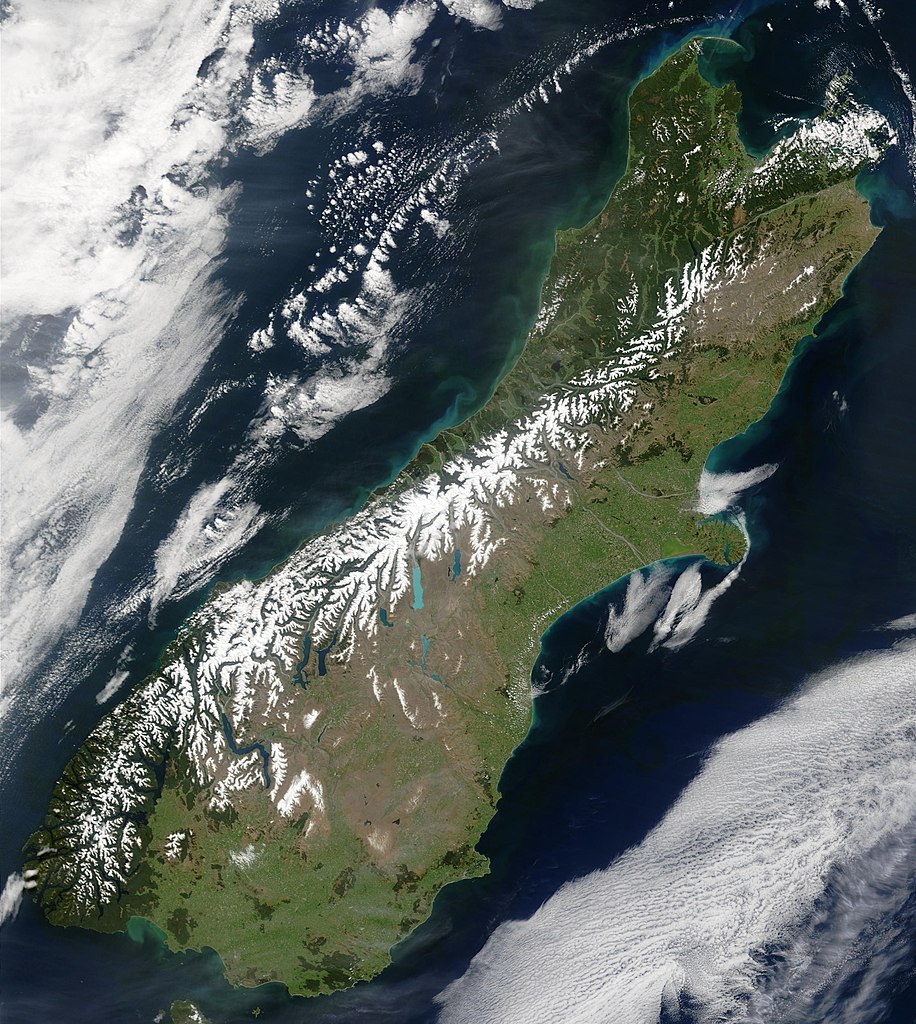
English: This true-color image provides a nearly cloud-free look at the South Island of New Zealand, from NASA’s Terra satellite.
Українська: Сніг виділяє гірські хребти Південних Альп (супутниковий знімок НАСА), Нова Зеландія. |
| Дата | |
| Источник | NASA's Earth Observatory |
| Автор | Jacques Descloitres, MODIS Land Rapid Response Team at NASA GSFC |
| Права (Повторное использование этого файла) |
Public domain - original work of NASA |
| Другие версии | Image:South.island.arp.750pix.jpg is lower resolution, more tightly cropped |
This true-color image provides a nearly cloud-free look at the South Island of New Zealand. The scene was acquired by NASA’s Terra satellite, on October 23, 2002.
Forested areas are clearly indicated by the very dark green, particularly in the northwest and southwest. The braided Waimakariri and Rakaia rivers can also clearly be seen as they make their way to the east coast on either side of Banks Peninsula.
Image courtesy Jacques Descloitres, MODIS Land Rapid Response Team at NASA GSFC.
SOURCE: http://earthobservatory.nasa.gov/Newsroom/NewImages/images.php3?img_id=10881
”The purpose of NASA's Earth Observatory is to provide a freely-accessible publication on the Internet where the public can obtain new satellite imagery and scientific information about our home planet. The focus is on Earth's climate and environmental change. In particular, we hope our site is useful to public media and educators. Any and all materials published on the Earth Observatory are freely available for re-publication or re-use, except where copyright is indicated. We ask that NASA's Earth Observatory be given credit for its original materials.”
Лицензирование
| Этот файл находится в общественном достоянии (англ. public domain), так как он был создан NASA (Национальным управлением по аэронавтике и исследованию космического пространства). Политика авторского права NASA гласит, что «Материал NASA не защищается авторским правом, если не указано иное». (См. Template:PD-USGov, страницу политики авторского права NASA или политику использования изображений JPL.) | ||
 |
Предупреждения:
|
История файла
Нажмите на дату/время, чтобы посмотреть файл, который был загружен в тот момент.
| Дата/время | Миниатюра | Размеры | Участник | Примечание | |
|---|---|---|---|---|---|
| текущий | 00:48, 18 мая 2006 | | 2618 × 2926 (1,26 Мб) | Avenue | {{Information| |Description=This true-color image provides a nearly cloud-free look at the South Island of New Zealand, from NASA’s Terra satellite. |Source=[http://earthobservatory.nasa.gov/Newsroom/NewImages/images.php3?img_id=10881 NASA's Earth Obser |
Использование файла
Нет страниц, использующих этот файл.
Глобальное использование файла
Данный файл используется в следующих вики:
- Использование в af.wikipedia.org
- Использование в ang.wikipedia.org
- Использование в an.wikipedia.org
- Использование в ar.wikipedia.org
- Использование в bh.wikipedia.org
- Использование в ceb.wikipedia.org
- Использование в cs.wikipedia.org
- Использование в da.wikipedia.org
- Использование в de.wikipedia.org
- Использование в de.wikivoyage.org
- Использование в el.wikipedia.org
- Использование в en.wikipedia.org
- Использование в en.wikiversity.org
- Использование в eo.wikipedia.org
- Использование в et.wikipedia.org
- Использование в fa.wikipedia.org
- Использование в fi.wikipedia.org
- Использование в fr.wikipedia.org
- Использование в gl.wikipedia.org
- Использование в he.wikipedia.org
- Использование в hi.wikipedia.org
- Использование в hr.wikipedia.org
- Использование в hu.wikipedia.org
- Использование в is.wikipedia.org
- Использование в it.wikipedia.org
- Использование в ja.wikipedia.org
- Использование в mi.wikipedia.org
- Использование в mk.wikipedia.org
- Использование в ml.wikipedia.org
- Использование в mn.wikipedia.org
- Использование в nl.wikipedia.org
- Использование в nn.wikipedia.org
- Использование в no.wikipedia.org
- Использование в oc.wikipedia.org
- Использование в pnb.wikipedia.org
- Использование в pt.wikipedia.org
- Использование в sh.wikipedia.org
- Использование в sk.wikipedia.org
- Использование в sl.wikipedia.org
- Использование в sr.wikipedia.org
- Использование в sv.wikipedia.org
- Использование в tpi.wikipedia.org
- Использование в tr.wikipedia.org
Просмотреть глобальное использование этого файла.