Файл:Sweden CIA map extended.gif
Исходный файл (300 × 714 пкс, размер файла: 21 Кб, MIME-тип: image/gif)
Этот файл находится на Викискладе. Сведения о нём показаны ниже.
Викисклад — централизованное хранилище для свободных файлов, используемых в проектах Викимедиа.
|
Краткое описание
| Описание |
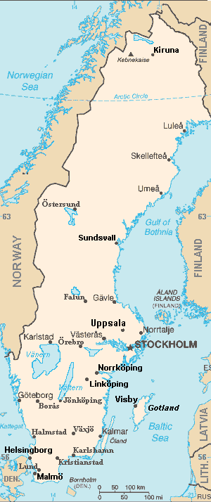
Map of Sweden, extended from CIA World Fact Book, showing largest cities, islands and lake names. Larger city names (10) have been labeled with font-face Arial or Arial Narrow, as font-size 9 or 10; the island/region names are labeled in italic font. Sweden contains over 200 towns, but they are evenly dispersed around the main southern towns, except near Copenhagen, which has very high density. This map has locator code "SwedenCIAx" for use in map-locator templates, such as English Wiki Template:Location_map_SwedenCIAx & Template:Location_map_skew (which skews northern coordinates for multiple map markers/labels). The latitude/longitude coordinates are not equirectangular, but rather, narrow at the north, with longitudes about 38% closer together at the top. The narrowing longitudes provide more accurate mapping of area and distance than with rectangular coordinates. The original map image was public domain; the following modifications have been made to the original:
|
| Дата | |
| Источник | Derivative of map from User:Fred_J changing CIA map (Wikimedia Commons): Image:Sweden from cia.png (adding 10 labels, restoring color to CIA hues & magnified 15%) |
| Автор | Wikid77 (derivative of User:Fred_J form of CIA map, adding 10 labels) |
| Другие версии |
This map has some variations:
|
Лицензирование
- Вы можете свободно:
- делиться произведением – копировать, распространять и передавать данное произведение
- создавать производные – переделывать данное произведение
- При соблюдении следующих условий:
- атрибуция – Вы должны указать авторство, предоставить ссылку на лицензию и указать, внёс ли автор какие-либо изменения. Это можно сделать любым разумным способом, но не создавая впечатление, что лицензиат поддерживает вас или использование вами данного произведения.
- распространение на тех же условиях – если вы изменяете, преобразуете или создаёте иное производное произведение на основании этого произведения, вы должны распространять полученное в результате произведение только на условиях такой же лицензии.
Это произведение является работой сотрудников Центрального разведывательного управления, выполненной ими при составлении Справочника ЦРУ по странам мира, то есть в ходе исполнения должностных обязанностей. Будучи работой высших федеральных органов государственной власти США, произведение находится в общественном достоянии.
|
 |
Format

This file is purposely maintained in GIF format (most international GIF-related patents have expired) for compatibility with the original CIA maps. Semi-automatic conversions to PNG-format might lose the color hues of the CIA maps, tending to shift to lighter blue and shift beige to white. A larger, detailed version of the map is being expanded, with more of the smaller 200 towns added.
История файла
Нажмите на дату/время, чтобы посмотреть файл, который был загружен в тот момент.
| Дата/время | Миниатюра | Размеры | Участник | Примечание | |
|---|---|---|---|---|---|
| текущий | 18:44, 5 сентября 2007 | | 300 × 714 (21 Кб) | Wikid77 | completed east border of Sweden; enlarged "Helsingborg" & "Malmo" etc. |
| 12:33, 5 сентября 2007 |  | 300 × 714 (21 Кб) | Wikid77 | ==Summary== {{Information | Description= Map of Sweden, from CIA World Fact Book, with extensions for more town names and lakes. The original map image was public domain; the following modifications have been made to the original: * Drawing in lakes [[w:V |
Использование файла
Следующая страница использует этот файл:
Глобальное использование файла
Данный файл используется в следующих вики:
- Использование в ar.wikipedia.org
- Использование в bn.wikipedia.org
- Использование в en.wikipedia.org
- User:Wikid77/Template:Location map skew
- User:Wikid77/Template:Location map skew/doc
- User:Wikid77/Template:Location map polarx
- User:Wikid77/Template:Location map polarx/doc
- User:Wikid77/Template:Location map SwedenCIAx
- Module talk:Location map/data/Sweden
- User:Wikid77/Template:Location map SwedenCIAskew
- Использование в kk.wikipedia.org
- Использование в kn.wikipedia.org
- Использование в ky.wikipedia.org
- Использование в mrj.wikipedia.org
- Использование в no.wikipedia.org
- Использование в uk.wikipedia.org
- Использование в yo.wikipedia.org