Файл:Austria satellite-map.jpg

Исходный файл (2550 × 1381 пкс, размер файла: 1,22 Мб, MIME-тип: image/jpeg)
Этот файл находится на Викискладе. Сведения о нём показаны ниже.
Викисклад — централизованное хранилище для свободных файлов, используемых в проектах Викимедиа.
|
Краткое описание
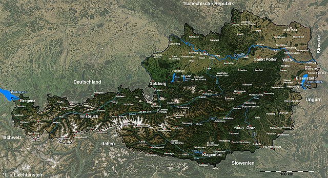
| Описание | Satellite image of Austria with provincial capitals and other annotations |
| Дата | |
| Источник |
The image is based on a satellite image from [1]. Original image: Credit Jeff Schmaltz, MODIS Rapid Response Team, NASA/GSFC. |
| Автор | Michael Schmid |
| Права (Повторное использование этого файла) |
Based on a NASA image, thus in the public domain. |
| Другие версии | Image:Austria_satellite_unannotated.jpg with no annotations except dots at the positions of a few cities, Image:Austria_satellite_annotated.jpg with some limited annotations. |
![[1]](http://visibleearth.nasa.gov/images/5947/Italy.A2003262.1005.250m.jpg)
I have marked and labelled quite a lot of places with the help of the NASA Worldwind software and several maps. It was quite some work, but also a nice exercise in geography for me ;-).
Unless I have forgotten something, the map shows (among other cities) the capitals of all districts and provinces of Austria.
Please note: The cities of Wien (Vienna) and Linz were marked a few kilometers from their actual locations in the original satellite image; this has been corrected here.[2].
Das Bild wurde in y-Richtung um ca. 5% gestreckt, um eine wenig verzerrte Karte zu erhalten. Um Österreich hervorzuheben, habe ich den Kontrast außerhalb der Grenzen Österreichs reduziert und die Grenzlinie dicker eingezeichnet, und danach durch Vergleich mit der NASA Worldwind Software und diversen Karten die Positionen diverser Orte, Berge und Pässe bestimmt und eingezeichnet.
Die Karte enthält (wenn ich keine vergessen habe) unter anderem alle Landes- und Bezirkshauptstädte Österreichs.Лицензирование
| Этот файл находится в общественном достоянии (англ. public domain), так как он был создан NASA (Национальным управлением по аэронавтике и исследованию космического пространства). Политика авторского права NASA гласит, что «Материал NASA не защищается авторским правом, если не указано иное». (См. Template:PD-USGov, страницу политики авторского права NASA или политику использования изображений JPL.) | ||
 |
Предупреждения:
|
История файла
Нажмите на дату/время, чтобы посмотреть файл, который был загружен в тот момент.
| Дата/время | Миниатюра | Размеры | Участник | Примечание | |
|---|---|---|---|---|---|
| текущий | 19:41, 11 сентября 2005 | | 2550 × 1381 (1,22 Мб) | Schmid | {{Information| |Description = Satellite image of Austria with provincial capitals and other annotations | Source = The image is based on a satellite image from [http://visibleearth.nasa.gov/images/5947/Italy.A2003262.1005.250m.jpg]. Original image: Cre |
Использование файла
Следующие 2 страницы используют этот файл:
Глобальное использование файла
Данный файл используется в следующих вики:
- Использование в af.wikipedia.org
- Использование в cs.wikipedia.org
- Использование в da.wikipedia.org
- Использование в de.wikipedia.org
- Использование в en.wikipedia.org
- Использование в fr.wikipedia.org
- Использование в hu.wikipedia.org
- Использование в hy.wikipedia.org
- Использование в hyw.wikipedia.org
- Использование в ku.wikipedia.org
- Использование в nn.wikipedia.org
- Использование в no.wikipedia.org
- Использование в rm.wikipedia.org
- Использование в sk.wikipedia.org
- Использование в tl.wikipedia.org
- Использование в tr.wikipedia.org
- Использование в uk.wikipedia.org