Перейти на страницу файла на Викискладе

Файл:Cotahuasi Canyon oblique.jpg

Материал из Википедии — свободной энциклопедии
Перейти к навигации Перейти к поиску

Cotahuasi_Canyon_oblique.jpg(720 × 480 пкс, размер файла: 515 КБ, MIME-тип: image/jpeg)

Краткое описание

Описание
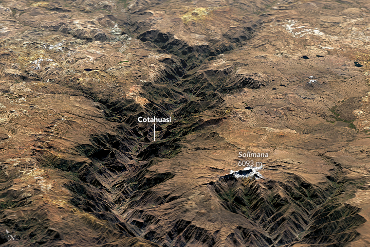
English: Cotahuasi Canyon in Peru stands as a potent reminder of the tremendous erosive power of water and ice. Cutting through a towering plateau—a product of repeated volcanic eruptions and tectonic uplift—the canyon is one of the deepest in the world.

Cotahuasi formed over the course of several million years as rivers and glaciers chiseled into the plateau. The relief from the canyon floor to the rim ranges from 2.5 to 3.5 kilometers (1.5 to 2.2 miles), making Cotahuasi Canyon about twice as deep as the Grand Canyon.

On June 3, 2016, the Operational Land Imager (OLI) on Landsat 8 passed over the canyon. The top image shows Landsat data draped over topographic data from NASA’s Shuttle Radar Topography Mission (SRTM). The second image is a nadir (straight down) view from OLI of the area near the town of Cotahuasi.

Evidence of volcanic activity surrounds the canyon. To the south, snow-capped Solimana, an inactive stratovolcano that last erupted about 500,000 years ago, soars above the plateau. Colorful yellow and orange volcanic deposits are visible around the north rim of the canyon.

More info & refs at source URL
Дата
Источник https://earthobservatory.nasa.gov/IOTD/view.php?id=91686&src=eoa-iotd
Автор NASA Earth Observatory images by Joshua Stevens, using Landsat data from the U.S. Geological Survey.
Права
(Повторное использование этого файла)
Public domain Этот файл находится в общественном достоянии (англ. public domain), так как он был создан NASA (Национальным управлением по аэронавтике и исследованию космического пространства). Политика авторского права NASA гласит, что «Материал NASA не защищается авторским правом, если не указано иное». (См. Template:PD-USGov, страницу политики авторского права NASA или политику использования изображений JPL.)
Предупреждения:

Краткие подписи

Добавьте однострочное описание того, что собой представляет этот файл

Элементы, изображённые на этом файле

изображённый объект

image/jpeg

527 255 байт

480 пиксель

720 пиксель

История файла

Нажмите на дату/время, чтобы посмотреть файл, который был загружен в тот момент.

Дата/времяМиниатюраРазмерыУчастникПримечание
текущий22:59, 13 февраля 2018Миниатюра для версии от 22:59, 13 февраля 2018720 × 480 (515 КБ)Tillman{{Information |Description ={{en|1=Cotahuasi Canyon in Peru stands as a potent reminder of the tremendous erosive power of water and ice. Cutting through a towering plateau—a product of repeated volcanic eruptions and tectonic uplift—the canyon...

Следующая страница использует этот файл:

Глобальное использование файла

Данный файл используется в следующих вики:

Метаданные