Файл:Mars Viking 22a002.png
Перейти к навигации
Перейти к поиску

Размер этого предпросмотра: 800 × 156 пкс. Другие разрешения: 320 × 62 пкс | 640 × 125 пкс | 2626 × 512 пкс.
Исходный файл (2626 × 512 пкс, размер файла: 361 КБ, MIME-тип: image/png)
Этот файл находится на Викискладе. Сведения о нём показаны ниже.
Викисклад — централизованное хранилище для свободных файлов, используемых в проектах Викимедиа.
|
Краткое описание
| Описание |
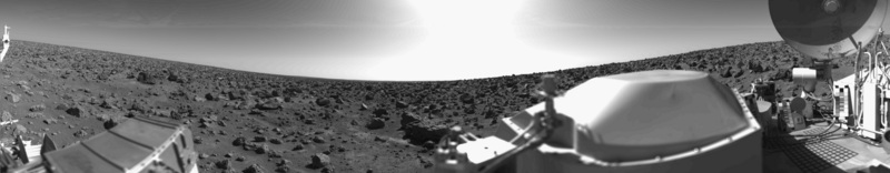
English: Original Caption Released with NASA Image: This rocky panoramic scene is the second picture of the Martian surface that was taken by Viking Lander 2 shortly after touchdown on September 3 at 3:58 PM PDT (Earth received time). The site is on a northern plain of Mars, at about 48 N. Lat., 226 W. Long., known as Utopia Planitia. The picture sweeps around 330 degrees in azimuth, starting from northwest at the left through north (above the sampler arm housing) past east, where the sky is bright at the center, and southeast toward the right above the radioisotope thermoelectric generator cover. The surface is strewn with rocks out to the horizon, ranging in size up to several meters across. Some pitted rocks resemble fragments of porous volcanic lava. Other rocks have grooves that may have been eroded by windblown sand and dust. Although fine-grained material is seen between the boulders, no sand dunes are evident. The dip in the eastern horizon at the center is an illusion caused by an 8-degree tilt of the Lander toward the west. Actually, the terrain is more level than that at the Viking 1 site. The horizon toward the left of the panorama (northwest) appears featureless, indicating that it may be several kilometers distant. The sky at the center (east) is bright because the sun was above but out of the picture at 10 AM Mars time. Toward the right (southeast), the rocks that are silhouetted against the skyline indicate that the horizon is much nearer, probably because of a slight rise in that area of the terrain. The circular high-gain antenna at the right has clots of fine-grained material adhering to the lower half, some of which appeared to have been sliding downward while the camera was scanning the area. At the extreme right, the banded appearance resulted because the camera continued to scan while it was no longer moving in azimuth. Any motion or other variation in the scene would show up as a change in successive lines. |
| Дата | 2010-02-17; original photo was taken 1977-09-03. |
| Источник | Own work based on images in the NASA Viking image archive |
| Автор | "Roel van der Hoorn (Van der Hoorn)" |
| Права (Повторное использование этого файла) |
I used the original 22a002.sur image from the NASA Viking image archive, converted it to .png and manually removed the noise. Except for the conversion, this was done in Adobe Photoshop CS2 and Adobe Photoshop CS4. The original file by NASA is in the public domain, and so is this new one. |
| Другие версии | I created this image as a replacement for the File:Vl2.jpg. This file was created by NASA, but the quality is not very high, especially on the right side. Using the original pictures from the Lander archive resulted in a higher quality image. |
Лицензирование
| Автор этого произведения, Van der Hoorn из английский Википедия, передаёт его в общественное достояние. Это разрешение действует по всему миру. В некоторых странах это не может быть возможно юридически, в таком случае: Van der Hoorn предоставляет любому право использовать данное произведение в любых целях, без каких-либо условий, если только такие условия не требуются по закону. |
The image is based on an original image from NASA to which the following copyright statement is applicable:
| Этот файл находится в общественном достоянии (англ. public domain), так как он был создан NASA (Национальным управлением по аэронавтике и исследованию космического пространства). Политика авторского права NASA гласит, что «Материал NASA не защищается авторским правом, если не указано иное». (См. Template:PD-USGov, страницу политики авторского права NASA или политику использования изображений JPL.) | ||
 |
Предупреждения:
|
История файла
Нажмите на дату/время, чтобы посмотреть файл, который был загружен в тот момент.
| Дата/время | Миниатюра | Размеры | Участник | Примечание | |
|---|---|---|---|---|---|
| текущий | 00:31, 17 февраля 2010 | 2626 × 512 (361 КБ) | Van der Hoorn | {{Information |Description={{en|1='''Original Caption Released with NASA Image:'''<br />This rocky panoramic scene is the second picture of the Martian surface that was taken by Viking Lander 2 shortly after touchdown on September 3 at 3:58 PM PDT (Earth |
Использование файла
Следующая страница использует этот файл:
Глобальное использование файла
Данный файл используется в следующих вики:
- Использование в ca.wikipedia.org
- Использование в de.wikipedia.org
- Использование в en.wikipedia.org
- Использование в es.wikipedia.org
- Использование в fr.wikipedia.org
- Использование в he.wikipedia.org
- Использование в it.wikipedia.org
- Использование в ja.wikipedia.org
- Использование в kk.wikipedia.org
- Использование в lmo.wikipedia.org
- Использование в lt.wikipedia.org
- Использование в uk.wikipedia.org
- Использование в vi.wikipedia.org
- Использование в zh.wikipedia.org