Файл:PIA21136 Scalloped Terrain Led to Finding of Buried Ice on Mars.jpg
PIA21136_Scalloped_Terrain_Led_to_Finding_of_Buried_Ice_on_Mars.jpg (640 × 398 пкс, размер файла: 57 КБ, MIME-тип: image/jpeg)
Этот файл находится на Викискладе. Сведения о нём показаны ниже.
Викисклад — централизованное хранилище для свободных файлов, используемых в проектах Викимедиа.
|
Краткое описание
| Описание |
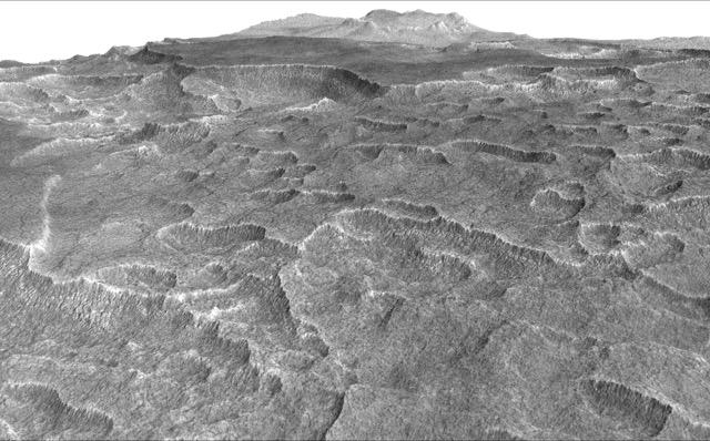
English: This vertically exaggerated view shows scalloped depressions in Mars' Utopia Planitia region, one of the area's distinctive textures that prompted researchers to check for underground ice, using ground-penetrating radar aboard NASA's Mars Reconnaissance Orbiter.
More than 600 overhead passes with the spacecraft's Shallow Radar (SHARAD) instrument provided data for determining that about as much water as the volume of Lake Superior lies in a thick layer beneath a portion of Utopia Planitia. These scalloped depressions on the surface are typically about 100 to 200 yards or meters wide. The foreground of this view covers ground about one mile (1.8 kilometers) across. The perspective view is based on a three-dimensional terrain model derived from a stereo pair of observations by the High Resolution Imaging Science Experiment (HiRISE) camera on the Mars Reconnaissance Orbiter. One was taken on Dec. 25, 2006, the other on Feb. 2, 2007. The vertical dimension is exaggerated fivefold in proportion to the horizontal dimensions, to make texture more apparent in what is a rather flat plain. Similar scalloped depressions are found in portions of the Canadian Arctic, where they are indicative of ground ice. The University of Arizona, Tucson, operates HiRISE, which was built by Ball Aerospace & Technologies Corp., Boulder, Colo. NASA's Jet Propulsion Laboratory, a division of Caltech in Pasadena, California, manages the Mars Reconnaissance Orbiter Project for NASA's Science Mission Directorate, Washington. |
| Дата | (published 22 ноября 2016) |
| Источник | Catalog page · Full-res (JPEG · TIFF) |
| Автор | NASA/JPL-Caltech/Univ. of Arizona |
Это изображение или видеозапись внесены в каталог Лаборатории реактивного движения НАСА под идентификатором (Photo ID): PIA21136. Этот шаблон не указывает на правовой статус данной работы. По-прежнему необходим нормальный шаблон лицензий. См. Commons:Лицензирование. Другие языки:
|
 |
This media is a product of the Mars Reconnaissance Orbiter mission Credit and attribution belongs to the High Resolution Imaging Science Experiment (HiRISE) team, NASA/JPL-Caltech/Univ. of Arizona |
Лицензирование
| Этот файл находится в общественном достоянии (англ. public domain), так как он был создан NASA (Национальным управлением по аэронавтике и исследованию космического пространства). Политика авторского права NASA гласит, что «Материал NASA не защищается авторским правом, если не указано иное». (См. Template:PD-USGov, страницу политики авторского права NASA или политику использования изображений JPL.) | ||
 |
Предупреждения:
|
История файла
Нажмите на дату/время, чтобы посмотреть файл, который был загружен в тот момент.
| Дата/время | Миниатюра | Размеры | Участник | Примечание | |
|---|---|---|---|---|---|
| текущий | 22:05, 23 ноября 2016 | | 640 × 398 (57 КБ) | Drbogdan | User created page with UploadWizard |
Использование файла
Следующая страница использует этот файл:
Глобальное использование файла
Данный файл используется в следующих вики:
- Использование в ar.wikipedia.org
- Использование в bn.wikipedia.org
- Использование в ca.wikipedia.org
- Использование в el.wikipedia.org
- Использование в en.wikipedia.org
- Использование в eo.wikipedia.org
- Использование в es.wikipedia.org
- Использование в kk.wikipedia.org
- Использование в zh.wikipedia.org