Файл:Tanggu Truce Map.jpg
Перейти к навигации
Перейти к поиску

Размер этого предпросмотра: 794 × 600 пкс. Другие разрешения: 318 × 240 пкс | 635 × 480 пкс | 1016 × 768 пкс | 1280 × 967 пкс | 1985 × 1500 пкс.
Исходный файл (1985 × 1500 пкс, размер файла: 403 Кб, MIME-тип: image/jpeg)
Этот файл находится на Викискладе. Сведения о нём показаны ниже.
Викисклад — централизованное хранилище для свободных файлов, используемых в проектах Викимедиа.
|
Краткое описание
| Описание |
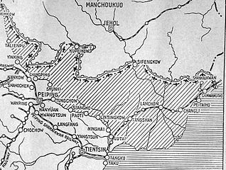
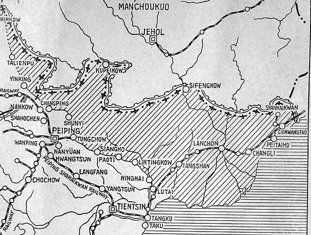
English: The shaded part of this map shows the areas demilitarized by the Tanggu Truce. Note also that the remainder of the Hebei Province, including Beijing and Tianjin, would also be demilitarized of Nationalist forces under the terms of the He-Umezu Agreement, but independent warlords like Song Zheyuan continued to operate there. |
| Дата | |
| Источник | a pamphlet called "Sino-Japanese Conflict Elucidated" |
| Автор | Canadian Japanese Association |
Лицензирование
This Canadian work, of which the author or authors are unknown, is in the public domain in Canada because:
(R.S.C., 2020, c. C-42, s. 6.1, R.S.C., 1993, c. C-42, s. 6.1) |
 | |
|
|
История файла
Нажмите на дату/время, чтобы посмотреть файл, который был загружен в тот момент.
| Дата/время | Миниатюра | Размеры | Участник | Примечание | |
|---|---|---|---|---|---|
| текущий | 22:47, 18 октября 2012 | | 1985 × 1500 (403 Кб) | CurtisNaito | User created page with UploadWizard |
Использование файла
Следующая страница использует этот файл:
Глобальное использование файла
Данный файл используется в следующих вики:
- Использование в ar.wikipedia.org
- Использование в en.wikipedia.org
- Использование в es.wikipedia.org
- Использование в fa.wikipedia.org
- Использование в fr.wikipedia.org
- Использование в it.wikipedia.org
- Использование в ko.wikipedia.org
- Использование в lv.wikipedia.org
- Использование в nl.wikipedia.org
- Использование в pt.wikipedia.org
- Использование в uk.wikipedia.org