Файл:Taupo.Volcanic.Zone.North.Island.NZ.JPG
Исходный файл (616 × 864 пкс, размер файла: 104 КБ, MIME-тип: image/jpeg)
Этот файл находится на Викискладе. Сведения о нём показаны ниже.
Викисклад — централизованное хранилище для свободных файлов, используемых в проектах Викимедиа.
|
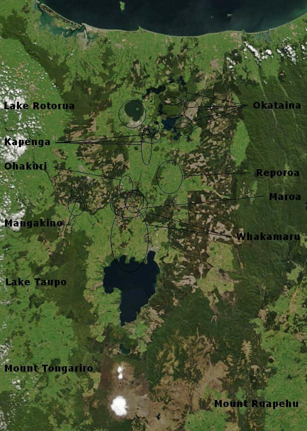
| Описание | Bay of Plenty, North Island, New Zealand, from the Bay of Plenty coast to Mounts Tongariro, Ngauruhoe, and Ruapehu (at bottom of picture). Also shows Lake Taupo and the Rotorua Lakes. This scene was acquired by the Moderate Resolution Imaging Spectroradiometer (MODIS), flying aboard NASA’s Terra satellite, on October 23, 2002 |
| Дата | (UTC) |
| Источник | |
| Автор |
|
Annotations based on: Hiess J, Cole JW, Spinks KD (2007), High-Alumina Basalts of the Taupo Volcanic Zone, New Zealand: Influence of the Crust and Crustal Structure [1]; Krippner SJP, Briggs RM, Wilson CJN, Cole JW (1998), Petrography and geochemistry of lithic fragments in ignimbrites from the Mangakino Volcanic Centre: implications for the composition of the subvolcanic crust in western Taupo Volcanic Zone, New Zealand; New Zealand Journal of Geology and Geophysics, Vol. 41: 187-199 [2] archive copy at the Wayback Machine; Newhall, Christopher G.; Dzurisin, Daniel (1988), Historical unrest at large calderas of the world, USGS Bulletin 1855, p. 1108 [3] archive copy at the Wayback Machine; Siebert L, Simkin T (2002-), Volcanoes of the World: an Illustrated Catalog of Holocene Volcanoes and their Eruptions, Smithsonian Institution, Global Volcanism Program Digital Information Series, GVP-3 [4]
| Этот файл находится в общественном достоянии (англ. public domain), так как он был создан NASA (Национальным управлением по аэронавтике и исследованию космического пространства). Политика авторского права NASA гласит, что «Материал NASA не защищается авторским правом, если не указано иное». (См. Template:PD-USGov, страницу политики авторского права NASA или политику использования изображений JPL.) | ||
 |
Предупреждения:
|
Исходный журнал загрузок
This image is a derivative work of the following images:
- File:BayofPlentyA2002296.jpg licensed with PD-USGov-NASA
- 2007-08-24T00:20:45Z Kahuroa 616x864 (505144 Bytes) == Summary == {{Information |Description=Bay of Plenty, North Island, New Zealand, from the Bay of Plenty coast to Mounts Tongariro, Ngauruhoe, and Ruapehu (at bottom of picture). Also shows Lake Taupo and the Rotorua Lakes.
Uploaded with derivativeFX
История файла
Нажмите на дату/время, чтобы посмотреть файл, который был загружен в тот момент.
| Дата/время | Миниатюра | Размеры | Участник | Примечание | |
|---|---|---|---|---|---|
| текущий | 02:17, 20 февраля 2010 | | 616 × 864 (104 КБ) | Chris.urs-o | One label was missing. |
| 01:49, 20 февраля 2010 |  | 616 × 864 (103 КБ) | Chris.urs-o | Fixed label | |
| 10:42, 19 февраля 2010 |  | 616 × 864 (105 КБ) | Chris.urs-o | Improved caldera locations | |
| 11:20, 18 февраля 2010 |  | 616 × 864 (103 КБ) | Chris.urs-o | {{Information |Description=Bay of Plenty, North Island, New Zealand, from the Bay of Plenty coast to Mounts Tongariro, Ngauruhoe, and Ruapehu (at bottom of picture). Also shows Lake Taupo and the Rotorua Lakes. This scene was acquired by the Moderate Reso |
Использование файла
Следующая страница использует этот файл:
Глобальное использование файла
Данный файл используется в следующих вики:
- Использование в ar.wikipedia.org
- Использование в de.wikipedia.org
- Использование в en.wikipedia.org
- Использование в en.wikiversity.org
- Использование в es.wikipedia.org
- Использование в fi.wikipedia.org
- Использование в id.wikipedia.org
- Использование в it.wikipedia.org
- Использование в mk.wikipedia.org
- Использование в simple.wikipedia.org
- Использование в sl.wikipedia.org
- Использование в uk.wikipedia.org