Файл:US nuclear strike map.svg
Перейти к навигации
Перейти к поиску

Размер этого PNG-превью для исходного SVG-файла: 800 × 497 пкс. Другие разрешения: 320 × 199 пкс | 640 × 397 пкс | 1024 × 636 пкс | 1280 × 795 пкс | 2560 × 1590 пкс | 950 × 590 пкс.
Исходный файл (SVG-файл, номинально 950 × 590 пкс, размер файла: 81 КБ)
Этот файл находится на Викискладе. Сведения о нём показаны ниже.
Викисклад — централизованное хранилище для свободных файлов, используемых в проектах Викимедиа.
|
Краткое описание
| Описание |
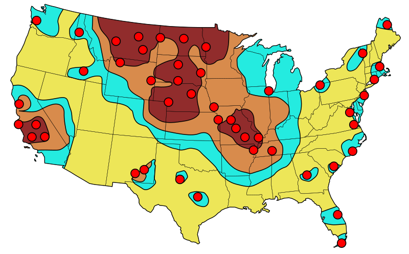
English: Primary target locations for Soviet nuclear strikes during 1980s. The resulting fall-out is indicated with the darkest considered as "lethal" to relatively fall-out free yellow zones. |
| Дата | (UTC), based on an image published in 1984 |
| Источник | |
| Автор |
|
Original source information
Federal Emergency Management Agency (FEMA), "Disaster Relief Preparatory Manual for the Washington-DC Metro Area", page 79, re-published 1984 (original publication 1974)
Original source information: FEMA, 500 C St SW, Washington DC 20472 and the phone is (202) 646-2500
Лицензирование
Я, владелец авторских прав на это произведение, добровольно публикую его на условиях следующей лицензии:
| Этот файл доступен на условиях Creative Commons CC0 1.0 Универсальной передачи в общественное достояние (Universal Public Domain Dedication). | |
| Лица, связанные с работой над этим произведением, решили передать данное произведение в общественное достояние, отказавшись от всех прав на произведение по всему миру в рамках закона об авторских правах (а также связанных и смежных прав), в той степени, которую допускает закон. Вы можете копировать, изменять, распространять, исполнять данное произведение в любых целях, в том числе в коммерческих, без получения на это разрешения автора.
|
This image is a work of a Federal Emergency Management Agency employee, taken or made as part of that person's official duties. As works of the U.S. federal government, all FEMA images are in the public domain in the United States. Additional media usage information may be found at https://www.fema.gov/photo-video-audio-use-guidelines
|
Исходный журнал загрузок
This image is a derivative work of the following images:
- File:USnuclearstrike.jpg licensed with Cc-pd-mark-footer, PD-USGov
- 2011-03-02T16:51:30Z Quibik 613x410 (34734 Bytes) == {{int:filedesc}} == {{Information |Description = {{en|Primary target locations for Soviet nuclear strikes during the Cold War showing resulting fall-out zones.}} |Source = [[:en:Federal Emergency Management Agency]] (Origi
- File:Blank_US_Map.svg licensed with Cc-by-sa-3.0-migrated, GFDL
- 2009-11-05T19:44:02Z NuclearVacuum 959x593 (91518 Bytes) minor fix from previous upload
- 2009-11-05T19:39:42Z NuclearVacuum 959x593 (88399 Bytes) Fixed up the borders so they are connected with each state and loosing that gap between them.
- 2008-10-09T16:36:40Z Howcheng 959x593 (80121 Bytes) Reverted to version as of 08:32, 14 June 2007
- 2008-03-12T00:20:02Z AMK1211 959x593 (174744 Bytes) Added borders: Light blue for water borders and black for land borders (international borders thicker).
- 2007-06-14T08:32:47Z Fibonacci 959x593 (80121 Bytes) Optimised code.
- 2006-07-12T23:00:30Z Theshibboleth 959x593 (90537 Bytes) The line framework around Alaska and Hawaii has been pushed a bit
- 2006-07-12T06:35:19Z Theshibboleth 959x593 (89828 Bytes) added DC
- 2006-07-12T06:05:05Z Theshibboleth 959x593 (89649 Bytes) {{Information |Description=A blank map of the United States in scalable vector form. |Source=Own work, based on [[:Image:Electorial map.svg]], inspired by [[:Image:BlankMap-World.png]] |Date=11 July 2006 |Author=[[User:Theshi
Uploaded with derivativeFX
История файла
Нажмите на дату/время, чтобы посмотреть файл, который был загружен в тот момент.
| Дата/время | Миниатюра | Размеры | Участник | Примечание | |
|---|---|---|---|---|---|
| текущий | 17:12, 2 марта 2011 | | 950 × 590 (81 КБ) | Quibik | tweaked the SW corner |
| 17:01, 2 марта 2011 |  | 950 × 590 (80 КБ) | Quibik | == {{int:filedesc}} == {{Information |Description={{en|Primary target locations for Soviet nuclear strikes during the Cold War showing resulting fall-out zones.}} |Source=*File:USnuclearstrike.jpg *File:Blank_US_Map.svg |Date=2011-03-02 16:58 |
Использование файла
Следующая страница использует этот файл:
Глобальное использование файла
Данный файл используется в следующих вики:
- Использование в el.wikipedia.org
- Использование в en.wikipedia.org
- Использование в hy.wikipedia.org
- Использование в zh.wikipedia.org