Category:Ardfinnan
Jump to navigation
Jump to search
English: Ardfinnan (Ard Fhíonáin in Irish) is a small village in south County Tipperary, Ireland. It is situated on the river Suir and R665 regional road. The parish of Ardfinnan is made up of three areas: Ardfinnan, Ballybacon, and Grange. The village is located about ten miles from the town of Clonmel and six miles from the town of Cahir via the R670 road.
village in Munster, Ireland _-_geograph.org.uk_-_1393369.jpg) | |||||
| Upload media | |||||
| Instance of | |||||
|---|---|---|---|---|---|
| Location | South Riding of Tipperary, County Tipperary, Munster, Ireland | ||||
| Elevation above sea level |
| ||||
 | |||||
Media in category "Ardfinnan"
The following 15 files are in this category, out of 15 total.
-
 Ardfinnan Knitting Wool model.jpg 1,216 × 1,652; 1.01 MB
-
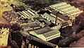
 Ardfinnan Woollen Mills building.jpg 2,431 × 1,960; 3.75 MB
-
 Ardfinnan Woollen Mills.jpg 1,241 × 707; 378 KB
-
 Castles of Munster - Ardfinnan, Tipperary (2) - geograph.org.uk - 1393369.jpg 1,024 × 683; 762 KB
-
 Castles of Munster, Ardfinnan, Tipperary - geograph.org.uk - 1393364.jpg 1,024 × 683; 975 KB
-
 Derelict cottage at Neddans - geograph.org.uk - 2717344.jpg 1,600 × 1,200; 584 KB
-
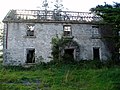
 Derelict farm building and house, Lacken - geograph.org.uk - 2717345.jpg 1,600 × 1,200; 447 KB
-
 Derelict house at Neddans, near Ardfinnan - geograph.org.uk - 2712361.jpg 1,600 × 1,200; 585 KB
-
 For the Gentlemen (8653686629).jpg 2,000 × 1,539; 1.47 MB
-
 Gateway to derelict buildings, Lacken - geograph.org.uk - 2717346.jpg 1,600 × 1,200; 596 KB
-
 Illustration of Prendergasts gristmill - Early 18th century.jpg 356 × 234; 95 KB
-

-
 River bridge at Ardfinnan - geograph.org.uk - 1368888.jpg 640 × 480; 93 KB
-
 Sports fields at Ardfinnan - geograph.org.uk - 1395105.jpg 640 × 480; 243 KB
-
 Welcome to Ardfinnan - geograph.org.uk - 4032558.jpg 1,024 × 768; 336 KB


.jpg)


.png)


