Category:Banks Islands
Jump to navigation
Jump to search
islands in Torba, Vanuatu  | |||||
| Upload media | |||||
| Instance of |
| ||||
|---|---|---|---|---|---|
| Location | Torba, Vanuatu | ||||
| Located in or next to body of water | |||||
| Area |
| ||||
| Elevation above sea level |
| ||||
 | |||||
Subcategories
This category has the following 7 subcategories, out of 7 total.
G
M
- Merelava (3 F)
- Merig Island (2 F)
- Mota Island (5 F)
- Mota Lava (4 F)
U
- Ureparapara Island (8 F)
V
Media in category "Banks Islands"
The following 24 files are in this category, out of 24 total.
-

-
 Admiralty Chart No 174 South West Pacific New Hebrides Islands, Banks Group, Published 1887.jpg 6,096 × 8,023; 10.11 MB
-
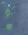 Banks Islands, Vanuatu, Sentinel-2.jpg 648 × 803; 72 KB
-
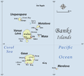
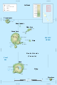 Banks Islands-en.svg 1,002 × 1,508; 323 KB
-
 Banks Islands-eo.svg 1,002 × 1,508; 323 KB
-
 Banks Islands-fr.svg 1,002 × 1,508; 323 KB
-
 Banks Islands-mk.svg 1,002 × 1,508; 323 KB
-
 BanksAndRowa Islands Map.png 505 × 499; 8 KB
-
 Distribuzione di Pteropus fundatus.tif 865 × 803; 1.99 MB
-
 ESC large ISS006 ISS006-E-26739.JPG 3,032 × 2,064; 911 KB
-
 FMIB 41416 Scene in Banks Islands.jpeg 1,469 × 881; 610 KB
-
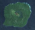 Gaua, Banks Islands, Sentinel-2.jpg 705 × 613; 91 KB
-
 ISS017-E-17936 - View of Earth.jpg 3,072 × 2,040; 724 KB
-
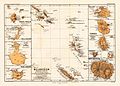 Melanesien (östliche Hälfte) 1870 Karte.jpg 2,372 × 1,700; 1.73 MB
-
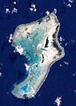
 Ravenga Landsat.jpg 155 × 219; 9 KB
-
 Rowa Islands ISS002.jpg 1,900 × 1,900; 321 KB
-
 Rowa Islands, Landsat.jpg 262 × 366; 39 KB
-
 Ureparapara Landsat.jpg 379 × 303; 50 KB
-
 Vanua Lava Landsat.jpg 940 × 979; 366 KB
-
 Vanua Lava, Banks Islands, Sentinel-2.jpg 691 × 809; 116 KB
-
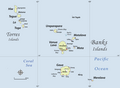 Vanuatu-Torres-Banks.png 1,025 × 750; 183 KB
-
 Vetaounde, Banks Islands, Sentinel-2.jpg 154 × 158; 23 KB
-
 Vetaounde.png 242 × 179; 72 KB
-
 Womtelo Map-Banks-Vanuatu 1000.png 1,001 × 900; 182 KB
.jpg)


_1870_Karte.jpg)


