Category:Cham (Oberpfalz)
Jump to navigation
Jump to search
municipality in Oberpfalz, Germany    | |||||
| Upload media | |||||
| Pronunciation audio | |||||
|---|---|---|---|---|---|
| Instance of |
| ||||
| Part of |
| ||||
| Location | Cham, Upper Palatinate, Bavaria, Germany | ||||
| Located in or next to body of water | |||||
| Head of government |
| ||||
| Population |
| ||||
| Area |
| ||||
| Elevation above sea level |
| ||||
| Different from | |||||
| official website | |||||
 | |||||
Subcategories
This category has the following 16 subcategories, out of 16 total.
!
A
B
C
D
E
G
H
- History of Cham (25 F)
J
- Christoph Janker (4 F)
- Judenstraße Cham (Oberpfalz) (3 F)
N
S
T
Pages in category "Cham (Oberpfalz)"
This category contains only the following page.
Media in category "Cham (Oberpfalz)"
The following 38 files are in this category, out of 38 total.
-
 Cham.svg 475 × 539; 15 KB
-
 Wappen Cham (Oberpfalz).png 600 × 669; 290 KB
-
 Wappen Stadt Cham.png 150 × 160; 71 KB
-
 Wappen von Cham.svg 710 × 773; 29 KB
-
 93413 Cham, Germany - panoramio.jpg 3,888 × 2,592; 842 KB
-
 Alte Eisenbahnbrücke - panoramio (2).jpg 4,320 × 3,240; 2.93 MB
-
 Bücherschrank Cham.jpg 3,456 × 4,608; 4.69 MB
-
 Cham - panoramio (10).jpg 5,456 × 3,064; 6.18 MB
-
 Cham - panoramio (11).jpg 3,064 × 4,596; 4.36 MB
-
 Cham banner.jpg 10,919 × 1,559; 14.3 MB
-
 Cham Stadt-neu.jpg 1,885 × 1,350; 794 KB
-
 Cham Szenenfilmband Bruecke 2006.jpg 1,538 × 1,020; 182 KB
-
 Cham, CHA - Kothmaißling v W, Hoher Bogen.jpg 4,489 × 2,481; 890 KB
-
 Cham, CHA - Loibling nw Ri SW - Regentalaue, Falkensteiner Vorwald 02.jpg 4,509 × 2,476; 692 KB
-

-
 Cham, CHA - Regenbogen v S, Straubinger Turm.jpg 4,488 × 2,481; 719 KB
-
 Cham, CHA - Weinberg Ri NW - Katzbach, Pemfling, CHA v SO.jpg 4,608 × 2,592; 1.02 MB
-
 Cham, srpen 2023.jpg 4,000 × 3,000; 3.49 MB
-
 Cham-Blick-Altstadt-01.JPG 4,592 × 2,576; 4.34 MB
-
 Cham-Regen.jpg 1,600 × 1,200; 485 KB
-
 Chamb Mündung.JPG 4,320 × 3,240; 3.01 MB
-
 ChamSteinmarktStJakob.jpg 3,000 × 4,000; 2.52 MB
-
 Climatediagram-metric-english-Cham-Germany-1961-1990.png 1,000 × 685; 67 KB
-
 Digitales Orthofoto von Cham (Bayerische Vermessungsverwaltung).tif 37,500 × 37,500; 2.16 GB
-
 Florian-Geyer-Brücke in Cham.jpg 3,264 × 2,448; 4.95 MB
-
 Fluss "Regen" in Cham, Oberpfalz.jpg 2,560 × 1,920; 3.33 MB
-
 Fluss "Regen" in Cham.jpg 2,463 × 1,847; 1.03 MB
-
 Fluss "Regen", Cham.jpg 3,020 × 2,264; 1.71 MB
-
 Häuser in Cham.jpg 3,264 × 2,448; 2.41 MB
-
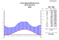 Klimadiagramm-metrisch-deutsch-Cham-Deutschland-1961-1990.png 1,000 × 685; 67 KB
-
 Landkreis Cham 1970.png 581 × 599; 25 KB
-
 Panorama der Stadt Cham.jpg 10,919 × 3,321; 26.11 MB
-
 Panorama-Lam.JPG 6,763 × 1,399; 1.25 MB
-
 Reste der Industriebahn - panoramio.jpg 4,320 × 3,240; 3.03 MB
-
 Runding, CHA - Burgruine - Gipfelfels Ri W - Cham, CHA, Cham-Further Senke 01.jpg 4,608 × 3,456; 1.69 MB
-
 Stadtmauer Cham Fenster nach Westen.jpg 3,000 × 4,000; 3 MB
-
 Stadtmauer Westen Cham.jpg 2,257 × 4,000; 2.82 MB
-
 Řezná, Kouba.jpg 4,912 × 2,703; 10.26 MB

.png)


.jpg)

.jpg)
.jpg)


