Category:Cycling infrastructure
Jump to navigation
Jump to search
facilities for use by cyclists  | |||||
| Upload media | |||||
| Subclass of | |||||
|---|---|---|---|---|---|
| Facet of |
| ||||
| Has use | |||||
| Has part(s) |
| ||||
| Different from | |||||
| |||||
Infrastructure related to enabling the movement and parking of bicycles. ![]() cycling
cycling
Subcategories
This category has the following 25 subcategories, out of 25 total.
Media in category "Cycling infrastructure"
The following 38 files are in this category, out of 38 total.
-
 1dir-car, 1-dir-cyc contr.png 500 × 500; 7 KB
-
 1dir-car, 2dir-cyc left.png 500 × 500; 7 KB
-
 1dir-car, 2dir-cyc re.png 500 × 500; 7 KB
-
 1dir-car, 2x 1dir-cyc.png 500 × 500; 7 KB
-
 1dir-car, bike 2dir.png 500 × 500; 6 KB
-
 1dir-car, free 1dir-cyc same left.png 500 × 500; 6 KB
-
 Anneler Günü 2013 - panoramio.jpg 3,264 × 2,448; 4.63 MB
-
 Apt - Aire de Cyclotourisme.jpg 4,608 × 3,072; 2.43 MB
-
 Bicycle parking, Altdorf bei Nürnberg (P1180292).jpg 4,564 × 3,043; 10.76 MB
-
 Bicycle parking, Altdorf bei Nürnberg (P1180293).jpg 4,608 × 3,456; 12.58 MB
-
 Bicycle-parking.jpg 2,048 × 1,152; 2.18 MB
-
 Bike Index registration spokecard.jpg 1,000 × 855; 336 KB
-
 BOAB.JPG 1,209 × 840; 151 KB
-
 Bus island on Whitelegg way next to Redhill Roundabout.jpg 4,624 × 3,472; 5.71 MB
-
 Byclex ramp Launcher.jpg 6,000 × 4,000; 6.7 MB
-
 Chodnik z trwałym oznaczniem dopuszczenia ruchu rowerowego.jpg 3,024 × 4,032; 9.12 MB
-
 Continuous pavement in Edinburgh.jpg 4,032 × 3,024; 3.67 MB
-
 FAHRRADFREUNDLICHER UMBAU.svg 661 × 379; 121 KB
-
 Figure 1 Examples of Cyclist Road Markings and Facilities (23917271266).jpg 2,273 × 2,041; 366 KB
-
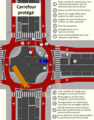 Fonctionnalités d'un carrefour protégé.png 919 × 1,173; 99 KB
-
 Henderson during Streets For People trial.jpg 4,032 × 2,268; 1.29 MB
-
 HK 屯門 Tuen Mun 海榮路 Hoi Wing Road bike parking Dec-2017 IX1 Loco.jpg 2,048 × 1,368; 1.87 MB
-
 Leinfelden-Echterdingen Haltestelle Stadionstraße.jpg 4,624 × 2,604; 5.31 MB
-

-

-

-
 Oznaczenie trwałe ciągu w którym dopuszczony jest ruch rowerów.jpg 3,024 × 4,032; 7.09 MB
-
 Pictograma ciclista en Av. 20 de Noviembre.jpg 2,448 × 3,264; 327 KB
-
 Pictograma de carril compartido en calle Miguel Hidalgo, Santiago de Querétaro.jpg 1,920 × 2,560; 606 KB
-
 Pyöräkellari.jpg 6,662 × 4,805; 4.81 MB
-
 Radroutenwegweiser Abzweigung St. Ulrich 2.jpg 4,032 × 3,024; 3.34 MB
-
 Rondo rowerowe w Gdańsku Przymorze.jpg 3,024 × 4,032; 11.49 MB
-
 Schlauchautomat Stadionstraße.jpg 4,624 × 2,604; 4.2 MB
-
 Separated cycle tracks on Whitelegg Way.jpg 3,470 × 3,472; 3.75 MB
-
 Señal de ciclovía en calle Invierno, 2022.jpg 2,448 × 3,264; 1.12 MB
-
 Wilhelm-Epstein-Str, Frankfurt am Main (P1090452).jpg 4,483 × 3,362; 13.08 MB
-
 WIMB.png 250 × 80; 7 KB
-
 Zona de adelantamiento en Avenida Constituyentes.jpg 3,264 × 2,448; 318 KB


.jpg)
.jpg)


.jpg)


.jpg)
.jpg)
.jpg)


.jpg)
