<nowiki>Kameng oriental; પૂર્વ કમેંગ જિલ્લો; East Kameng barrutia; East Kameng; Восточный Каменг; पूर्व कमेङ जिला; East Kameng district; بخش کامنگ شرقی; 东卡门县; ضلع چڑھدا کامنگ; مشرقی کامینگ ضلع; شرق كامنج; Districte d'East Kameng; पूर्वकमेङ्गमण्डलम्; पूर्व कमेंग जिला; తూర్పు కమెంగ్ జిల్లా; Itä-Kamengin piirikunta; পূব কামেং জিলা; East Kameng district; கிழக்கு காமெங் மாவட்டம்; distretto del Kameng Orientale; পূর্ব কামেং জেলা; district du Kameng-Oriental; पूर्व कामेंग जिल्हा; ପୂର୍ବ କାମେଙ୍ଗ ଜିଲ୍ଲା; Vzhodni Kameng; पूर्व कमेंग जिल्ला; East Kameng; East Kameng; East Kameng; East Kameng district; ᱥᱟᱢᱟᱝ ᱠᱟᱢᱮᱝ ᱦᱚᱱᱚᱛ; ഈസ്റ്റ് കംനേങ്ങ് ജില്ല; East Kameng; पूर्व कमेंग जिला; East Kameng district; شرق كامنج; 東カメン県; East Kameng; distrito del estado de Arunachal Pradesh, India; অরুণাচল প্রদেশের জেলা; district de l'Inde; distritu de la India; भारताच्या अरुणाचल प्रदेश राज्यातील जिल्हा.; Distrikt in Indien; ଅରୁଣାଚଳ ପ୍ରଦେଶର ଜିଲ୍ଲା, ଭାରତ; okraj indijske zvezne države Arunačal Pradeš; distrikt i India; അരുണാചല്പ്രദേശിലെ ജില്ല; district in India; అరుణాచల్ ప్రదేశ్ లోని జిల్లా; भारतीय राज्य अरुणाचल प्रदेश का एक जिला; ᱚᱨᱩᱬᱟᱪᱚᱲ ᱯᱨᱚᱫᱮᱥ ᱨᱮᱱᱟᱜ ᱦᱚᱱᱚᱛ, ᱥᱤᱧᱚᱛ; ভাৰতৰ অৰুণাচল প্ৰদেশৰ এখন জিলা; district of Arunachal Pradesh, India; भारतको एक जिल्ला हो; distretto indiano; அருணாசலப் பிரதேசத்தில் உள்ள மாவட்டம்; distritu d'East Kameng; East Kameng (distritu)</nowiki>
.svg)

 Arunachal Pradesh district location map East Kameng.svg 2,393 × 1,956; 261 KB
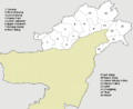 India Arunachal Pradesh districts English.PNG 734 × 600; 76 KB
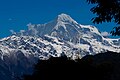 Katoie gyang kra daadi.jpg 2,233 × 1,485; 701 KB

