Category:Farchant
Jump to navigation
Jump to search

municipality in Bavaria, Germany    | |||||
| Upload media | |||||
| Instance of |
| ||||
|---|---|---|---|---|---|
| Part of |
| ||||
| Location | Garmisch-Partenkirchen, Upper Bavaria, Bavaria, Germany | ||||
| Located in or next to body of water | |||||
| Head of government |
| ||||
| Population |
| ||||
| Area |
| ||||
| Elevation above sea level |
| ||||
| official website | |||||
 | |||||
Subcategories
This category has the following 12 subcategories, out of 12 total.
B
- Boundary stones of Farchant (2 F)
E
G
H
M
- Maps of Farchant (7 F)
S
- Sports in Farchant (empty)
T
- Tunnel Farchant (2 F)
V
- Views of Farchant (4 F)
Media in category "Farchant"
The following 7 files are in this category, out of 7 total.
-
 Wappen von Farchant.png 1,785 × 1,835; 4.74 MB
-
 Wappen von Farchant.svg 1,760 × 1,820; 1.83 MB
-
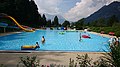
 2019-07-01 Freibad Farchant 01.jpg 3,840 × 2,160; 4.26 MB
-
 2019-07-01 Freibad Farchant 02.jpg 3,840 × 2,160; 4.08 MB
-
 2019-07-01 Freibad Farchant 03.jpg 3,840 × 2,160; 3.93 MB
-
 Farchant in GAP.svg 649 × 540; 1.31 MB
-
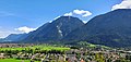 View from Werdenfels Castle to Garmisch-Partenkirchen 2.jpg 4,032 × 1,908; 2.03 MB


