Category:Fuchsmühl
Jump to navigation
Jump to search
municipality of Germany     | |||||
| Upload media | |||||
| Instance of |
| ||||
|---|---|---|---|---|---|
| Part of |
| ||||
| Location | Tirschenreuth, Upper Palatinate, Bavaria, Germany | ||||
| Population |
| ||||
| Area |
| ||||
| Elevation above sea level |
| ||||
| official website | |||||
 | |||||
Subcategories
This category has the following 4 subcategories, out of 4 total.
B
C
H
P
Media in category "Fuchsmühl"
The following 6 files are in this category, out of 6 total.
-
 Wappen von Fuchsmühl.svg 512 × 559; 13 KB
-
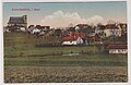 AK - Fuchsmühl - 1910.jpg 856 × 558; 59 KB
-
 Digitales Orthofoto von Fuchsmühl (Bayerische Vermessungsverwaltung).tif 12,500 × 17,500; 488.86 MB
-
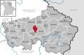 Fuchsmühl in TIR.svg 780 × 516; 594 KB
-
 Michael lindner.jpg 931 × 800; 185 KB
-
 Wappen Fuchsmuehl.png 150 × 160; 71 KB


