Category:Goes
Jump to navigation
Jump to search
Deutsch: Goes ist eine Gemeinde und Stadt in der Provinz Zeeland, im Südwesten der Niederlande. Es liegt in der Region Zuid-Beveland.
English: Goes is a municipality and city in the province of Zeeland, in the southwest of the Netherlands. It is located in the region of Zuid-Beveland.
Français : Goes est une commune et ville dans la province de Zélande, au sud-ouest des Pays-Bas. Elle est située dans la région de Zuid-Beveland.
Nederlands: Afbeeldingen van de gemeente Goes in de provincie Zeeland in het zuidwesten van Nederland. Het ligt in de regio Zuid-Beveland
municipality in Zeeland, the Netherlands    .svg)  | |||||
| Upload media | |||||
| Instance of |
| ||||
|---|---|---|---|---|---|
| Location | Zeeland, Netherlands | ||||
| Capital | |||||
| Head of government |
| ||||
| Inception |
| ||||
| Population |
| ||||
| Area |
| ||||
| Elevation above sea level |
| ||||
| Replaces |
| ||||
| official website | |||||
 | |||||
Subcategories
This category has the following 10 subcategories, out of 10 total.
Media in category "Goes"
The following 8 files are in this category, out of 8 total.
-
241 Goes.ogg 1.5 s; 25 KB
-
 AgeSexPyramid 2022 Goes.svg 560 × 400; 5 KB
-
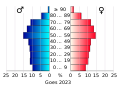 AgeSexPyramid 2023 Goes.svg 560 × 400; 5 KB
-
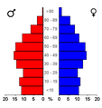 Bevolkingspiramide - Gemeente Goes (2007).png 350 × 370; 7 KB
-
CONCOURS HIPPIQUE-PGM4011944.webm 1 min 9 s, 720 × 576; 9.36 MB
-
 Gezicht op Goes Goes (titel op object), RP-P-AO-15-97-1.jpg 2,952 × 2,080; 1.09 MB
-
 Gezicht op Goes Goes aan de landtzyde (titel op object), RP-P-AO-15-97-2.jpg 2,980 × 2,274; 1.15 MB
-
 Westwal 41 Goes.jpg 800 × 600; 132 KB


.png)
,_RP-P-AO-15-97-1.jpg)
,_RP-P-AO-15-97-2.jpg)
