Category:Harwich
Jump to navigation
Jump to search
English: Harwich is a port and town in Essex, England.
Nederlands: Harwich is een havenstad in Essex, Engeland.
town in Essex, England   | |||||
| Upload media | |||||
| Instance of | |||||
|---|---|---|---|---|---|
| Location | Tendring, Essex, East of England, England | ||||
| Inception |
| ||||
| Population |
| ||||
| Different from | |||||
| Said to be the same as | Harwich (Wikimedia duplicated page, civil parish) | ||||
| official website | |||||
 | |||||
Subcategories
This category has the following 32 subcategories, out of 32 total.
B
- Beacon Hill Battery (7 F)
D
- Dovercourt Range Lights (37 F)
E
H
- Ha'penny Pier (16 F)
- St Nicholas' Church, Harwich (6 F)
- Harwich Foreshore (4 F)
- Harwich Guildhall (2 F)
- Harwich Lifeboat Museum (5 F)
- Harwich Redoubt (5 F)
L
M
- Maps of Harwich (14 F)
O
- Old Naval Yard Crane (6 F)
P
- Pier Hotel, Harwich (7 F)
S
- Shops in Harwich (2 F)
T
W
- Harwich in World War I (21 F)
- Harwich in World War II (25 F)
Media in category "Harwich"
The following 200 files are in this category, out of 398 total.
(previous page) (next page)-
 ECR(1851) p67 - (Harwich) Club House.jpg 985 × 871; 241 KB
-
 1953 Flood Victims Memorial - geograph.org.uk - 2427514.jpg 1,200 × 1,600; 485 KB
-
 20110527 Harwich 04.JPG 3,264 × 2,448; 912 KB
-
 20110527 Harwich 05.JPG 3,264 × 2,448; 795 KB
-
 A glimpse of Esplanade Hall from its back yard - geograph.org.uk - 5903428.jpg 1,024 × 768; 349 KB
-

-
 Alley from West St to Church St - geograph.org.uk - 5367727.jpg 5,202 × 3,465; 3.27 MB
-
 Anyone for cricket^ - geograph.org.uk - 4954425.jpg 640 × 480; 244 KB
-

-
 Arch under Marine Parade (from town) - geograph.org.uk - 4388053.jpg 640 × 480; 59 KB
-
 Arms and inscription on former school, Harwich (geograph 5903380).jpg 684 × 1,024; 218 KB
-
 Bank building, Dovercourt - geograph.org.uk - 5900431.jpg 1,024 × 768; 254 KB
-
 Beach and groynes at Dovercourt - geograph.org.uk - 4552786.jpg 1,920 × 1,080; 587 KB
-
 Beach and Navyard Wharf - geograph.org.uk - 5367794.jpg 5,202 × 3,465; 3.6 MB
-
 Beach below Beacon Hill, Harwich - geograph.org.uk - 5904207.jpg 1,024 × 768; 280 KB
-
 Beach huts 9 - 12, Dovercourt - geograph.org.uk - 5902103.jpg 1,024 × 684; 238 KB
-
 Beach huts and Low Lighthouse, Harwich - geograph.org.uk - 5904823.jpg 1,024 × 768; 210 KB
-
 Beach huts at Dovercourt - geograph.org.uk - 4917781.jpg 1,024 × 768; 147 KB
-
 Beach huts at Dovercourt - geograph.org.uk - 5367951.jpg 5,202 × 3,465; 2.41 MB
-
 Beach huts at Harwich Green - geograph.org.uk - 2565074.jpg 4,000 × 3,000; 2.53 MB
-

-
 Beach Patrol cabin, Dovercourt - geograph.org.uk - 5902107.jpg 1,024 × 684; 217 KB
-
 Beacon cliff defences and breakwater - geograph.org.uk - 5367829.jpg 5,202 × 3,465; 3.52 MB
-
 Beacon Hill Fort in Harwich (17334519062).jpg 4,300 × 2,848; 3.43 MB
-
 Beacon Hill Park bandstand - geograph.org.uk - 5370022.jpg 5,202 × 3,465; 4.99 MB
-
 Blue flag Café, Dovercourt - geograph.org.uk - 5902118.jpg 1,024 × 684; 225 KB
-
 Boarding the ferry - geograph.org.uk - 895355.jpg 640 × 480; 84 KB
-
 Boat on Harwich beach - geograph.org.uk - 749026.jpg 640 × 426; 67 KB
-
 Bobbit's Hole signs - geograph.org.uk - 5369257.jpg 5,202 × 3,465; 3.32 MB
-
 Bobbits Hole nature reserve - geograph.org.uk - 5369252.jpg 5,202 × 3,465; 5.23 MB
-
 Bottom of Hall Lane - geograph.org.uk - 5369056.jpg 5,202 × 3,465; 3.93 MB
-
 Breakwater - geograph.org.uk - 993815.jpg 640 × 480; 48 KB
-
 Breakwater below Beacon Cliff - geograph.org.uk - 5367833.jpg 5,202 × 3,465; 3.15 MB
-
 Breakwater off Beacon Cliff, Harwich - geograph.org.uk - 5900219.jpg 1,024 × 768; 244 KB
-
 Breakwater, Harwich - geograph.org.uk - 5369999.jpg 640 × 480; 42 KB
-
 Breakwater, Harwich - geograph.org.uk - 540665.jpg 640 × 480; 105 KB
-
 Breakwaters at Beacon cliff - geograph.org.uk - 5367824.jpg 5,202 × 3,465; 3.1 MB
-
 Bus depot, Harwich - geograph.org.uk - 5901333.jpg 1,024 × 684; 208 KB
-

-
 Chef outside Muppets Cafe - geograph.org.uk - 5369274.jpg 3,807 × 3,060; 1.63 MB
-
 Children's playground, Harwich - geograph.org.uk - 5370025.jpg 640 × 480; 76 KB
-
 Cliff hotel - geograph.org.uk - 5367922.jpg 5,202 × 3,465; 4.06 MB
-
 Clocktower at the junction of High St and Kingsway - geograph.org.uk - 5369341.jpg 3,465 × 5,202; 2.98 MB
-
 Coastal defences at Beacon Cliff - geograph.org.uk - 5367834.jpg 5,202 × 3,465; 3.88 MB
-
 Converted goods shed, Harwich Town - geograph.org.uk - 5901793.jpg 1,024 × 768; 264 KB
-
 Cottages on Main Road, Dovercourt - geograph.org.uk - 5369851.jpg 640 × 480; 57 KB
-
 Cranes at Felixstowe docks, from Dovercourt - geograph.org.uk - 6125853.jpg 1,024 × 768; 73 KB
-
 Currents Lane, Harwich - geograph.org.uk - 5902522.jpg 1,024 × 768; 309 KB
-
 Decorative pump outside Harwich Town station - geograph.org.uk - 5367671.jpg 5,202 × 3,465; 3.86 MB
-
 Demolished housing, Orwell Road - geograph.org.uk - 2484984.jpg 640 × 480; 67 KB
-
 Development of flats, Main Road - geograph.org.uk - 3827954.jpg 640 × 480; 60 KB
-

-
 Dovercourt beach - geograph.org.uk - 5367916.jpg 5,202 × 3,465; 3.91 MB
-
 Dovercourt beach and groynes - geograph.org.uk - 5367912.jpg 5,202 × 3,465; 3.51 MB
-
 Dovercourt boating lake - geograph.org.uk - 5367957.jpg 5,202 × 3,465; 4.16 MB
-
 Dovercourt Central Church - geograph.org.uk - 5369267.jpg 5,202 × 3,465; 2.33 MB
-
 Dovercourt Dock River at Parkeston - geograph.org.uk - 5892047.jpg 1,600 × 1,065; 849 KB
-
 Dovercourt fire station - geograph.org.uk - 1910468.jpg 640 × 427; 243 KB
-
 Dovercourt Lower lighthouse - geograph.org.uk - 5367932.jpg 5,202 × 3,465; 2.88 MB
-
 Dovercourt lower lighthouse seen through the upper. - geograph.org.uk - 5367937.jpg 5,202 × 3,465; 3.78 MB
-
 Dovercourt Railway Station - geograph.org.uk - 5893985.jpg 1,600 × 1,065; 527 KB
-
 Dovercourt station - geograph.org.uk - 5900476.jpg 1,024 × 768; 229 KB
-
 Dovercourt upper lighthouse - geograph.org.uk - 5367934.jpg 3,465 × 5,202; 2.89 MB
-
 DrillHall Harwich 01.jpg 2,592 × 1,936; 1.1 MB
-
 DrillHall Harwich 02.jpg 2,592 × 1,936; 1.8 MB
-
 Drinking fountain near Harwich Town station (geograph 7405073).jpg 4,000 × 5,000; 4.76 MB
-
 Drinking fountain, station forecourt - detail - geograph.org.uk - 5901468.jpg 1,024 × 684; 276 KB
-
 Dutch Attack on Harwich, July 1667 RMG BHC0296.tiff 6,277 × 4,578; 82.21 MB
-
 E Class Submarines (6694716283).jpg 623 × 480; 70 KB
-
 E07 (6694716291).jpg 878 × 487; 60 KB
-
 Elegant door and portal, Church Street, Harwich - geograph.org.uk - 2264337.jpg 691 × 1,024; 205 KB
-
 Elizabeth II postbox on Beach Road, Dovercourt - geograph.org.uk - 5377555.jpg 1,944 × 2,592; 1.01 MB
-
 Elizabeth II postbox on Main Road, Dovercourt - geograph.org.uk - 5377645.jpg 1,944 × 2,592; 1 MB
-
 Empty beach by the Essex Coast path - geograph.org.uk - 5367964.jpg 5,202 × 3,465; 3.47 MB
-
 Englandforensic2.jpg 4,320 × 2,880; 2.8 MB
-
 Environment Agency 110809 143655.jpg 4,288 × 2,848; 5.68 MB
-
 Esplanade Hall, Harwich - geograph.org.uk - 5905876.jpg 1,024 × 684; 245 KB
-
 Esplanade School (6619126097).jpg 1,166 × 1,144; 423 KB
-
 Esplanade School (6619126099).jpg 1,818 × 1,065; 467 KB
-
 Essex way looking northwards - geograph.org.uk - 5367909.jpg 5,202 × 3,465; 3.7 MB
-
 Essex Way looking southwards - geograph.org.uk - 5367971.jpg 5,202 × 3,465; 4.26 MB
-
 EssexArtilleryVols letter.jpg 413 × 499; 62 KB
-

-
 Explanatory plate on old postbox - geograph.org.uk - 5901758.jpg 684 × 1,024; 230 KB
-
 First Eastern National, Harwich Bus Depot - geograph.org.uk - 539637.jpg 640 × 480; 107 KB
-
 Fish, on a fence - geograph.org.uk - 5873694.jpg 1,000 × 747; 243 KB
-

-
 Flats on The Drive, Dovercourt - geograph.org.uk - 5369870.jpg 640 × 485; 77 KB
-
 Flickr - law keven - HBWE...Overload...lol..-O)).jpg 2,592 × 2,476; 820 KB
-
 Flood memorial (geograph 6440536).jpg 681 × 1,024; 228 KB
-
 Foreshore, Harwich - geograph.org.uk - 5904675.jpg 1,024 × 768; 322 KB
-
 Foreshore, Harwich - geograph.org.uk - 5904813.jpg 1,024 × 768; 314 KB
-
 Former railway shed, Harwich Town - geograph.org.uk - 5901459.jpg 1,024 × 684; 227 KB
-
 Former Wellington Inn, Harwich - geograph.org.uk - 5906026.jpg 1,024 × 768; 255 KB
-
 Fortifications, Beacon Hill, Harwich - geograph.org.uk - 5902364.jpg 1,024 × 684; 227 KB
-
 Fryatt Family (5519270969).jpg 2,333 × 1,599; 1.4 MB
-
 Funfair on Harwich Green - geograph.org.uk - 5873688.jpg 1,024 × 768; 162 KB
-
 Furniture Store and Tea Room, Dovercourt - geograph.org.uk - 5369320.jpg 5,202 × 3,465; 3.72 MB
-
 George V postbox on Fronk's Road, Dovercourt - geograph.org.uk - 5377563.jpg 1,567 × 2,383; 907 KB
-
 George V postbox on Main Road, Dovercourt - geograph.org.uk - 5377662.jpg 1,537 × 2,592; 956 KB
-
 Ghostwriting - geograph.org.uk - 5194945.jpg 768 × 1,024; 291 KB
-
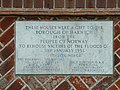 Gift from Norway - geograph.org.uk - 729277.jpg 640 × 480; 124 KB
-

-
 Government House, Harwich - geograph.org.uk - 5904860.jpg 1,024 × 768; 278 KB
-
 Government House, St Helen's Green - geograph.org.uk - 1225876.jpg 640 × 480; 89 KB
-
 Green at junction of Barrack Lane and Main Road - geograph.org.uk - 5370033.jpg 4,961 × 3,153; 4.14 MB
-
 Groynes - geograph.org.uk - 5367959.jpg 5,202 × 3,465; 3.76 MB
-
 H.M.S. Undaunted at Harwich - 2004 CSK 09856 0460 (080232).jpg 512 × 373; 32 KB
-
 Halfpenny Pier, Harwich - geograph.org.uk - 4204085.jpg 640 × 480; 81 KB
-
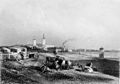 Harwich (Finden, Gutenberg).jpg 574 × 402; 48 KB
-
 Harwich , view from Shotley Marina - geograph.org.uk - 6158934.jpg 1,024 × 627; 551 KB
-

-
 Harwich - Electric Palace Cinema - geograph.org.uk - 4652904.jpg 1,024 × 768; 147 KB
-
 Harwich - Former Great Eastern Hotel - geograph.org.uk - 4652914.jpg 1,024 × 768; 174 KB
-
 Harwich - Historic Treadwheel Crane - geograph.org.uk - 4652902.jpg 1,024 × 768; 176 KB
-
 Harwich - Panorama - The Doll's House.jpg 15,552 × 3,808; 31.93 MB
-
 Harwich Alexandra Road - Greater Anglia 321360.JPG 1,024 × 768; 425 KB
-
 Harwich and Parkeston Football Club - geograph.org.uk - 5369249.jpg 5,202 × 3,465; 2.85 MB
-
 Harwich beach - geograph.org.uk - 4386805.jpg 640 × 480; 63 KB
-
 Harwich boot gestrand, Bestanddeelnr 902-1796.jpg 2,904 × 2,852; 1.46 MB
-
 Harwich Catholic School (6619085659).jpg 1,096 × 634; 106 KB
-
 Harwich church - geograph.org.uk - 5903384.jpg 1,024 × 768; 216 KB
-
 Harwich church from Church Lane - geograph.org.uk - 5903484.jpg 768 × 1,024; 285 KB
-
 Harwich County High School (6619126111).jpg 1,132 × 656; 216 KB
-
 Harwich County High School (6653446495).jpg 960 × 351; 55 KB
-
 Harwich County High School (6653446503).jpg 960 × 415; 62 KB
-
 Harwich County Primary (6619126113).jpg 297 × 171; 13 KB
-
 Harwich County Primary (6619174939).jpg 1,024 × 768; 455 KB
-
 Harwich County Primary (6660895437).jpg 1,024 × 768; 658 KB
-
 Harwich County Primary (6660895439).jpg 1,024 × 768; 429 KB
-
 Harwich County Primary School (6660926553).jpg 912 × 684; 547 KB
-
 Harwich County Primary School (6660926571).jpg 720 × 480; 71 KB
-
 Harwich Flood Memorial - geograph.org.uk - 5425700.jpg 3,183 × 4,333; 1.12 MB
-
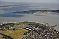
 Harwich from Landguard - geograph.org.uk - 5635898.jpg 1,024 × 768; 667 KB
-
 Harwich from Shotley Gate - geograph.org.uk - 3937227.jpg 800 × 600; 81 KB
-
 Harwich Harbour 1804.png 2,498 × 3,331; 1,012 KB
-
 Harwich Harbour reportofcommissi00grea 1 0033.jpg 7,495 × 4,551; 1.67 MB
-
 Harwich old fire station (geograph 1910471).jpg 640 × 427; 261 KB
-
 Harwich Police Station - geograph.org.uk - 5370042.jpg 5,202 × 3,465; 3.02 MB
-
 Harwich Police Station - geograph.org.uk - 5894271.jpg 1,600 × 1,065; 684 KB
-
 Harwich Port - geograph.org.uk - 2134284.jpg 1,600 × 1,067; 445 KB
-
 Harwich promenade - geograph.org.uk - 92329.jpg 480 × 640; 75 KB
-
 Harwich School (6653344263).jpg 1,024 × 768; 526 KB
-
 Harwich Skyline - geograph.org.uk - 6231521.jpg 3,440 × 2,288; 1.61 MB
-
 Harwich Skyline - geograph.org.uk - 6231529.jpg 3,396 × 977; 812 KB
-
 Harwich Town Crier, Ha'penny Pier - geograph.org.uk - 5425867.jpg 1,320 × 1,963; 408 KB
-
 Harwich Town railway station - geograph.org.uk - 3368389.jpg 1,024 × 768; 188 KB
-
 Harwich Town Railway Station - geograph.org.uk - 5894406.jpg 1,600 × 1,065; 514 KB
-
 Harwich Town Railway Station - geograph.org.uk - 5894410.jpg 1,600 × 1,065; 769 KB
-
 Harwich Town Railway Station - geograph.org.uk - 5894420.jpg 1,600 × 1,065; 685 KB
-
 Harwich Town Sailing Club (geograph 6440529).jpg 681 × 1,024; 139 KB
-
 Harwich Town station - geograph.org.uk - 5367669.jpg 4,496 × 3,137; 2.95 MB
-
 Harwich Town station - geograph.org.uk - 5901512.jpg 1,024 × 684; 184 KB
-
 Harwich Town station building - geograph.org.uk - 5367673.jpg 5,202 × 3,465; 4.41 MB
-
 Harwich Town station platform - geograph.org.uk - 5901778.jpg 1,024 × 768; 250 KB
-
 Harwich Turkish barber - geograph.org.uk - 5369990.jpg 4,288 × 3,175; 3.18 MB
-
 Harwich, Essex (16737433213).jpg 4,300 × 2,848; 3.75 MB
-
 Harwich, Radar Station - panoramio.jpg 900 × 600; 292 KB
-
 Harwich, UK - panoramio (1).jpg 4,608 × 2,592; 5.89 MB
-
 Harwich, UK - panoramio - tomasz kulawinski.jpg 4,608 × 2,592; 5.5 MB
-
 Harwich, UK - panoramio.jpg 4,608 × 2,592; 5.72 MB
-
 Harwich- Angelgate Cottages (geograph 6420093).jpg 1,024 × 576; 155 KB
-
 Harwich- The Naval House (geograph 6417767).jpg 1,024 × 556; 140 KB
-
 Harwich.jpg 590 × 394; 169 KB
-
 HH-AU102H-1 060819 CPS.jpg 6,000 × 4,000; 4.82 MB
-
 High lighthouse from Essex Way - geograph.org.uk - 5367797.jpg 5,202 × 3,465; 3.1 MB
-
 High Lighthouse, Dovercourt - geograph.org.uk - 5369879.jpg 640 × 480; 44 KB
-
 Hoarding in Market Street - geograph.org.uk - 5371362.jpg 640 × 480; 202 KB
-
 Home Bargains, Harwich - geograph.org.uk - 5370529.jpg 640 × 480; 60 KB
-
 Hotel Continental (closed) Dovercourt - geograph.org.uk - 5902244.jpg 1,024 × 768; 227 KB
-
 House on Eastgate Street, Harwich (geograph 5903729).jpg 768 × 1,024; 239 KB
-
 House on George Street, Harwich - geograph.org.uk - 5901713.jpg 953 × 1,024; 302 KB
-
 House on Kings Head Street, Harwich (geograph 5903723).jpg 1,024 × 1,024; 265 KB
-
 House on Main Road, Dovercourt - geograph.org.uk - 5369846.jpg 640 × 480; 86 KB
-
 Houses from Mill Lane - geograph.org.uk - 4388651.jpg 640 × 480; 61 KB
-
 Houses on Cliff Road, Dovercourt - geograph.org.uk - 5902277.jpg 1,024 × 1,024; 400 KB
-
 Houses on Hankin Avenue, Dovercourt - geograph.org.uk - 5369806.jpg 640 × 480; 73 KB
-
 Houses on Harbour Crescent, Harwich - geograph.org.uk - 5370014.jpg 640 × 480; 64 KB
-
 Houses on Main Road, Dovercourt - geograph.org.uk - 5369817.jpg 640 × 392; 56 KB
-
 Houses on Marine Parade, Dovercourt - geograph.org.uk - 4904420.jpg 1,024 × 768; 108 KB
-
 Huts and Maritime Museum, Harwich - geograph.org.uk - 5370018.jpg 640 × 480; 54 KB
-
 Just Florence Tea Room and Gift Shop, Church St - geograph.org.uk - 5370083.jpg 3,873 × 2,748; 2.71 MB
-
 Key Cutting Shop - geograph.org.uk - 5194998.jpg 768 × 1,024; 195 KB
-
 Kings Arms, Dovercourt - geograph.org.uk - 5369998.jpg 5,202 × 3,465; 3.11 MB
-
 Kings Arms, High Street, Dovercourt - geograph.org.uk - 5894259.jpg 1,179 × 1,600; 548 KB
-
 Lake at Dovercourt - geograph.org.uk - 4954433.jpg 640 × 480; 277 KB
-
 Lakes by the Essex Way - geograph.org.uk - 5367968.jpg 5,202 × 3,465; 3.94 MB
-
 Lidl at St Nicholas Roundabout - geograph.org.uk - 5893918.jpg 1,600 × 1,065; 573 KB
-
 Lifeboat Museum - geograph.org.uk - 2420508.jpg 640 × 444; 93 KB
-
 Lightship moored in Harwich Harbour - geograph.org.uk - 6097241.jpg 5,753 × 3,835; 2.07 MB
-
 Lookouts, Harwich (geograph 5905886).jpg 1,024 × 768; 271 KB
-
 Lorenzo Magalotti - Harwich 22530730580.jpg 950 × 697; 79 KB
-
 Marine Parade cliff - geograph.org.uk - 4388678.jpg 640 × 480; 76 KB
-
 Masonic Hall on Main Road, Harwich - geograph.org.uk - 5894324.jpg 1,600 × 1,065; 510 KB
-
 Masonic Hall, Harwich - geograph.org.uk - 5370055.jpg 5,202 × 3,465; 3.61 MB
-
 Masonic Hall, Harwich - geograph.org.uk - 5901289.jpg 1,024 × 768; 233 KB
-
 Mayflower Primary School - geograph.org.uk - 5900266.jpg 1,024 × 684; 221 KB
-
 Memorial 1953 Floods Harwich (6120927514).jpg 3,038 × 2,270; 3 MB
-
 Michaelstow Hall - panoramio.jpg 2,048 × 1,536; 797 KB
-

_p67_-_(Harwich)_Club_House.jpg)


_-_geograph.org.uk_-_4388038.jpg)
_-_geograph.org.uk_-_4388053.jpg)
.jpg)


_-_geograph.org.uk_-_4652881.jpg)


.jpg)

.jpg)
.jpg)


.jpg)
.jpg)


).jpg)
.jpg)


.jpg)


,_W_H_Woodhouse,_Esqr._Published_in_Hunt%27s_Yachting_Magazine_December_1853_RMG_PU6550.jpg)


.jpg)

.jpg)


.jpg)


.jpg)
.jpg)
.jpg)
.jpg)
.jpg)
.jpg)
.jpg)
.jpg)


.jpg)


.jpg)


.jpg)


.jpg)

.jpg)


.jpg)
.jpg)


_Dovercourt_-_geograph.org.uk_-_5902244.jpg)
.jpg)

.jpg)


.jpg)


.jpg)


.jpg)
.jpg)