Category:Hattem
Jump to navigation
Jump to search
| Camera location | | View all coordinates using: OpenStreetMap |
|---|
city and municipality in Gelderland, the Netherlands    .png) | |||||
| Upload media | |||||
| Spoken text audio | |||||
|---|---|---|---|---|---|
| Pronunciation audio | |||||
| Instance of |
| ||||
| Location | Gelderland, Netherlands | ||||
| Located in or next to body of water | |||||
| Population |
| ||||
| Area |
| ||||
| Elevation above sea level |
| ||||
| official website | |||||
 | |||||
Subcategories
This category has the following 19 subcategories, out of 19 total.
- Hattem in art (57 F)
B
- Begraafplaats Hattem (3 F)
C
- Cannons in Hattem (2 F)
H
J
- Jewish cemetery, Hattem (8 F)
M
S
- Spaanse Graven (Hattem) (13 F)
- Station Hattem (3 F)
- Symbols of Hattem (6 F)
T
V
- Vestingmuur Hattem (22 F)
W
- Water Sports in Hattem (3 F)
Media in category "Hattem"
The following 49 files are in this category, out of 49 total.
-
088 Hattem.ogg 0.9 s; 18 KB
-
 A.bovenlicht - Hattem - 20103332 - RCE.jpg 959 × 1,200; 185 KB
-
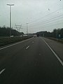
 A50 bij Wezep.jpg 4,068 × 2,923; 1.75 MB
-
 Bevolkingspiramide - Gemeente Hattem (2007).png 350 × 370; 7 KB
-
 Bos (30932108385).jpg 3,872 × 2,592; 4.87 MB
-

-
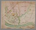 Caerte vande stadt en schependom van Hattem, mitsgaders de nieuw uijtgegeven heetvelden.jpg 3,712 × 3,124; 2.34 MB
-
 Depiction of the events occurring in the Netherlands in 1672.jpg 1,476 × 1,157; 1.04 MB
-
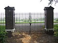 Gesloten hek (31236876606).jpg 4,000 × 3,000; 2.54 MB
-
 Hattem location.gif 600 × 371; 38 KB
-
 Hattem, Markt 1. (actm.) 01.jpg 3,139 × 4,323; 10.82 MB
-
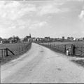
 Hattem, Netherlands - panoramio (10).jpg 2,048 × 1,375; 396 KB
-
 Hattem, Netherlands - panoramio (11).jpg 2,048 × 1,375; 408 KB
-
 Hattem, Netherlands - panoramio (13).jpg 2,048 × 1,375; 307 KB
-
 Hattem, Netherlands - panoramio (21).jpg 2,048 × 1,148; 263 KB
-
 Hattem, Netherlands - panoramio (37).jpg 2,048 × 1,155; 503 KB
-
 Hattem, Netherlands - panoramio (40).jpg 2,048 × 1,155; 800 KB
-
 Hattem, Netherlands - panoramio (41).jpg 2,048 × 1,155; 684 KB
-
 Hattem, Netherlands - panoramio (42).jpg 2,048 × 1,155; 537 KB
-
 Hattem, Netherlands - panoramio.jpg 899 × 1,600; 242 KB
-
 Hattem20994.jpg 4,288 × 2,848; 6.2 MB
-
 HattemDikkeTinne2023.jpg 5,472 × 3,648; 8.61 MB
-
 Hattemse Mixed Hockey Club.jpg 2,939 × 3,348; 1.07 MB
-
 Huis Yrst.jpg 465 × 359; 29 KB
-
 Lambert-van-den-Bos-Lieuwe-van-Aitzema-Historien-onses-tyds MGG 0404.tif 4,121 × 3,556; 41.96 MB
-
Nl-Hattem.ogg 1.3 s; 16 KB
-
 Op weg naar groningen - panoramio.jpg 1,536 × 2,048; 984 KB
-
 Over vanuit het zuiden - Hattem - 20103063 - RCE.jpg 1,200 × 959; 258 KB
-
 Overzicht - Hattem - 20103075 - RCE.jpg 1,200 × 797; 191 KB
-
 Overzicht Gaedsberg - Hattem - 20103424 - RCE.jpg 1,190 × 1,200; 316 KB
-
 Overzicht Gaedsberg - Hattem - 20103425 - RCE.jpg 1,190 × 1,200; 343 KB
-
 Overzicht Gaedsberg - Hattem - 20103426 - RCE.jpg 1,200 × 1,195; 356 KB
-

-
 Overzicht met Stadsgracht - Hattem - 20103381 - RCE.jpg 1,200 × 778; 299 KB
-
 Overzicht vanuit het oosten (Hoenswaard) - Hattem - 20103064 - RCE.jpg 1,200 × 1,200; 269 KB
-
 Pand, schilderijtje in bezit van Museum Hattem - Hattem - 20103294 - RCE.jpg 832 × 1,200; 224 KB
-
 Passantenhaven - Hattem - 20360670 - RCE.jpg 1,200 × 783; 183 KB
-

-
 Schouw in keuken - Hattem - 20103292 - RCE.jpg 969 × 1,200; 185 KB
-
 Stenen pomp - Hattem - 20319277 - RCE.jpg 807 × 1,200; 161 KB
-
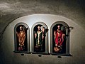 Three Saints in a cellar (36328806681).jpg 4,160 × 3,120; 2.44 MB
-
 Tuinhuisje - Hattem - 20103346 - RCE.jpg 1,195 × 1,200; 356 KB
-
 Tuinhuisje - Hattem - 20103347 - RCE.jpg 1,192 × 1,200; 407 KB
-
 Unnamed1 - panoramio (263).jpg 1,148 × 2,048; 349 KB
-
 Unnamed1 - panoramio (264).jpg 2,048 × 1,148; 351 KB
-
 Voermanskoepeltje - Hattem - 20103421 - RCE.jpg 1,200 × 1,200; 428 KB
-
 Voermanskoepeltje - Hattem - 20103422 - RCE.jpg 1,192 × 1,200; 419 KB
-
 Voermanskoepeltje - Hattem - 20103423 - RCE.jpg 1,190 × 1,200; 389 KB
-
 Zogeheten "Mariabeuk" (31276321986).jpg 3,000 × 4,000; 5.07 MB


.png)
.jpg)


.jpg)

_01.jpg)
.jpg)
.jpg)
.jpg)
.jpg)
.jpg)
.jpg)
.jpg)
.jpg)


_-_Hattem_-_20103064_-_RCE.jpg)


.jpg)


.jpg)
.jpg)


.jpg)