Category:Imeri Gramvousa
Jump to navigation
Jump to search
| Object location | | View all coordinates using: OpenStreetMap |
|---|
Deutsch: Imeri Gramvousa, Felseninsel vor der Nordwestküste von Kreta, Griechenland
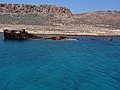
Français : Imeri Gramvousa (Ήμερη Γραμβούσα, « Gramvoussa calme ») est une île au nord-ouest de la Crète, à la point de la péninsule de Gramvousa. A la fin du XVIe siècle, les Vénitiens construisent une forteresse sur l'île ; reconstruite en 1630, elle est prise par les Turcs en 1691. L'épave du cargo Dimitrios P. est échouée sur la côte de l'île depuis 1968.
island in Crete, Greece  | |||||
| Upload media | |||||
| Instance of | |||||
|---|---|---|---|---|---|
| Part of | |||||
| Location |
| ||||
| Located in or next to body of water | |||||
| Width |
| ||||
| Length |
| ||||
| Population |
| ||||
| Area |
| ||||
 | |||||
Subcategories
This category has the following 3 subcategories, out of 3 total.
Media in category "Imeri Gramvousa"
The following 47 files are in this category, out of 47 total.
-
 20190623 105948c Ήμερη Γραμβούσα.jpg 4,032 × 2,268; 1.06 MB
-
 20190623 132542c Ήμερη Γραμβούσα.jpg 4,032 × 2,268; 963 KB
-
 Agave americana in Gramvousa (Crete).jpg 2,048 × 1,365; 1,000 KB
-
 Garabuse - Dapper Olfert - 1688.jpg 800 × 703; 265 KB
-
 Gramvousa - panoramio (14).jpg 4,000 × 3,000; 3.85 MB
-
 Gramvousa - panoramio (20).jpg 4,000 × 3,000; 4.22 MB
-
 Gramvousa - panoramio (24).jpg 4,000 × 3,000; 4.05 MB
-
 Gramvousa - panoramio (26).jpg 4,000 × 3,000; 4.4 MB
-
 Gramvousa - panoramio (4).jpg 4,000 × 3,000; 4.11 MB
-
 Gramvousa - panoramio (5).jpg 4,000 × 3,000; 4.22 MB
-
 Gramvousa - panoramio (7).jpg 4,000 × 3,000; 4.15 MB
-
 Gramvousa - panoramio (9).jpg 4,000 × 3,000; 4.14 MB
-
 Gramvousa island in Greece.jpg 2,896 × 1,846; 2.52 MB
-
 Gramvousa Island, Greece (Northwestern Crete). Seen from the Venetian fort (1).jpg 3,948 × 2,960; 9.57 MB
-

-
 Gramvousa Island, Greece (Northwestern Crete). Seen from the Venetian fort (3).jpg 3,968 × 2,976; 10.13 MB
-
 Gramvousa Island, Greece (Northwestern Crete). Seen from the Venetian fort (4).jpg 3,601 × 2,517; 6.9 MB
-
 Gramvousa Island, Greece (Northwestern Crete).jpg 3,968 × 2,976; 4.65 MB
-
 Gramvousa, Crete. - panoramio.jpg 4,912 × 3,264; 6.66 MB
-
 Gramvousa. View from the walls.jpg 1,000 × 750; 454 KB
-
 Imeri Gramvousa 02.JPG 3,996 × 2,998; 1.54 MB
-
 Imeri Gramvousa 03.JPG 3,995 × 2,995; 2.5 MB
-
 Imeri Gramvousa 04.JPG 4,217 × 3,162; 2.84 MB
-
 Imeri Gramvousa 05.JPG 4,189 × 3,142; 2.19 MB
-
 Imeri Gramvousa 06.JPG 4,188 × 3,143; 2.56 MB
-
 Imeri Gramvousa 07.JPG 4,199 × 3,150; 2.25 MB
-
 Imeri Gramvousa 08.JPG 4,208 × 3,154; 2.89 MB
-
 Imeri Gramvousa 09.JPG 4,117 × 3,086; 8.74 MB
-
 Imeri Gramvousa 10.JPG 3,937 × 2,954; 2.16 MB
-
 Imeri Gramvousa 11.JPG 4,221 × 3,166; 2.19 MB
-
 Imeri Gramvousa 12.JPG 4,198 × 3,151; 3.6 MB
-
 Imeri Gramvousa 13.JPG 4,167 × 3,127; 2.1 MB
-
 Imeri Gramvousa 14.JPG 3,771 × 2,829; 1.02 MB
-
 Imeri Gramvousa 15.JPG 4,119 × 3,090; 6.35 MB
-
 Imeri Gramvousa 16.JPG 4,209 × 3,161; 3.27 MB
-
 Kreta - Blick auf Gramvousa von Imeri Gramvousa.jpg 9,053 × 3,086; 10.44 MB
-
 Pevnost Ramvousa - panoramio - Effenberger.jpg 2,592 × 1,944; 1.34 MB
-
 Plants at Gramvousa island.jpg 2,048 × 1,365; 1.05 MB
-
 Ramvousa - panoramio.jpg 2,592 × 1,944; 1.34 MB
-
 Succulents - Gramvousa Island.jpg 2,048 × 1,365; 1.42 MB
-
 Succulents at Gramvousa.jpg 2,048 × 1,365; 1.03 MB
-
 View from Old Venetian Fort (Imeri Gramvousa, Crete, Greece).jpg 3,264 × 2,448; 3.32 MB
-
 ΓΡΑΜΒΟΥΣΑ ΘΕΑ ΑΠΟ ΨΗΛΑ (1).jpg 4,288 × 3,216; 5.79 MB
-
 ΓΡΑΜΒΟΥΣΑ ΘΕΑ ΑΠΟ ΨΗΛΑ (2).jpg 4,288 × 3,216; 6.74 MB
-
 ΓΡΑΜΒΟΥΣΑ ΤΑ ΠΛΟΙΑ ΠΕΘΕΝΟΥΝ ΣΤΑ ΛΙΜΑΝΙΑ.jpg 4,288 × 3,216; 6.68 MB
-
 Η Γραμβούσα από ψηλά.jpg 2,722 × 1,956; 1.18 MB
-
 Ναυάγιο, ήμερη Γραμβούσα.jpg 3,648 × 2,736; 2.11 MB


.jpg)

.jpg)
.jpg)
.jpg)
.jpg)
.jpg)
.jpg)
.jpg)
.jpg)

._Seen_from_the_Venetian_fort_(1).jpg)
._Seen_from_the_Venetian_fort_(2).jpg)
._Seen_from_the_Venetian_fort_(3).jpg)
._Seen_from_the_Venetian_fort_(4).jpg)
.jpg)


.jpg)
.jpg)
.jpg)


