Category:Khitrovka
Jump to navigation
Jump to search

Хитровская площадь и окрестности (аннотированное фото). Cм. тот же вид, снятый в 1916 году.
place in Basmanny District, Central Administrative Okrug, Moscow, Russia  | |||||
| Upload media | |||||
| Instance of |
| ||||
|---|---|---|---|---|---|
| Location | Basmanny District, Central Administrative Okrug, Moscow, Russia | ||||
| Founded by |
| ||||
| Different from | |||||
 | |||||
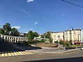
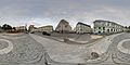
Русский: Хитровская площадь (Хитров рынок, Хитровка) в центре Москвы располагалась на перекрестке Подколокольного, Певческого и Петропавловского переулков (между улицей Солянка и Яузским бульваром). Память о Хитровке сохраняется в названии Хитровского переулка.
English: former Khitrov Market, the social bottom of Moscow in 1861-1918, was located at the crossing of Podkolokolny, Pevchesky and Petropavlovsky lanes (between Solyanka Street and Yauzsky Boulevard). Khitrovsky Lane is still present on the map of Moscow.
Subcategories
This category has the following 18 subcategories, out of 18 total.
!
- Historical images of Khitrovka (22 F)
- Historical maps of Khitrovka (3 F)
B
C
K
M
P
S
T
Y
- Yaroshenko house, Khitrovka (19 F)
Media in category "Khitrovka"
The following 74 files are in this category, out of 74 total.
-
 Basmanny, Moscow 2019 - 7139.jpg 4,032 × 3,024; 2.46 MB
-
 Basmanny, Moscow 2019 - 7141.jpg 4,032 × 3,024; 2.49 MB
-
 Basmanny, Moscow 2019 - 7145.jpg 4,032 × 3,024; 1.99 MB
-
 Basmanny, Moscow 2019 - 7153.jpg 4,032 × 3,024; 3.2 MB
-
 Basmanny, Moscow 2019 - 7161.jpg 4,032 × 3,024; 2.75 MB
-
 Basmanny, Moscow 2019 - 7165.jpg 4,032 × 3,024; 3.33 MB
-
 Basmanny, Moscow 2019 - 7167.jpg 4,032 × 3,024; 2.06 MB
-
 Basmanny, Moscow 2019 - 7171.jpg 4,032 × 3,024; 2.85 MB
-
 Basmanny, Moscow 2019 - 7173.jpg 4,032 × 3,024; 2.99 MB
-
 Basmanny, Moscow 2019 - 7176.jpg 4,032 × 3,024; 3.11 MB
-
 Basmanny, Moscow 2019 - 7178.jpg 4,032 × 3,024; 3.6 MB
-
 Basmanny, Moscow 2019 - 7180.jpg 4,032 × 3,024; 3.85 MB
-
 Basmanny, Moscow 2019 - 7182.jpg 4,032 × 3,024; 2.73 MB
-
 Basmanny, Moscow 2019 - 7185.jpg 4,032 × 3,024; 3.25 MB
-
 Hitrovskaya square PANO 20150910 183647.jpg 9,728 × 4,864; 10.28 MB
-
 Khitrovka - criminal district of the past - Moscow, Russia - panoramio.jpg 1,284 × 1,671; 514 KB
-
 Khitrovka 2023-07 1688833512.tif 3,872 × 2,592; 13.37 MB
-
 Khitrovka 2023-07 1688833530.tif 3,872 × 2,592; 14.54 MB
-
 Khitrovka school.JPG 2,304 × 1,456; 901 KB
-
 Moscow, Khitrovskaya Square (30727845293).jpg 3,264 × 2,178; 822 KB
-
 Moscow, Khitrovskaya Square (31498833676).jpg 3,264 × 2,178; 811 KB
-
 Moscow, Khitrovskaya Square green - 7155.jpg 4,032 × 3,024; 3.92 MB
-
 Moscow, Khitrovskaya Square green - 7157.jpg 4,032 × 3,024; 4.26 MB
-
 Moscow, Khitrovsky Lane 3-1 str.3 and 2-8 str.5 - 7184.jpg 4,032 × 3,024; 3.4 MB
-
 Moscow, Pevchesky 1-2C2B Apr 2008 02.JPG 1,200 × 1,200; 813 KB
-
 Moscow, Pevchesky 1-2C2B May 2008 03.JPG 1,200 × 1,500; 567 KB
-
 Moscow, Podkolokolny 16-5, medical school.jpg 1,344 × 1,778; 780 KB
-
 Moscow, Podkolokolny Lane 13-5 - 7233.jpg 3,024 × 4,032; 2.68 MB
-
 Moscow, Podkolokolny Lane approaching Khitrovskaya Square - 7127.jpg 3,024 × 4,032; 2.33 MB
-
 Moscow, Podkolokolny Lane approaching Khitrovskaya Square - 7129.jpg 4,032 × 3,024; 2.55 MB
-
 Orlov alms house.jpg 550 × 353; 114 KB
-
 Podkolokolny 10 02 (crop).jpg 1,027 × 751; 496 KB
-
 Podkolokolny 10 02.jpg 1,793 × 1,170; 607 KB
-
 Podkolokolny 11A school demolition Jan 2010 01.jpg 1,457 × 1,500; 560 KB
-
 Podkolokolny 11A school demolition Jan 2010 03.jpg 1,125 × 1,500; 479 KB
-
 Podkolokolny 11A school demolition Jan 2010 09.jpg 1,125 × 1,500; 383 KB
-
 А. П. Чехов.jpg 656 × 800; 66 KB
-
 Австралийское посольство.jpg 1,431 × 1,114; 369 KB
-
 Александр Андреевич Карзинкин.jpg 583 × 848; 61 KB
-
 Андрей Александрович Карзинкин.JPG 951 × 1,115; 195 KB
-
 В. Маяковский. Мясницкая часть.jpg 468 × 459; 118 KB
-
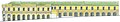
 Восточная сторона Хитровской площади.jpg 800 × 180; 54 KB
-
 Герб рода Хитрово на его собственном доме.JPG 1,041 × 892; 233 KB
-
 Главный дом усадьбы Лопухиных.JPG 814 × 703; 382 KB
-
 Д. Кувшинников.jpg 297 × 510; 68 KB
-
 Дом "Утюг", описанный в книге "Москва и москвичи", во в - panoramio.jpg 3,648 × 2,736; 2.32 MB
-
 Дом генерал-майора Н.З. Хитрово.2009.JPG 2,800 × 2,056; 1.97 MB
-
 Дом княгини Н.с. Щербатовой в Москве.jpg 1,373 × 1,140; 677 KB
-
 Дом Утюг.jpg 1,576 × 1,138; 395 KB
-
 Екатерина Львовна Тютчева, мать поэта.jpg 659 × 839; 661 KB
-
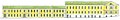
 Западная сторона Хитровской площади.jpg 800 × 146; 59 KB
-
 Картинная галерея В.А. Кокорева. 1864. А. Гребнев.jpg 792 × 586; 250 KB
-
 Левитан и Кувшинникова.jpg 1,680 × 2,293; 1.18 MB
-
 Молодой И. Эренбург.jpg 433 × 636; 86 KB
-
 Пер.Подколокольный,11, 15.04.2012 - panoramio.jpg 1,200 × 800; 254 KB
-
 План владения С. Г. Калустовой (б. Остермана). 1816.jpg 3,803 × 3,036; 3 MB
-
 План Горихвостова. 1768.jpg 778 × 623; 482 KB
-
 Постройка Хитрово104.jpg 1,381 × 1,152; 372 KB
-
 Предположительный скульптурный портрет Н.З. Хитрово.JPG 882 × 950; 356 KB
-
 Распоряжение Лужкова о воссоздании Хитровской площади.jpg 868 × 1,132; 166 KB
-
 Реконструкция Хитровской площади - строительство сквера.jpg 3,264 × 2,448; 2.89 MB
-
 Ресторан "Экспедиция" на Хитровке.JPG 2,851 × 2,056; 1.15 MB
-
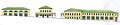
 Северная сторона Хитровской площади.jpg 773 × 126; 48 KB
-
 Стольник и воевода Емельян Бутурлин. Н.Аввакумов.jpg 277 × 320; 33 KB
-
 Торговые ряды , построенные Н.З.Хитрово на площади..jpg 800 × 168; 39 KB
-
 Торговые ряды Хитрово.11.06.2008.jpg 1,376 × 1,065; 278 KB
-
 Фёдор Тютчев.jpg 384 × 512; 90 KB
-
 Хитровская площадь и Петропавловский переулок.jpg 3,072 × 2,304; 4.94 MB
-

-

-
 Хитровская площадь, Торговые ряды Хитрово.jpg 3,072 × 2,304; 4.64 MB
-
 Хитровская площадь.25.01.10 v2.jpg 2,400 × 1,520; 2.61 MB
-
 Хитровская площадь.25.01.10.jpg 4,354 × 2,757; 5.39 MB
-
 Хитровский субботник.jpg 800 × 533; 164 KB


.jpg)
.jpg)


.jpg)


._1816.jpg)


_-_panoramio_(1).jpg)
_-_panoramio.jpg)

