Category:Loch Morar
Jump to navigation
Jump to search

See Loch Morar.
freshwater loch in Lochaber, Highland, Scotland, UK, outflows at its west to the River Morar  | |||||
| Upload media | |||||
| Instance of | |||||
|---|---|---|---|---|---|
| Location | Highland, Scottish Highlands, Scotland | ||||
| Heritage designation | |||||
| Length |
| ||||
| Area |
| ||||
| Elevation above sea level |
| ||||
| Inflows |
| ||||
| Outflows |
| ||||
| Basin country | |||||
 | |||||
Subcategories
This category has the following 5 subcategories, out of 5 total.
B
- Brinacory Island (3 F)
C
- Allt Cam Carach (3 F)
E
- Eilean Bàn, Loch Morar (5 F)
- Eilean Ghibbi (2 F)
R
- River Meoble (2 F)
Media in category "Loch Morar"
The following 130 files are in this category, out of 130 total.
-
 19960531 06 Morar Viaduct (5454829694).jpg 1,800 × 1,143; 1.4 MB
-
 A special place (Loch Morar) - geograph.org.uk - 89894.jpg 640 × 480; 111 KB
-
 Above Loch Morar - geograph.org.uk - 714425.jpg 640 × 480; 86 KB
-
 An Romasaig - geograph.org.uk - 2400390.jpg 640 × 480; 76 KB
-
 Beside Loch Morar - geograph.org.uk - 999143.jpg 640 × 426; 65 KB
-
 Boats beside Loch Morar - geograph.org.uk - 3960237.jpg 640 × 427; 381 KB
-
 Boats by Loch Morar - geograph.org.uk - 3905815.jpg 1,280 × 851; 450 KB
-
 Boats on an inlet on Loch Morar - geograph.org.uk - 4964533.jpg 1,800 × 1,012; 1.5 MB
-
 Boats on Loch Morar - geograph.org.uk - 5836316.jpg 1,024 × 682; 918 KB
-
 Boats on Loch Morar - geograph.org.uk - 726756.jpg 640 × 480; 47 KB
-
 Bracara by Loch Morar - geograph.org.uk - 1802294.jpg 640 × 459; 123 KB
-
 Bracara Loch Morar geograph-3378770-by-Ben-Brooksbank.jpg 920 × 540; 468 KB
-
 Bun an Loin, Loch Morar - geograph.org.uk - 869298.jpg 427 × 640; 91 KB
-
 Bun an Lòin, Loch Morar - geograph.org.uk - 4711716.jpg 1,024 × 694; 194 KB
-
 Camas na Togalach, Loch Morar - geograph.org.uk - 720343.jpg 1,000 × 667; 200 KB
-
 Camus Ruadh, Loch Morar - geograph.org.uk - 188974.jpg 640 × 480; 147 KB
-
 Camus Ruadh, Loch Morar - geograph.org.uk - 188978.jpg 640 × 480; 137 KB
-
 Canoeists, Loch Morar - geograph.org.uk - 1203384.jpg 640 × 426; 57 KB
-
 Ceann an t-Saideil, Loch Morar - geograph.org.uk - 896040.jpg 640 × 480; 64 KB
-
 Ceann Loch Morar. - geograph.org.uk - 47594.jpg 640 × 412; 59 KB
-
 Cottage-Craft Shop, Bracara, Loch Morar - geograph.org.uk - 89492.jpg 640 × 480; 131 KB
-
 Exit of Loch Morar - geograph.org.uk - 4964541.jpg 1,800 × 1,012; 1.26 MB
-
 First glimpse of Loch Morar - geograph.org.uk - 1081500.jpg 640 × 415; 44 KB
-

-
 Good path building by Loch Morar - geograph.org.uk - 2072998.jpg 640 × 480; 86 KB
-
 Head of Loch Morar - geograph.org.uk - 20009.jpg 640 × 409; 56 KB
-
 Hills And Islands Of Loch Morar. - geograph.org.uk - 772790.jpg 640 × 480; 52 KB
-
 House at Bracora, Loch Morar - geograph.org.uk - 5613828.jpg 5,184 × 2,920; 5.33 MB
-
 Ile Coire and Loch Morar - geograph.org.uk - 471417.jpg 640 × 480; 87 KB
-
 Inbhir Beag pier, Loch Morar - geograph.org.uk - 4710909.jpg 1,024 × 681; 151 KB
-
 Island on Loch Morar - geograph.org.uk - 35153.jpg 640 × 395; 92 KB
-

-
 Jetty at Loch Morar - geograph.org.uk - 3925443.jpg 1,600 × 1,200; 237 KB
-
 Jetty at Loch Morar - geograph.org.uk - 4236981.jpg 640 × 427; 73 KB
-
 Jetty on Loch Morar - geograph.org.uk - 215303.jpg 640 × 480; 301 KB
-
 Jetty on Loch Morar - geograph.org.uk - 2158356.jpg 800 × 531; 101 KB
-
 Jetty on Loch Morar - geograph.org.uk - 2158363.jpg 800 × 531; 119 KB
-
 Jetty on Loch Morar - geograph.org.uk - 511532.jpg 640 × 427; 70 KB
-
 Loch Morar - geograph.org.uk - 1117928.jpg 640 × 480; 67 KB
-
 Loch Morar - geograph.org.uk - 1178258.jpg 640 × 480; 84 KB
-
 Loch Morar - geograph.org.uk - 1178596.jpg 640 × 480; 100 KB
-
 Loch Morar - geograph.org.uk - 17380.jpg 640 × 480; 91 KB
-
 Loch Morar - geograph.org.uk - 294494.jpg 640 × 427; 58 KB
-
 Loch Morar - geograph.org.uk - 3905820.jpg 1,280 × 851; 327 KB
-
 Loch Morar - geograph.org.uk - 3905859.jpg 1,280 × 851; 347 KB
-
 Loch Morar - geograph.org.uk - 3905862.jpg 1,280 × 851; 319 KB
-
 Loch Morar - geograph.org.uk - 5111699.jpg 3,444 × 2,162; 3.09 MB
-
 Loch Morar - geograph.org.uk - 5736949.jpg 640 × 480; 89 KB
-
 Loch Morar - geograph.org.uk - 5836291.jpg 1,024 × 678; 997 KB
-
 Loch Morar - geograph.org.uk - 6107613.jpg 800 × 516; 110 KB
-
 Loch Morar - geograph.org.uk - 999097.jpg 640 × 426; 73 KB
-
 Loch Morar - geograph.org.uk - 999113.jpg 640 × 426; 62 KB
-
 Loch Morar - Roinn a'Ghiubhais - geograph.org.uk - 189305.jpg 640 × 480; 119 KB
-

-

-
 Loch Morar and Brinacory Island - geograph.org.uk - 3921496.jpg 1,600 × 421; 155 KB
-
 Loch Morar and jetty - geograph.org.uk - 3491545.jpg 1,600 × 991; 260 KB
-
 Loch Morar and the Sound of Arisaig, Scotland, 2 Oct. 2011 - Flickr - PhillipC.jpg 4,288 × 2,848; 2.22 MB
-
 Loch Morar beach at Bracorina - geograph.org.uk - 4710887.jpg 800 × 530; 101 KB
-
 Loch Morar from St Cumin's church - geograph.org.uk - 1802262.jpg 640 × 427; 71 KB
-

-
 Loch Morar from the Cross - panoramio.jpg 3,008 × 2,000; 768 KB
-
 Loch Morar From the South - geograph.org.uk - 772830.jpg 480 × 640; 91 KB
-
 Loch Morar hydro station - geograph.org.uk - 909935.jpg 640 × 480; 92 KB
-
 Loch Morar islands - geograph.org.uk - 1125181.jpg 640 × 477; 37 KB
-
-
 Loch Morar path - geograph.org.uk - 1159720.jpg 640 × 480; 91 KB
-
 Loch Morar south shore at Camus Luinge - geograph.org.uk - 35036.jpg 640 × 403; 87 KB
-
 Loch Morar towards Rhubana - geograph.org.uk - 2943786.jpg 640 × 480; 68 KB
-
 Loch Morar, Bracorina - geograph.org.uk - 742251.jpg 640 × 480; 72 KB
-
 Loch Morar, Bracorina - geograph.org.uk - 742269.jpg 640 × 480; 46 KB
-
 Loch Morar, headland below Sron Mhor - geograph.org.uk - 1364308.jpg 640 × 480; 62 KB
-
 Loch Morar, Inbhir Beag - geograph.org.uk - 742443.jpg 640 × 480; 72 KB
-
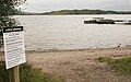
 Loch Morar, instructions to users - geograph.org.uk - 3905826.jpg 1,280 × 851; 347 KB
-
 Loch Morar, South East corner - geograph.org.uk - 2400400.jpg 3,264 × 2,448; 2.68 MB
-
 Loch Morar, south shore - geograph.org.uk - 2400520.jpg 3,264 × 2,448; 2.69 MB
-
 Loch Morar.jpg 602 × 346; 44 KB
-
 LochMorar.JPG 1,280 × 960; 221 KB
-
 Looking east along Loch Morar - geograph.org.uk - 3638525.jpg 1,572 × 1,020; 1.03 MB
-
 Looking over Loch Morar, Tarbet and Loch Nevis to Skye - geograph.org.uk - 2400465.jpg 3,264 × 2,448; 2.52 MB
-

-
 Looking west along Loch Morar - geograph.org.uk - 2265575.jpg 3,264 × 2,448; 2.78 MB
-
 Luinga Mhor Looking Towards Morar - panoramio.jpg 2,128 × 1,269; 1.78 MB
-
 Meall nan Each at head of Loch Morar - geograph.org.uk - 896226.jpg 640 × 480; 71 KB
-
 Moody Loch Morar - geograph.org.uk - 2072908.jpg 640 × 480; 37 KB
-
 New Boathouse - geograph.org.uk - 773771.jpg 640 × 480; 89 KB
-
 New jetty, Morar - geograph.org.uk - 920309.jpg 640 × 480; 59 KB
-
 North Loch Morar - geograph.org.uk - 2418235.jpg 1,600 × 1,074; 723 KB
-
 North Morar - geograph.org.uk - 743575.jpg 640 × 480; 65 KB
-
 Novel use for a kayak - geograph.org.uk - 773852.jpg 640 × 480; 112 KB
-
 Ordnance Survey One-Inch Sheet 46 Ardnamurchan & Loch Shiel, Published 1947.jpg 12,151 × 10,073; 11.8 MB
-
 Our Lady of Perpetual Succour & St Cumin, Morar.jpg 4,470 × 3,029; 6.47 MB
-
 Pier, Loch Morar - geograph.org.uk - 189638.jpg 640 × 480; 100 KB
-
 Rocks in Loch Morar - geograph.org.uk - 920315.jpg 640 × 480; 54 KB
-
 Ruined farmstead by Loch Morar - geograph.org.uk - 1203372.jpg 640 × 426; 69 KB
-
 Sandy beaches on Loch Morar - geograph.org.uk - 896223.jpg 480 × 640; 59 KB
-
 Sheep Fank and Shed - geograph.org.uk - 2418259.jpg 1,600 × 1,074; 659 KB
-
 Small stone bridge on the Loch Morar path - geograph.org.uk - 524291.jpg 640 × 480; 128 KB
-

-

-
 Sron Ghaothar on Loch Morar - geograph.org.uk - 190066.jpg 640 × 480; 75 KB
-
 Standing on the bridge over Loch Morar.jpg 3,456 × 2,304; 2.03 MB
-
 Steep shingle beach - geograph.org.uk - 941640.jpg 640 × 480; 141 KB
-
 Stoul path, Bracorina - geograph.org.uk - 742262.jpg 640 × 480; 75 KB
-
 Swordland Sheepfold Hut - geograph.org.uk - 130677.jpg 640 × 451; 92 KB
-
 The Bracara road - geograph.org.uk - 773761.jpg 640 × 480; 78 KB
-
 The Loch Morar Corniche - geograph.org.uk - 524278.jpg 480 × 640; 84 KB
-
 The western ridge - geograph.org.uk - 484161.jpg 640 × 427; 296 KB
-
 Towards Loch Morar - geograph.org.uk - 772776.jpg 640 × 480; 65 KB
-
 Track beside Loch Morar - geograph.org.uk - 742440.jpg 640 × 480; 75 KB
-

-
 View from Druim a' Chuirn ridge - geograph.org.uk - 855761.jpg 640 × 480; 71 KB
-

-
 View of Loch Morar - geograph.org.uk - 1395517.jpg 640 × 427; 69 KB
-

-
 View towards Rubha Garbh, Loch Morar - geograph.org.uk - 772784.jpg 640 × 480; 68 KB
-
 Waterfall above Loch Morar - geograph.org.uk - 565613.jpg 427 × 640; 362 KB
-
 Woodland above Loch Morar - geograph.org.uk - 920321.jpg 640 × 480; 64 KB
-
 Woods by Loch Morar - geograph.org.uk - 920310.jpg 640 × 480; 129 KB
-
 Boulders in Loch Morar - geograph.org.uk - 524287.jpg 640 × 480; 91 KB
-
 Bracorina, Loch Morar - geograph.org.uk - 581846.jpg 640 × 406; 53 KB
-
 Loch Morar - a lasting memory - geograph.org.uk - 194954.jpg 640 × 480; 78 KB
-
 Loch Morar - geograph.org.uk - 188912.jpg 640 × 480; 107 KB
-
 Loch Morar - geograph.org.uk - 188957.jpg 640 × 480; 86 KB
-
 Loch Morar - geograph.org.uk - 189637.jpg 640 × 480; 97 KB
-
 Loch Morar - geograph.org.uk - 511518.jpg 640 × 427; 84 KB
-
 Loch Morar - geograph.org.uk - 89953.jpg 640 × 480; 95 KB
-
 Loch Morar from Rubha Dubh - geograph.org.uk - 89883.jpg 640 × 480; 102 KB
-
 Loch Morar islands - geograph.org.uk - 34972.jpg 640 × 480; 82 KB
-
 Loch Morar, pebble beach - geograph.org.uk - 17528.jpg 640 × 480; 101 KB
.jpg)
_-_geograph.org.uk_-_89894.jpg)


_-_geograph.org.uk_-_1395526.jpg)


