Category:Mousa Broch
Jump to navigation
Jump to search
| Object location | | View all coordinates using: OpenStreetMap |
|---|
|
This is a category about scheduled monument number 90223
|
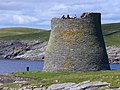
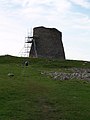
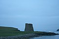
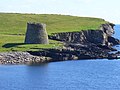
tallest preserved example of an Iron Age broch or round tower  | |||||
| Upload media | |||||
| Instance of | |||||
|---|---|---|---|---|---|
| Location |
| ||||
| Heritage designation |
| ||||
 | |||||
Media in category "Mousa Broch"
The following 98 files are in this category, out of 98 total.
-
 A misty day at Mousa Broch.jpg 640 × 480; 89 KB
-
 Atop Mousa broch.jpg 2,048 × 1,536; 1.44 MB
-
 Broch from the sea.jpg 1,280 × 960; 288 KB
-
 Broch of Mousa (1).jpg 3,456 × 2,304; 523 KB
-
 Broch of Mousa (2).jpg 960 × 1,280; 910 KB
-
 Broch of Mousa (3).jpg 1,280 × 960; 544 KB
-
 Broch of Mousa (4).jpg 960 × 1,280; 654 KB
-
 Broch of Mousa (5).jpg 1,280 × 960; 382 KB
-
 Broch of Mousa (6).jpg 1,280 × 960; 468 KB
-
 Broch of Mousa (7).jpg 960 × 1,280; 497 KB
-
 Broch of Mousa (8).jpg 1,280 × 960; 633 KB
-
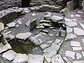 Broch of Mousa - Central floor - geograph.org.uk - 2706514.jpg 1,333 × 1,000; 1.21 MB
-
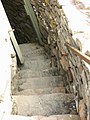
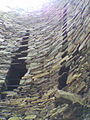
 Broch of Mousa - Climbing the stone staircase - geograph.org.uk - 2706519.jpg 1,000 × 1,333; 1.1 MB
-
 Broch of Mousa - geograph.org.uk - 2079773.jpg 2,560 × 1,920; 1.75 MB
-
 Broch of Mousa - geograph.org.uk - 2739.jpg 479 × 640; 33 KB
-
 Broch of Mousa - geograph.org.uk - 2800.jpg 347 × 528; 107 KB
-
 Broch of Mousa - geograph.org.uk - 5929477.jpg 800 × 600; 595 KB
-
 Broch of Mousa - interior - geograph.org.uk - 970888.jpg 480 × 640; 83 KB
-
 Broch of Mousa - interior - geograph.org.uk - 970890.jpg 640 × 480; 112 KB
-
 Broch of Mousa - interior - geograph.org.uk - 970891.jpg 480 × 640; 121 KB
-
 Broch of Mousa - interior steps - geograph.org.uk - 970892.jpg 480 × 640; 71 KB
-
 Broch of Mousa - Looking down through internal window - geograph.org.uk - 2706532.jpg 1,000 × 1,333; 1.38 MB
-
 Broch of Mousa - Looking upwards inside - geograph.org.uk - 2706524.jpg 1,000 × 1,333; 1.36 MB
-
 Broch of Mousa - The view from the top - geograph.org.uk - 2706550.jpg 1,000 × 1,054; 912 KB
-
 Broch of Mousa - View down the stone staircase - geograph.org.uk - 2706536.jpg 1,000 × 1,333; 1.04 MB
-
 Broch of Mousa - View straight down inside from the top - geograph.org.uk - 2706541.jpg 1,122 × 1,000; 1.09 MB
-
 Broch of Mousa from Burgi Ayre - geograph.org.uk - 2706346.jpg 1,333 × 1,000; 1.17 MB
-
 Broch of Mousa from the air (geograph 7285713).jpg 1,600 × 1,071; 497 KB
-
 Broch of Mousa from the east - geograph.org.uk - 2706417.jpg 1,000 × 1,333; 1.05 MB
-
 Broch of Mousa from the Sea.jpg 6,000 × 4,000; 12.16 MB
-
 Broch of Mousa, Shetland - geograph.org.uk - 5512004.jpg 800 × 573; 130 KB
-
 Broch of Mousa, Shetland - geograph.org.uk - 5512028.jpg 800 × 548; 162 KB
-
 Hebridean Sky IMG 2503 (28407648396).jpg 4,218 × 2,275; 3.13 MB
-
 Hebridean Sky IMG 2510 (28335310602).jpg 3,722 × 2,011; 2.76 MB
-
 Inside Mousa 2.jpg 1,536 × 2,048; 1.37 MB
-
 Inside Mousa Broch - geograph.org.uk - 2079876.jpg 1,920 × 2,560; 1.75 MB
-
 Inside Mousa.jpg 3,024 × 4,032; 4.55 MB
-
 Inside the Broch of Mousa - geograph.org.uk - 2706508.jpg 1,333 × 1,000; 1.27 MB
-
 Inside the Mousa Broch.jpg 3,456 × 2,304; 575 KB
-
 Interior of Mousa Broch - geograph.org.uk - 6180027.jpg 1,200 × 1,800; 564 KB
-
 Interior of the Broch at Mousa - geograph.org.uk - 724549.jpg 480 × 640; 138 KB
-
 Interior of the broch on Mousa Island - geograph.org.uk - 66742.jpg 480 × 640; 26 KB
-
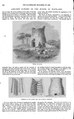 Ancient Towers in the North of Scotland (IA jstor-20538141).pdf 1,002 × 1,614; 633 KB
-
 Lochan, Mousa - geograph.org.uk - 796259.jpg 640 × 322; 79 KB
-
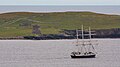 Lord Nelson IMG 2891 (20576031425).jpg 4,090 × 2,275; 3.1 MB
-
 Mousa 02.jpg 4,080 × 3,072; 3.77 MB
-
 Mousa 04.jpg 3,067 × 2,249; 1.8 MB
-
 Mousa 05.jpg 3,072 × 4,080; 3.89 MB
-
 Mousa Broch - geograph.org.uk - 335305.jpg 640 × 440; 65 KB
-
 Mousa broch - geograph.org.uk - 346708.jpg 424 × 640; 63 KB
-
 Mousa Broch - geograph.org.uk - 3586538.jpg 640 × 480; 287 KB
-
 Mousa Broch - geograph.org.uk - 51353.jpg 640 × 286; 65 KB
-
 Mousa Broch - geograph.org.uk - 6179907.jpg 1,600 × 1,097; 223 KB
-
 Mousa Broch - geograph.org.uk - 629841.jpg 640 × 450; 247 KB
-
 Mousa Broch - Information board - geograph.org.uk - 970896.jpg 640 × 480; 79 KB
-
 Mousa Broch 20080821 01.jpg 800 × 501; 173 KB
-
 Mousa Broch 20080821 02.jpg 800 × 591; 234 KB
-
 Mousa Broch 20080821 03.jpg 800 × 530; 262 KB
-
 Mousa Broch 20080821 04.jpg 367 × 700; 189 KB
-
 Mousa Broch and coastline - geograph.org.uk - 960459.jpg 640 × 480; 85 KB
-
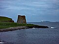
 Mousa Broch at 1am in the morning - geograph.org.uk - 459928.jpg 640 × 427; 30 KB
-
 Mousa Broch Floor - geograph.org.uk - 2080972.jpg 2,560 × 1,920; 2.34 MB
-
 Mousa Broch from the ferry - geograph.org.uk - 2704970.jpg 1,333 × 1,000; 989 KB
-
 Mousa Broch from the North - geograph.org.uk - 2081000.jpg 2,560 × 1,920; 1.83 MB
-
 Mousa broch.jpg 2,048 × 1,536; 1.29 MB
-
 Mousa from the sea.jpg 4,032 × 3,024; 2.38 MB
-
 Mousa, boardwalk to the broch - geograph.org.uk - 3831521.jpg 480 × 640; 70 KB
-
-
 Mousa, descending the broch steps - geograph.org.uk - 3831568.jpg 480 × 640; 97 KB
-
 Mousa, inside the broch - geograph.org.uk - 3831547.jpg 480 × 640; 128 KB
-
 Mousa, looking down inside the broch - geograph.org.uk - 3831554.jpg 640 × 480; 114 KB
-

-
 Mousa, steps inside the broch - geograph.org.uk - 3831549.jpg 480 × 640; 84 KB
-
 Mousa, the broch - geograph.org.uk - 3831543.jpg 640 × 480; 72 KB
-
-
 Mousabroch.jpg 1,235 × 816; 249 KB
-
 Off the east side of Shetland's south mainland showing the famous Mousa Broch.jpg 4,270 × 2,141; 2.87 MB
-
 Peerie Bard, Mousa - geograph.org.uk - 4541934.jpg 1,024 × 681; 80 KB
-
 Pictishtowerofmousa.png 625 × 559; 806 KB
-
 Piktisk festning mousa.png 738 × 819; 516 KB
-
 Point at Mousa Broch - geograph.org.uk - 2079778.jpg 2,560 × 1,920; 1.75 MB
-
 Polar Pioneer IMG 3621 (34611702393).jpg 4,262 × 2,379; 2.75 MB
-
 Polar Pioneer IMG 4943 (9176216391).jpg 4,272 × 2,241; 2.7 MB
-
 Polar Pioneer IMG 4946 (9176228861).jpg 4,188 × 2,401; 4.09 MB
-
 Polar Pioneer IMG 4947 (9178455352).jpg 4,100 × 2,277; 3.35 MB
-
 Polar Pioneer IMG 4956 (9178463074).jpg 3,521 × 2,156; 2.66 MB
-
 Polar Pioneer IMG 4959 (9176209197).jpg 3,775 × 2,227; 3.16 MB
-
 Shetland1.png 1,325 × 787; 404 KB
-
 St Clair IV (11816235103).jpg 3,446 × 2,150; 3.09 MB
-
 Stairs up between the walls of Mousa Broch - geograph.org.uk - 6180031.jpg 1,200 × 1,800; 354 KB
-
 Sunlight and sea reflected inside Mousa.jpg 3,024 × 4,032; 3.17 MB
-
 The Broch at Mousa - geograph.org.uk - 724543.jpg 480 × 640; 62 KB
-
 The Broch at Mousa from the ferry - geograph.org.uk - 1574780.jpg 640 × 480; 62 KB
-
 The Broch of Mousa - 548754520.jpg 1,944 × 2,592; 2.03 MB
-
 The Broch of Mousa - 548816051.jpg 2,592 × 1,944; 2.09 MB
-
 The Broch of Mousa.jpg 2,592 × 1,944; 1.99 MB
-
 The brough of Mousa, Shetland, Schotland, RP-F-00-6100(V).jpg 3,892 × 2,982; 1.15 MB
-
 View from top of Mousa Broch - geograph.org.uk - 6180039.jpg 1,600 × 1,000; 236 KB


.jpg)
.jpg)
.jpg)
.jpg)
.jpg)
.jpg)
.jpg)
.jpg)


.jpg)


.jpg)
.jpg)


.jpg)


.jpg)
.jpg)
.jpg)
.jpg)
.jpg)
.jpg)

.jpg)


.jpg)
