Category:Palar River
Jump to navigation
Jump to search
river in India   | |||||
| Upload media | |||||
| Instance of | |||||
|---|---|---|---|---|---|
| Location | |||||
| Length |
| ||||
| Mouth of the watercourse | |||||
| Tributary |
| ||||
 | |||||
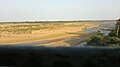
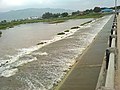
Palar (Kannada: ಪಾಲಾರ್ ನದಿ; Tamil: பாலாறு) is a river of southern India. It rises in Nandi Hills in Kolar district of Karnataka state, and flows 93 km in Karnataka, 33 km in Andhra Pradesh and 222 km in Tamil Nadu before its confluence into the Bay of Bengal at Vayalur about 100 km south of Chennai. It flows as a Guptagamini (underground course) for a long distance only to emerge near Bethamangala town, from where, gathering water and speed, it flows eastward down the Deccan Plateau.
Media in category "Palar River"
The following 10 files are in this category, out of 10 total.
-
 138950.jpg 912 × 506; 46 KB
-
 Mouth of the Palar.jpg 1,578 × 1,126; 208 KB
-
 Palar river, vellore.jpg 4,208 × 3,120; 3.06 MB
-
 Palar river.jpg 3,264 × 1,832; 772 KB
-
 Palar Vellore 1975.jpg 710 × 358; 92 KB
-
 Palar VNB.jpg 400 × 300; 36 KB
-
 Source of Palar.jpg 2,592 × 1,944; 1.98 MB
-
 The Palar Challenge.jpg 500 × 375; 52 KB
-
 The Palar river.JPG 3,648 × 2,736; 2.68 MB
-
 பாலாறு இடம்;செய்யாறு.JPG 1,920 × 1,080; 574 KB


