Category:Uinta Mountains
Jump to navigation
Jump to search
mountain range in northeastern Utah and northwestern Colorado in the United States  Vista del pico Kings | |||||
| Upload media | |||||
| Instance of | |||||
|---|---|---|---|---|---|
| Made from material | |||||
| Location |
| ||||
| Mountain range | |||||
| Highest point | |||||
| Elevation above sea level |
| ||||
 | |||||
English: Media related to the {{w:Uinta Mountains}}, a mountain range in northeastern Utah and northwestern Colorado in the United States.
- An east-west trending mountain range of the Rocky Mountains System, in the Uintah Basin physiographic Section, of the larger Colorado Plateau physiographic Province]]
- See also wikipedia (english text): Category: Features of the Uinta Mountains.
Subcategories
This category has the following 29 subcategories, out of 29 total.
A
- Mount Agassiz (Utah) (12 F)
B
- Bald Mountain (Uinta Range) (2 F)
- Bald Mountain Pass (2 F)
- Browne Lake (Utah) (1 F)
D
G
- Gilbert Peak (Utah) (3 F)
H
- Hayden Peak (Utah) (5 F)
K
- Kings Peak (Utah) (15 F)
L
M
N
P
- Provo River Falls (5 F)
R
S
- South Kings Peak (Utah) (2 F)
T
U
- Uinta Highline Trail (12 F)
W
Media in category "Uinta Mountains"
The following 96 files are in this category, out of 96 total.
-
 2015.06.27 13.08.53 DSCN2532 - Flickr - andrey zharkikh.jpg 3,648 × 2,736; 2.53 MB
-
 2015.07.11 10.27.45 DSCN2592 - Flickr - andrey zharkikh.jpg 3,648 × 2,736; 1.61 MB
-
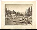
 A saw mill in the Uinta Mountains, Summit County, Utah - NARA - 516920.jpg 3,000 × 2,121; 1.59 MB
-
 A storm over Allsop Lake.jpg 1,885 × 984; 543 KB
-
 Bald Mountain - Uintahs (CCBYSA).jpg 2,048 × 1,152; 282 KB
-
 BearRiverUT.jpg 600 × 505; 103 KB
-
 Bird Call Lake - panoramio.jpg 2,816 × 2,112; 2.42 MB
-
 Bozeman01.png 1,049 × 1,033; 1.76 MB
-
-
-
 Camp Steiner Docks at Scout Lake, Uinta Mountains, Utah.JPG 1,600 × 1,200; 230 KB
-
 Carter's Lake, Uinta Mountains. Summit County, Utah - NARA - 516931.jpg 3,000 × 2,206; 1.51 MB
-
 Chepeta Lake, Uinta, Utah; elevation 3230 m (10,600 ft). - andrey zharkikh.jpg 3,648 × 2,736; 1.03 MB
-
 Cliff Lake in the High Uintas.jpg 3,840 × 2,160; 2.74 MB
-
 Dead Horse Peak, east.jpg 2,048 × 1,536; 1.78 MB
-
 Dead Horse Peak, northeast.jpg 1,842 × 1,404; 961 KB
-
 Deer at Forest Lake - panoramio.jpg 4,288 × 3,216; 7.14 MB
-
 Duchesne County, UT, USA - panoramio (2).jpg 4,320 × 3,240; 3.47 MB
-
 Duchesne County, UT, USA - panoramio (3).jpg 4,320 × 3,240; 3.12 MB
-
 Duchesne County, UT, USA - panoramio (4).jpg 4,320 × 3,240; 3.02 MB
-
 El Capitan, in miniature. Uinta Mountains. Summit County, Utah. - NARA - 516933.jpg 2,276 × 3,000; 1.9 MB
-
 Explorer Peak aerial.jpg 2,228 × 1,439; 998 KB
-
 Explorer Peak.jpg 1,364 × 918; 440 KB
-
 Foothills of the Uintas South of Evanston, Wyoming.jpg 4,000 × 3,000; 7.07 MB
-
 Forest in Uinta Mountains (Unsplash).jpg 4,928 × 3,264; 13.9 MB
-
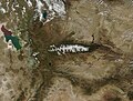 Fresh Snow in the Uinta Mountains (MODIS).jpg 2,212 × 1,683; 649 KB
-
 HD.11C.098 (14740079677).jpg 3,200 × 2,532; 1.36 MB
-
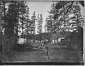
 Head of Black's Fork, Uinta Mountains. Summit County, Utah - NARA - 516926.jpg 3,000 × 2,223; 1.67 MB
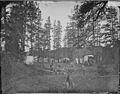
-
 Head of Black's Fork, Uinta Mountains. Summit County, Utah - NARA - 516927.jpg 3,000 × 2,226; 1.18 MB
-
 Henrys Fork Peak.jpg 3,168 × 2,152; 1.38 MB
-
 High Rockies SRTM30.JPG 500 × 607; 64 KB
-
 High Uintas Near Utah-Wyoming Border.jpg 4,000 × 2,840; 5.41 MB
-
 High Uintas Peaks.jpg 1,761 × 1,315; 536 KB
-
 High Uintas viewed from Anderson Pass.jpg 2,592 × 1,944; 2.6 MB
-
 High Uintas viewed from east side of Anderson Pass.jpg 2,592 × 1,944; 3.18 MB
-
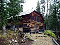 John Grix Cabin.JPG 4,276 × 3,200; 2.94 MB
-
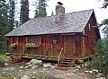 John Maycock Cabin.JPG 4,188 × 3,078; 2.6 MB
-
 July Snow in the Uinta Mountains.jpg 4,413 × 3,096; 7.01 MB
-
 Kings Peak with Henry's Fork Basin.jpg 2,560 × 1,920; 1.03 MB
-
 Kletting Peak, A-1 Peak.jpg 4,096 × 1,365; 1.88 MB
-
 Kweeyahgut Peak.jpg 2,811 × 1,855; 1.36 MB
-
 Lake Jan, Uinta Mountains, Utah - NARA - 519660.jpg 3,000 × 1,914; 1.51 MB
-
 Lake Jan, Uinta Mountains, Utah - NARA - 519661.jpg 3,000 × 1,881; 1.67 MB
-
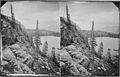
 Lake Jan, Uinta Mts, (Utah) - T. H. O'Sullivan, phot. LCCN2004667731.tif 8,825 × 6,882; 173.79 MB
-
 Lake Lal, Uinta Mountains, Utah - NARA - 519651.jpg 3,000 × 1,901; 1,011 KB
-
 Lake Lal, Uinta Mountains, Utah - NARA - 519653.jpg 3,000 × 1,927; 1.53 MB
-
 Lake Lal, Uinta Mountains, Utah - NARA - 519654.jpg 3,000 × 1,896; 1.42 MB
-
 Lake Lal, Uinta Mountains, Utah - NARA - 519655.jpg 3,000 × 1,890; 1.41 MB
-
 Lake Lal, Uinta Mountains, Utah - NARA - 519656.jpg 3,000 × 1,858; 935 KB
-
 Lake Lal, Uinta Mountains, Utah - NARA - 519657.jpg 3,000 × 1,917; 1.52 MB
-
 Lake Lal. Summit of Uinta Mountains, Utah - NARA - 519522.jpg 3,000 × 2,274; 1.54 MB
-
 Lamotte, Ostler, Spread Eagle peaks.jpg 2,462 × 1,681; 1.38 MB
-
 Mount Beulah - Autumn.jpg 1,120 × 792; 334 KB
-
 Mount Lovenia, High Uintas Wilderness.jpg 1,973 × 1,370; 549 KB
-
 Mount Powell (Utah).jpg 2,243 × 1,401; 958 KB
-
 Nahcolite deposition model.png 985 × 534; 87 KB
-
 Near Lake Lal, Uinta Mountains, Utah - NARA - 519652.jpg 3,000 × 1,881; 1.49 MB
-
 Near Lakes Lal and Jan, Uinta Mountains, Utah - NARA - 519658.jpg 3,000 × 1,889; 1.41 MB
-
 Nutters Ridge - Social 1.jpg 2,048 × 1,154; 208 KB
-
 Ostler Peak aerial.jpg 3,405 × 2,226; 1.7 MB
-
 Ostler Peak in autumn.jpg 1,901 × 1,359; 1,010 KB
-
 Ostler Peak, Christmas Meadows.jpg 3,006 × 2,190; 1.84 MB
-
 Ostler Peak, Utah.jpg 1,614 × 1,294; 686 KB
-
 Ostler Peak.jpg 3,688 × 2,216; 1.56 MB
-
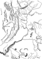
 PSM V07 D402 Uinta mountains sectional image.jpg 2,512 × 1,131; 568 KB
-
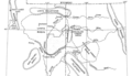
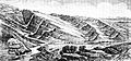 PSM V07 D405 Northern slope of the uinta mountains.jpg 2,356 × 1,099; 801 KB
-
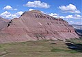
 Red Castle in the Uinta Mountains.jpg 4,032 × 3,024; 2.59 MB
-
 Storm over the Cathedral.jpg 1,802 × 1,042; 555 KB
-
 Sunrise in Ottoson Basin.jpg 1,600 × 1,200; 674 KB
-
 The Cathedral, Allsop Lake.jpg 1,459 × 968; 456 KB
-
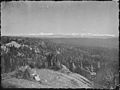
 The Uinta Mountains, view from Photograph Ridge. Summit County, Utah. - NARA - 516923.jpg 3,000 × 2,248; 1.31 MB
-

-
-

-
 Timpanogos Valley BHoU-p13.png 2,870 × 4,082; 225 KB
-
 Triassic-Jurassic Uinta Mtns.jpg 3,977 × 6,747; 12.85 MB
-
 Uinta Mountains, head of Black's Fork. Summit County, Utah - NARA - 517407.jpg 2,448 × 3,000; 1.37 MB
-
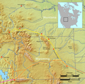
 Uinta Basin map.png 976 × 561; 77 KB
-
 Uinta Mountains northeast Utah Topo Rainbow Zebra 1938.png 5,867 × 3,599; 23.89 MB
-
 Uinta Mountains, head of Blacks Fork. Summit County, Utah. 1870.jpg 6,720 × 3,738; 2.53 MB
-
 Uinta Mountains.jpg 1,024 × 768; 215 KB
-
 Uinta mountains.jpg 3,264 × 2,448; 2.94 MB
-
 Uinta Mtn Monocline.jpg 13,742 × 4,080; 43.56 MB
-
 Uintas 1.jpg 960 × 720; 159 KB
-
 Uintas 1.JPG 2,048 × 1,536; 757 KB
-
 Uintas 2.jpg 960 × 720; 164 KB
-
 Uintas 3.jpg 960 × 720; 166 KB
-
 Uintas 4.jpg 960 × 720; 174 KB
-
 Uintas 5.jpg 960 × 720; 123 KB
-
 Unidentified, Uinta Mountains ^ Utah - NARA - 519662.jpg 3,000 × 1,898; 2.03 MB
-
-
 Wasatch Peak, High Uintas Wilderness.jpg 2,048 × 1,536; 1.74 MB
-
 WCNF Wilderness Map.jpg 700 × 513; 91 KB
-
 Yard Peak aerial.jpg 3,504 × 1,399; 3.68 MB
-
 Yard Peak.jpg 1,414 × 1,128; 643 KB
-
 Leatherside Chub.jpg 3,572 × 1,848; 1.6 MB


.jpg)


._-_andrey_zharkikh.jpg)


.jpg)
.jpg)
.jpg)


.jpg)
.jpg)
.jpg)


.jpg)


Categories:
- Ranges of the Rocky Mountains
- Landforms of the Uinta Basin
- Mountain ranges of Utah
- Mountain ranges of Colorado
- Landforms of Daggett County, Utah
- Landforms of Duchesne County, Utah
- Landforms of Wasatch County, Utah
- Landforms of Summit County, Utah
- Colorado Plateau region of Colorado
- Colorado Plateau region of Utah
- Ashley National Forest
- Geography of Moffat County, Colorado
- Wasatch-Cache National Forest