Файл:Israeli-Palestinian Railways.svg

Исходный файл (SVG-файл, номинально 1660 × 2748 пкс, размер файла: 592 Кб)
Этот файл находится на Викискладе. Сведения о нём показаны ниже.
Викисклад — централизованное хранилище для свободных файлов, используемых в проектах Викимедиа.
|
Краткое описание
| Описание |
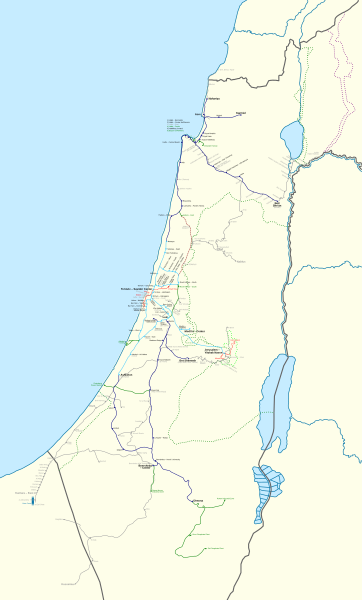
Français : Carte des chemins de fer Israéliens/Palestiniens.
English: This map shows all railways that have been operated by Palestine Railways, Israel Railways, or have existed on the territory of Israel/Palestine.
Certain sources show more train stations at:
I could not find a secondary source, and so they have been left out. There might also have been a Haifa-Wadi Rushmiya line. The station at Birein was probably more of a simple water refilling stop; this is possibly the same for other former stops in the Negev. The J'slm - El Bireh line was a military railway built by the British in 1918 to supply the war front North of Jerusalem. Very little information is available on it, and so its path is very hypothetical; this is also true for other lines (mostly in the Negev). Names: I tried to put former names where possible (space permitting). A plethora of translations, transliterations, and transcriptions exist when romanising Hebrew and Arabic station names. Since this map is in English, I have preferred the name that appeared the most "English" in my eyes. For clarity, a hyphen "-" is used to separate the town name from a qualifier. Borders: Undisputed borders 1949 Green line 1974 Purple line East Jerusalem municipal borders
Train Lines: Open (electrified) Open Open (freight only) Being built Closed |
| Дата | |
| Источник |
|
| Автор | Mapeh |
| Другие версии |
A bigger version of this map exists: Israeli-Palestinian Railways (Full).svg. The source code for both is exactly the same: the only differences between the two are the boundaries (this map has smaller boundaries, therefore "cutting off" the empty parts: the Negev, the Sinai, and the Mediterranean), and which layers are visible (this map shows a schematic version of the Sinai Railway, while the full map shows a geographically accurate version). |
.svg)
Лицензирование
- Вы можете свободно:
- делиться произведением – копировать, распространять и передавать данное произведение
- создавать производные – переделывать данное произведение
- При соблюдении следующих условий:
- атрибуция – Вы должны указать авторство, предоставить ссылку на лицензию и указать, внёс ли автор какие-либо изменения. Это можно сделать любым разумным способом, но не создавая впечатление, что лицензиат поддерживает вас или использование вами данного произведения.
- распространение на тех же условиях – Если вы изменяете, преобразуете или создаёте иное произведение на основе данного, то обязаны использовать лицензию исходного произведения или лицензию, совместимую с исходной.
История файла
Нажмите на дату/время, чтобы посмотреть файл, который был загружен в тот момент.
| Дата/время | Миниатюра | Размеры | Участник | Примечание | |
|---|---|---|---|---|---|
| текущий | 20:33, 16 сентября 2023 | | 1660 × 2748 (592 Кб) | Crash48 | Eastern Railway being rebuilt: https://www.jpost.com/business-and-innovation/article-738891 |
| 06:22, 23 августа 2023 |  | 1660 × 2748 (592 Кб) | Crash48 | +names of Bnei Brak – Ramat HaHayal (Tel Aviv – North) | |
| 08:39, 22 августа 2023 |  | 1660 × 2748 (591 Кб) | Crash48 | Netanya-Lod-Ashkelon electrified | |
| 19:48, 21 августа 2023 |  | 1660 × 2748 (591 Кб) | Crash48 | +Dor/Tantura, Zikhron Yaakov, Jaffa Docks | |
| 22:26, 18 августа 2023 |  | 1660 × 2748 (588 Кб) | Crash48 | +Red LRT lines | |
| 10:20, 4 июня 2022 |  | 1660 × 2748 (567 Кб) | Glide08 | Updated to mark the Herzliya-Sharon-Ashkelon and Jerusalem-Modi'in electrified lines | |
| 23:05, 3 ноября 2021 |  | 1660 × 2748 (566 Кб) | Glide08 | Updated to mark electrified lines as a separate color, and reflect on the extension of the Sharon Railway to Herzliya and the closure of the Beit Shemesh-Malha railway. | |
| 17:41, 2 мая 2020 |  | 1660 × 2748 (574 Кб) | Mapeh | Minor: fixed color of Mazkeret Batya station label | |
| 18:43, 17 марта 2020 |  | 1660 × 2748 (551 Кб) | Mapeh | Corrected the color of Mazkeret Batya station | |
| 14:32, 18 августа 2019 |  | 1660 × 2748 (574 Кб) | My another account | 1) w:Mazkeret Batya railway station opened on 30/05/2019; 2) Change font for Nahariya to mark it as terminus; 3) Wilhelma was a separate station from Rantiya; 4) Tzrifin and Tel HaShomer stations were out of use by the time these settlements got their modern names. |
Использование файла
Следующие 2 страницы используют этот файл:
Глобальное использование файла
Данный файл используется в следующих вики:
- Использование в ar.wikipedia.org
- Использование в de.wikipedia.org
- Использование в en.wikipedia.org
- Использование в he.wikipedia.org
- Использование в hu.wikipedia.org
- Использование в www.wikidata.org