Перейти на страницу файла на Викискладе

Файл:Ocean drainage.png

Материал из Википедии — свободной энциклопедии
Перейти к навигации Перейти к поиску

Исходный файл(1256 × 656 пкс, размер файла: 75 Кб, MIME-тип: image/png)

Краткое описание

Эту карту желательно воссоздать или аккуратно преобразовать в векторный формат SVG. Это даёт несколько преимуществ, прочитать о которых подробнее вы можете на странице Commons:Media for cleanup. Если вам уже сейчас доступна векторная версия данного изображения, загрузите её, пожалуйста, а затем замените этот шаблон на следующий: {{Vector version available|Имя загруженного файла.svg}}.
Описание
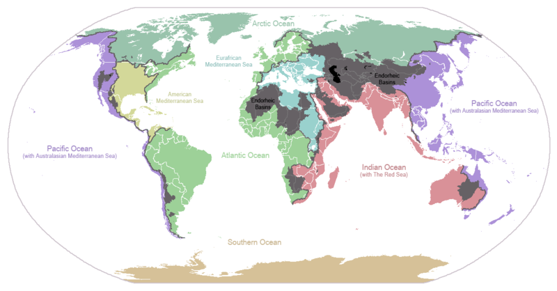
English: I made this map and hereby release it into the public domain. It shows the drainage basins for the major oceans and seas; grey areas are endorheic basins that do not drain to the ocean. Data is from the USGS Hydro1k project; information for Saskatchewan corrected by information from the Commission for Environmental Cooperation -- Citynoise
Description in large font size is used for oceans, in smaller font size is used for mediterranean seas. Only these mediterranean seas are listed which correspond to the definition of german Geographer Ernst Neef: A mediterranean sea is a sea between two Continents. Also found here: de:Mittelmeer --W like wiki (talk) 00:55, 12 March 2011 (UTC)
Français : Carte du monde des bassins versants. Les zones de couleur anthracite représentent les bassins endoréiques, qui ne sont reliés à aucun océan.
Čeština: Úmoří světových oceánů, popř. významných moří či zálivů. Legenda úmoří: fialová - Tichý oceán, růžová - Indický oceán, zelená - Atlantický oceán, azurová - Severní ledový oceán, béžová - Jižní oceán, modrá - Mexický záliv, světle modrá - Středozemní moře, šedá - oblast neústící ve světovém oceánu
Дата 24 января 2007 (дата первоначальной загрузки файла на вики)
Источник Перенесено с en.wikipedia на Викисклад.
Автор Citynoise из английский Википедия
Другие версии File:Major endorheic basins.png

Лицензирование

Public domain Автор этого произведения, Citynoise из английский Википедия, передаёт его в общественное достояние. Это разрешение действует по всему миру.
В некоторых странах это не может быть возможно юридически, в таком случае:
Citynoise предоставляет любому право использовать данное произведение в любых целях, без каких-либо условий, если только такие условия не требуются по закону.

Исходный журнал загрузок

Первоначальная страница описания находилась здесь. Все нижеперечисленные имена участников относятся к en.wikipedia.
  • 2007-05-20 17:59 Bolonium 1256×656×8 (50194 bytes) I made this map and hereby release it into the public domain. It shows the drainage basins for the major oceans and seas; grey areas are endorheic basins that do not drain to the ocean. -- [[User:Citynoise|Citynoise]] == Licensing == {{self
  • 2007-01-24 07:21 Citynoise 1256×656×8 (63359 bytes) I made this map and hereby release it into the public domain. It shows the drainage basins for the major oceans and seas; grey areas are endorheic basins that do not drain to the ocean.
  • 2007-01-24 06:09 Citynoise 1256×656×8 (57358 bytes) I made this map and hereby release it into the public domain. It shows the drainage basins for the major oceans and seas; grey areas are endorheic basins that do not drain to the ocean.
  • 2007-01-24 05:10 Citynoise 1256×656×8 (56360 bytes) I made this map and hereby release it into the public domain. It shows the drainage basins for the major oceans and seas; grey areas are endorheic basins that do not drain to the ocean.
  • 2007-01-24 04:55 Citynoise 1256×656×8 (56373 bytes) I made this map and hereby release it into the public domain. It shows the drainage basins for the major oceans and seas; grey areas are endorheic basins that do not drain to the ocean.

Краткие подписи

Добавьте однострочное описание того, что собой представляет этот файл
Drainage basins of the world, colored by ocean outlet. Endorheic basins not draining to an ocean are colored dark gray. Continental divides are indicated by dark lines.

Элементы, изображённые на этом файле

изображённый объект

История файла

Нажмите на дату/время, чтобы посмотреть файл, который был загружен в тот момент.

Дата/времяМиниатюраРазмерыУчастникПримечание
текущий23:25, 6 октября 2015Миниатюра для версии от 23:25, 6 октября 20151256 × 656 (75 Кб)AcidSnowFixed Somalia.
00:39, 12 марта 2011Миниатюра для версии от 00:39, 12 марта 20111256 × 656 (76 Кб)W like wikiInsert Description. Big font size is used for oceans, smaller font size is used for mediterranean seas.
11:13, 30 июня 2009Миниатюра для версии от 11:13, 30 июня 20091256 × 656 (40 Кб)U7vGuntransparentize background,improve some details.
20:45, 26 июля 2008Миниатюра для версии от 20:45, 26 июля 20081256 × 656 (62 Кб)Citynoise{{Information |Description=added endorheic basins in Saskatchewan. |Source=my own work |Date=July 2008 |Author=Citynoise |Permission=all rights released |other_versions= }}
19:46, 27 ноября 2007Миниатюра для версии от 19:46, 27 ноября 20071256 × 656 (49 Кб)File Upload Bot (Magnus Manske) {{BotMoveToCommons|en.wikipedia}} {{Information |Description={{en|I made this map and hereby release it into the public domain. It shows the drainage basins for the major oceans and seas; grey areas are en:endorheic basins that do not drain to the

Глобальное использование файла

Данный файл используется в следующих вики:

Просмотреть глобальное использование этого файла.

Метаданные