Файл:Starbucks footprint.png
Перейти к навигации
Перейти к поиску

Размер этого предпросмотра: 800 × 417 пкс. Другие разрешения: 320 × 167 пкс | 640 × 333 пкс | 1024 × 534 пкс | 1280 × 667 пкс | 2560 × 1334 пкс | 4858 × 2531 пкс.
Исходный файл (4858 × 2531 пкс, размер файла: 2,25 МБ, MIME-тип: image/png)
Этот файл находится на Викискладе. Сведения о нём показаны ниже.
Викисклад — централизованное хранилище для свободных файлов, используемых в проектах Викимедиа.
|
Краткое описание
|
|
Point Maps
══▻ FAQ ◅══ ══▻ Create your own ◅══ |
Лицензирование
Этот файл доступен по лицензии Creative Commons Attribution-Share Alike 3.0 Unported.
- Вы можете свободно:
- делиться произведением – копировать, распространять и передавать данное произведение
- создавать производные – переделывать данное произведение
- При соблюдении следующих условий:
- атрибуция – Вы должны указать авторство, предоставить ссылку на лицензию и указать, внёс ли автор какие-либо изменения. Это можно сделать любым разумным способом, но не создавая впечатление, что лицензиат поддерживает вас или использование вами данного произведения.
- распространение на тех же условиях – Если вы изменяете, преобразуете или создаёте иное произведение на основе данного, то обязаны использовать лицензию исходного произведения или лицензию, совместимую с исходной.
Исходный журнал загрузок
This image is a derivative work of the following images:
- File:Bahamas location map.svg licensed with Cc-by-sa-3.0, GFDL
- 2008-10-23T19:17:05Z NordNordWest 1560x1125 (562379 Bytes) {{Information |Description= {{de|Positionskarte der [[:de:Bahamas|Bahamas]]}} Quadratische Plattkarte, N-S-Streckung 105 %. Geographische Begrenzung der Karte: * N: 27.5° N * S: 20.7° N * W: 80.7° W * O: 70.8° W {{en|Loca
- File:Canada Quebec location map.svg licensed with Cc-by-sa-3.0
- 2009-08-31T19:03:59Z NordNordWest 2316x2822 (2571526 Bytes) {{int:filedesc}} {{Information |Description= {{de|Positionskarte von [[:de:Québec|Québec]], [[:de:Kanada|Kanada]]}} Quadratische Plattkarte, N-S-Streckung 165 %. Geographische Begrenzung der Karte: * N: 62.8° N * S: 44.7°
- File:Canada Ontario location map.svg licensed with Cc-by-sa-3.0
- 2009-08-31T19:05:05Z NordNordWest 2032x2314 (1376421 Bytes)
- 2009-08-26T10:26:50Z NordNordWest 2032x2314 (1347915 Bytes) {{int:filedesc}} {{Information |Description= {{de|Positionskarte von [[:de:Ontario|Ontario]], [[:de:Kanada|Kanada]]}} Quadratische Plattkarte, N-S-Streckung 155 %. Geographische Begrenzung der Karte: * N: 57.1° N * S: 41.3°
- File:USA Maine location map.svg licensed with Cc-by-3.0, GFDL
- 2009-06-26T15:53:49Z Alexrk2 820x1250 (620502 Bytes) == Beschreibung == {{Information |Description= {{de|Positionskarte von [[:de:Maine|Maine]], [[:de:USA|USA]]}} Quadratische Plattkarte, N-S-Streckung 140.0 %. Geographische Begrenzung der Karte: * N: 47.7° N * S: 42.7° N * W
- File:USA New Hampshire location map.svg licensed with Cc-by-3.0, GFDL
- 2009-06-26T15:37:26Z Alexrk2 639x1120 (257053 Bytes) == Beschreibung == {{Information |Description= {{de|Positionskarte von [[:de:New Hampshire|New Hampshire]], [[:de:USA|USA]]}} Quadratische Plattkarte, N-S-Streckung 140.0 %. Geographische Begrenzung der Karte: * N: 45.5° N *
- File:USA Vermont location map.svg licensed with Cc-by-3.0, GFDL
- 2009-06-14T11:53:24Z Alexrk2 1277x2100 (265267 Bytes) minor enh
- 2009-06-14T11:17:38Z Alexrk2 1277x2100 (262625 Bytes) border lines
- 2009-06-13T18:32:56Z Alexrk 681x1120 (201506 Bytes) fixed border overlap
- 2009-06-13T16:23:33Z Alexrk 1022x1680 (102064 Bytes) fix international border
- 2009-06-13T16:05:37Z Alexrk 1022x1680 (103865 Bytes) == Beschreibung == {{Information |Description= {{de|Positionskarte von [[:de:Vermont|Vermont]], [[:de:USA|USA]]}} Quadratische Plattkarte, N-S-Streckung 140.0 %. Geographische Begrenzung der Karte: * N: 45.2° N * S: 42.5° N
- File:USA Massachusetts location map.svg licensed with Cc-by-3.0, GFDL
- 2009-07-05T11:13:36Z Alexrk2 1050x717 (249369 Bytes) resize
- 2009-06-25T19:38:19Z Alexrk2 800x546 (242956 Bytes) == Beschreibung == {{Information |Description= {{de|Positionskarte von [[:de:Massachusetts|Massachusetts]], [[:de:USA|USA]]}} Quadratische Plattkarte, N-S-Streckung 130.0 %. Geographische Begrenzung der Karte: * N: 43.1° N *
- File:USA Rhode Island location map.svg licensed with Cc-by-3.0, GFDL
- 2009-06-11T18:51:35Z NordNordWest 758x1021 (93024 Bytes) {{Information |Description= {{de|Positionskarte von [[:de:Rhode Island|Rhode Island]], [[:de:USA|USA]]}} Quadratische Plattkarte, N-S-Streckung 135 %. Geographische Begrenzung der Karte: * N: 42.2° N * S: 41.0° N * W: 72.1�
- File:USA Connecticut location map.svg licensed with Cc-by-3.0, GFDL
- 2009-06-25T19:16:48Z Alexrk2 800x678 (154250 Bytes) renderer bug
- 2009-06-25T19:14:39Z Alexrk2 800x678 (155149 Bytes) == Beschreibung == {{Information |Description= {{de|Positionskarte von [[:de:Connecticut|Connecticut]], [[:de:USA|USA]]}} Quadratische Plattkarte, N-S-Streckung 130.0 %. Geographische Begrenzung der Karte: * N: 42.3° N * S:
- File:USA New York location map.svg licensed with Cc-by-3.0, GFDL
- 2009-06-10T11:28:20Z NordNordWest 1572x1277 (597043 Bytes) {{Information |Description= {{de|Positionskarte vom Bundesstaat [[:de:New York (Bundesstaat)|New York]], [[:de:USA|USA]]}} Quadratische Plattkarte, N-S-Streckung 135 %. Geographische Begrenzung der Karte: * N: 45.3° N * S: 4
- File:USA New Jersey location map.svg licensed with Cc-by-3.0, GFDL
- 2009-06-17T19:59:27Z Alexrk2 839x1560 (259806 Bytes) enh
- 2009-06-13T18:01:16Z Alexrk 839x1560 (198653 Bytes) fixed SVG bug
- 2009-06-13T17:46:17Z Alexrk 839x1560 (246056 Bytes) == Beschreibung == {{Information |Description= {{de|Positionskarte von [[:de:New Jersey|New Jersey]], [[:de:USA|USA]]}} Quadratische Plattkarte, N-S-Streckung 130.0 %. Geographische Begrenzung der Karte: * N: 41.6° N * S: 38
- File:USA Pennsylvania location map.svg licensed with Cc-by-3.0, GFDL
- 2009-07-05T11:11:22Z Alexrk2 1201x805 (429769 Bytes) == Beschreibung == {{Information |Description= {{de|Positionskarte von [[:de:Pennsylvania|Pennsylvania]], [[:de:USA|USA]]}} Quadratische Plattkarte, N-S-Streckung 130.0 %. Geographische Begrenzung der Karte: * N: 42.7° N * S
- File:USA Delaware location map.svg licensed with Cc-by-3.0, GFDL
- 2009-06-22T10:54:18Z Alexrk2 470x800 (106507 Bytes) renderer bug
- 2009-06-22T10:39:54Z Alexrk2 470x800 (66078 Bytes) == Beschreibung == {{Information |Description= {{de|Positionskarte von [[:de:Delaware|Delaware]], [[:de:USA|USA]]}} Quadratische Plattkarte, N-S-Streckung 130.0 %. Geographische Begrenzung der Karte: * N: 40.0° N * S: 38.3°
- File:USA Maryland location map.svg licensed with Cc-by-3.0, GFDL
- 2009-06-22T11:30:38Z Alexrk2 1200x764 (463352 Bytes) fixed border
- 2009-06-22T11:23:05Z Alexrk2 1200x764 (459278 Bytes) crop height
- 2009-06-22T11:03:54Z Alexrk2 1201x955 (455501 Bytes) renderer bug
- 2009-06-22T10:42:06Z Alexrk2 800x636 (318450 Bytes) == Beschreibung == {{Information |Description= {{de|Positionskarte von [[:de:Maryland|Maryland]], [[:de:USA|USA]]}} Quadratische Plattkarte, N-S-Streckung 130.0 %. Geographische Begrenzung der Karte: * N: 40.3° N * S: 37.3°
- File:USA Virginia location map.svg licensed with Cc-by-3.0, GFDL
- 2009-07-06T18:02:25Z Alexrk2 1500x964 (963271 Bytes) resize
- 2009-06-26T16:42:40Z Alexrk2 1201x772 (966691 Bytes) == Beschreibung == {{Information |Description= {{de|Positionskarte von [[:de:Virginia|Virginia]], [[:de:USA|USA]]}} Quadratische Plattkarte, N-S-Streckung 130.0 %. Geographische Begrenzung der Karte: * N: 40.2° N * S: 35.8°
- File:USA North Carolina location map.svg licensed with Cc-by-3.0, GFDL
- 2010-04-25T12:44:25Z Alexrk2 1400x849 (1201046 Bytes) enh rivers, aligned state borders
- 2009-06-26T22:06:53Z Alexrk2 1400x849 (894030 Bytes) resize
- 2009-06-26T21:57:18Z Alexrk2 1400x849 (896940 Bytes) resize
- 2009-06-26T21:47:07Z Alexrk2 1201x728 (930560 Bytes) == Beschreibung == {{Information |Description= {{de|Positionskarte von [[:de:North Carolina|North Carolina]], [[:de:USA|USA]]}} Quadratische Plattkarte, N-S-Streckung 120.0 %. Geographische Begrenzung der Karte: * N: 37.5° N
- File:USA South Carolina location map.svg licensed with Cc-by-3.0, GFDL
- 2009-06-20T11:32:20Z Alexrk2 1200x978 (494031 Bytes) simpl water polygons
- 2009-06-20T11:30:37Z Alexrk2 1200x978 (499688 Bytes) simpl water polygons
- 2009-06-20T10:51:24Z Alexrk2 1200x978 (557792 Bytes) == Beschreibung == {{Information |Description= {{de|Positionskarte von [[:de:South Carolina|South Carolina]], [[:de:USA|USA]]}} Quadratische Plattkarte, N-S-Streckung 120.0 %. Geographische Begrenzung der Karte: * N: 35.4° N
- File:USA Georgia location map.svg licensed with Cc-by-3.0, GFDL
- 2009-06-20T11:26:27Z Alexrk2 1201x1384 (778454 Bytes) == Beschreibung == {{Information |Description= {{de|Positionskarte von [[:de:Georgia|Georgia]], [[:de:USA|USA]]}} Quadratische Plattkarte, N-S-Streckung 120.0 %. Geographische Begrenzung der Karte: * N: 35.2° N * S: 30.2° N
- File:USA Florida location map.svg licensed with Cc-by-3.0
- 2008-12-15T20:25:08Z Sting 1132x1096 (591820 Bytes) Counties boundaries: thinner strokes
- 2008-12-15T19:49:40Z Sting 1132x1096 (591829 Bytes) == Summary == {{Location|27|45|00|N|83|49|30|W|scale:4000000}} {{Information |Description={{en|Blank administrative map of the State of [[:en:Florida|Florida]], [[:en:United States|USA]], for geo-location purpose, with count
- File:USA West Virginia location map.svg licensed with Cc-by-3.0, GFDL
- 2009-07-03T15:31:49Z Alexrk2 1201x1118 (535137 Bytes) == Beschreibung == {{Information |Description= {{de|Positionskarte von [[:de:West Virginia|West Virginia]], [[:de:USA|USA]]}} Quadratische Plattkarte, N-S-Streckung 130.0 %. Geographische Begrenzung der Karte: * N: 40.8° N *
- File:USA Ohio location map.svg licensed with Cc-by-3.0, GFDL
- 2009-06-26T19:16:16Z Alexrk2 1010x1200 (465438 Bytes) == Beschreibung == {{Information |Description= {{de|Positionskarte von [[:de:Ohio|Ohio]], [[:de:USA|USA]]}} Quadratische Plattkarte, N-S-Streckung 130.0 %. Geographische Begrenzung der Karte: * N: 42.5° N * S: 38.2° N * W:
- File:USA Michigan location map.svg licensed with Cc-by-3.0, GFDL
- 2009-06-21T16:41:07Z Alexrk2 1066x1200 (657268 Bytes) Isle Royale
- 2009-06-21T11:39:57Z Alexrk2 1066x1200 (668111 Bytes) fixed borders
- 2009-06-21T11:30:04Z Alexrk2 1066x1200 (675974 Bytes) water lines
- 2009-06-21T11:21:34Z Alexrk2 1066x1200 (738759 Bytes) water lines
- 2009-06-21T11:02:31Z Alexrk2 1066x1200 (849542 Bytes) simp water polygons
- 2009-06-21T10:51:51Z Alexrk2 1066x1200 (860414 Bytes) == Beschreibung == {{Information |Description= {{de|Positionskarte von [[:de:Michigan|Michigan]], [[:de:USA|USA]]}} Quadratische Plattkarte, N-S-Streckung 140.0 %. Geographische Begrenzung der Karte: * N: 48.5° N * S: 41.5°
- File:USA Kentucky location map.svg licensed with Cc-by-3.0, GFDL
- 2009-09-03T14:45:55Z Alexrk2 1501x976 (842602 Bytes) == Beschreibung == {{Information |Description= {{de|Positionskarte von [[:de:Kentucky|Kentucky]], [[:de:USA|USA]]}} Quadratische Plattkarte, N-S-Streckung 130.0 %. Geographische Begrenzung der Karte: * N: 39.8° N * S: 35.8°
- File:USA Tennessee location map.svg licensed with Cc-by-3.0, GFDL
- 2009-06-20T10:17:47Z Alexrk2 1800x1068 (1214390 Bytes) page ratio, water bodies
- 2009-06-13T16:00:05Z Alexrk 1500x415 (251640 Bytes) == Beschreibung == {{Information |Description= {{de|Positionskarte von [[:de:Tennessee|Tennessee]], [[:de:USA|USA]]}} Quadratische Plattkarte, N-S-Streckung 120.0 %. Geographische Begrenzung der Karte: * N: 36.9° N * S: 34.8
- File:USA Indiana location map.svg licensed with Cc-by-3.0, GFDL
- 2009-07-09T16:13:52Z Alexrk2 776x1200 (557512 Bytes) == Beschreibung == {{Information |Description= {{de|Positionskarte von [[:de:Indiana|Indiana]], [[:de:USA|USA]]}} Quadratische Plattkarte, N-S-Streckung 130.0 %. Geographische Begrenzung der Karte: * N: 42.0° N * S: 37.6° N
- File:USA Alabama location map.svg licensed with Cc-by-3.0, GFDL
- 2009-06-20T11:57:26Z Alexrk2 754x1200 (583213 Bytes) == Beschreibung == {{Information |Description= {{de|Positionskarte von [[:de:Alabama|Alabama]], [[:de:USA|USA]]}} Quadratische Plattkarte, N-S-Streckung 120.0 %. Geographische Begrenzung der Karte: * N: 35.2° N * S: 29.9° N
- File:USA Wisconsin location map.svg licensed with Cc-by-3.0, GFDL
- 2009-07-03T10:10:36Z Alexrk2 1171x1200 (620102 Bytes) == Beschreibung == {{Information |Description= {{de|Positionskarte von [[:de:Wisconsin|Wisconsin]], [[:de:USA|USA]]}} Quadratische Plattkarte, N-S-Streckung 140.0 %. Geographische Begrenzung der Karte: * N: 47.5° N * S: 42.3
- File:USA Illinois location map.svg licensed with Cc-by-3.0, GFDL
- 2009-07-10T16:59:00Z Alexrk2 945x1250 (798981 Bytes) == Beschreibung == {{Information |Description= {{de|Positionskarte von [[:de:Illinois|Illinois]], [[:de:USA|USA]]}} Quadratische Plattkarte, N-S-Streckung 130.0 %. Geographische Begrenzung der Karte: * N: 42.7° N * S: 36.8°
- File:USA Mississippi location map.svg licensed with Cc-by-3.0, GFDL
- 2009-06-20T12:33:16Z Alexrk2 754x1200 (634259 Bytes) == Beschreibung == {{Information |Description= {{de|Positionskarte von [[:de:Mississippi|Mississippi]], [[:de:USA|USA]]}} Quadratische Plattkarte, N-S-Streckung 120.0 %. Geographische Begrenzung der Karte: * N: 35.2° N * S:
- File:USA Minnesota location map.svg licensed with Cc-by-3.0, GFDL
- 2009-06-21T12:06:23Z Alexrk2 1029x1200 (713890 Bytes) simp water
- 2009-06-21T11:53:30Z Alexrk2 1029x1200 (716629 Bytes) == Beschreibung == {{Information |Description= {{de|Positionskarte von [[:de:Minnesota|Minnesota]], [[:de:USA|USA]]}} Quadratische Plattkarte, N-S-Streckung 150.0 %. Geographische Begrenzung der Karte: * N: 49.6° N * S: 43.3
- File:USA Iowa location map.svg licensed with Cc-by-3.0, GFDL
- 2009-07-20T08:12:26Z Alexrk2 1201x791 (493408 Bytes) == Beschreibung == {{Information |Description= {{de|Positionskarte von [[:de:Iowa|Iowa]], [[:de:USA|USA]]}} Quadratische Plattkarte, N-S-Streckung 130.0 %. Geographische Begrenzung der Karte: * N: 43.7° N * S: 40.2° N * W:
- File:USA Missouri location map.svg licensed with Cc-by-3.0, GFDL
- 2009-10-03T12:17:01Z Alexrk2 1401x1282 (873194 Bytes) minor fixes
- 2009-10-03T12:03:22Z Alexrk2 1401x1282 (765713 Bytes) == Beschreibung == {{Information |Description= {{de|Positionskarte von [[:de:Missouri|Missouri]], [[:de:USA|USA]]}} Quadratische Plattkarte, N-S-Streckung 130.0 %. Geographische Begrenzung der Karte: * N: 40.8° N * S: 35.8°
- File:USA Arkansas location map.svg licensed with Cc-by-3.0, GFDL
- 2009-12-17T20:12:02Z Alexrk2 1201x1040 (534853 Bytes) minor enh.
- 2009-06-20T16:37:13Z Alexrk2 1201x1040 (623516 Bytes) fixed bbox
- 2009-06-20T13:13:10Z Alexrk2 1201x1147 (596860 Bytes) fixed page size
- 2009-06-20T13:12:13Z Alexrk2 800x764 (588375 Bytes) == Beschreibung == {{Information |Description= {{de|Positionskarte von [[:de:Arkansas|Arkansas]], [[:de:USA|USA]]}} Quadratische Plattkarte, N-S-Streckung 120.0 %. Geographische Begrenzung der Karte: * N: 36.7° N * S: 32.8°
- File:USA Louisiana location map.svg licensed with Cc-by-3.0, GFDL
- 2009-07-07T14:38:22Z Alexrk2 1201x1157 (830506 Bytes) == Beschreibung == {{Information |Description= {{de|Positionskarte von [[:de:Louisiana|Louisiana]], [[:de:USA|USA]]}} Quadratische Plattkarte, N-S-Streckung 120.0 %. Geographische Begrenzung der Karte: * N: 33.2° N * S: 28.7
- File:USA North Dakota location map.svg licensed with Cc-by-3.0, GFDL
- 2009-06-21T09:59:23Z Alexrk2 1201x891 (354825 Bytes) water 2m
- 2009-06-13T16:31:01Z Alexrk 1500x996 (126550 Bytes) == Beschreibung == {{Information |Description= {{de|Positionskarte von [[:de:North Dakota|North Dakota]], [[:de:USA|USA]]}} Quadratische Plattkarte, N-S-Streckung 150.0 %. Geographische Begrenzung der Karte: * N: 49.2° N * S
- File:USA South Dakota location map.svg licensed with Cc-by-3.0, GFDL
- 2009-06-19T18:37:25Z Alexrk2 1200x788 (395277 Bytes) fixed water
- 2009-06-13T16:02:03Z Alexrk 1500x985 (124481 Bytes) == Beschreibung == {{Information |Description= {{de|Positionskarte von [[:de:South Dakota|South Dakota]], [[:de:USA|USA]]}} Quadratische Plattkarte, N-S-Streckung 140.0 %. Geographische Begrenzung der Karte: * N: 46.1° N * S
- File:USA Nebraska location map.svg licensed with Cc-by-3.0, GFDL
- 2009-10-03T12:53:46Z Alexrk2 1201x779 (532369 Bytes) == Beschreibung == {{Information |Description= {{de|Positionskarte von [[:de:Nebraska|Nebraska]], [[:de:USA|USA]]}} Quadratische Plattkarte, N-S-Streckung 130.0 %. Geographische Begrenzung der Karte: * N: 43.8° N * S: 39.2°
- File:USA Kansas location map.svg licensed with Cc-by-3.0, GFDL
- 2009-09-03T14:24:10Z Alexrk2 1400x783 (380992 Bytes) == Beschreibung == {{Information |Description= {{de|Positionskarte von [[:de:Kansas|Kansas]], [[:de:USA|USA]]}} Quadratische Plattkarte, N-S-Streckung 130.0 %. Geographische Begrenzung der Karte: * N: 40.2° N * S: 36.8° N *
- File:USA Oklahoma location map.svg licensed with Cc-by-3.0, GFDL
- 2009-06-19T18:15:30Z Alexrk2 1500x760 (677692 Bytes) fixed page size
- 2009-06-19T18:12:51Z Alexrk2 1200x608 (666655 Bytes) corr
- 2009-06-14T12:37:44Z Alexrk2 1500x760 (502978 Bytes) enh
- 2009-06-13T14:03:10Z Alexrk2 1500x760 (203653 Bytes) == Beschreibung == {{Information |Description= {{de|Positionskarte von [[:de:Oklahoma|Oklahoma]], [[:de:USA|USA]]}} Quadratische Plattkarte, N-S-Streckung 120.0 %. Geographische Begrenzung der Karte: * N: 37.2° N * S: 33.4°
- File:USA Texas location map.svg licensed with Cc-by-3.0, GFDL
- 2009-06-17T20:30:36Z Alexrk2 1500x1484 (711918 Bytes) enh
- 2009-06-07T13:05:09Z Alexrk 1500x1484 (571429 Bytes) water bodies 1:10mio
- 2009-06-06T21:43:21Z Alexrk 1500x1484 (870861 Bytes) GeneralizationDistance = 2px
- 2009-06-06T17:41:11Z Alexrk 1500x1485 (1550930 Bytes) == Beschreibung == {{Information |Description= {{de|Positionskarte von [[:de:Texas|Texas]], [[:de:USA|USA]]}} Quadratische Plattkarte, N-S-Streckung 120 %. Geographische Begrenzung der Karte: * N: 36.8° N * S: 25.5° N * W:
- File:USA Montana location map.svg licensed with Cc-by-3.0, GFDL
- 2009-07-02T15:39:52Z Alexrk2 1201x893 (651448 Bytes) == Beschreibung == {{Information |Description= {{de|Positionskarte von [[:de:Montana|Montana]], [[:de:USA|USA]]}} Quadratische Plattkarte, N-S-Streckung 150.0 %. Geographische Begrenzung der Karte: * N: 49.8° N * S: 43.6° N
- File:USA Wyoming location map.svg licensed with Cc-by-3.0, GFDL
- 2009-06-13T14:16:14Z Alexrk 1500x1248 (79207 Bytes) == Beschreibung == {{Information |Description= {{de|Positionskarte von [[:de:Wyoming|Wyoming]], [[:de:USA|USA]]}} Quadratische Plattkarte, N-S-Streckung 140.0 %. Geographische Begrenzung der Karte: * N: 45.2° N * S: 40.8° N
- File:USA Colorado location map.svg licensed with Cc-by-3.0, GFDL
- 2009-06-12T18:06:33Z NordNordWest 1067x783 (186915 Bytes) {{Information |Description= {{de|Positionskarte von [[:de:Colorado|Colorado]], [[:de:USA|USA]]}} Quadratische Plattkarte, N-S-Streckung 125 %. Geographische Begrenzung der Karte: * N: 41.2° N * S: 36.8° N * W: 109.3° W * O
- File:USA New Mexico location map.svg licensed with Cc-by-3.0, GFDL
- 2009-10-02T15:48:01Z Alexrk2 1245x1401 (236402 Bytes) == Beschreibung == {{Information |Description= {{de|Positionskarte von [[:de:New Mexico|New Mexico]], [[:de:USA|USA]]}} Quadratische Plattkarte, N-S-Streckung 120.0 %. Geographische Begrenzung der Karte: * N: 37.2° N * S: 31
- File:USA Idaho location map.svg licensed with Cc-by-3.0, GFDL
- 2009-07-23T18:26:31Z Alexrk2 915x1200 (625293 Bytes) == Beschreibung == {{Information |Description= {{de|Positionskarte von [[:de:Idaho|Idaho]], [[:de:USA|USA]]}} Quadratische Plattkarte, N-S-Streckung 140.0 %. Geographische Begrenzung der Karte: * N: 49.2° N * S: 41.8° N * W
- File:USA Utah location map.svg licensed with Cc-by-3.0, GFDL
- 2009-06-09T18:09:47Z NordNordWest 868x1031 (179195 Bytes) {{Information |Description= {{de|Positionskarte von [[:de:Utah|Utah]], [[:de:USA|USA]]}} Quadratische Plattkarte, N-S-Streckung 125 %. Geographische Begrenzung der Karte: * N: 42.4° N * S: 36.6° N * W: 114.6° W * O: 108.5�
- File:USA Arizona location map.svg licensed with Cc-by-sa-3.0
- 2009-06-22T12:41:01Z NordNordWest 893x1099 (173532 Bytes) {{Information |Description= {{de|Positionskarte von [[:de:Arizona|Arizona]], [[:de:USA|USA]]}} Quadratische Plattkarte, N-S-Streckung 125 %. Geographische Begrenzung der Karte: * N: 37.3° N * S: 31.1° N * W: 115.0° W * O:
- File:USA Nevada location map.svg licensed with Cc-by-3.0, GFDL
- 2009-06-05T20:03:51Z NordNordWest 882x1297 (123631 Bytes) {{Information |Description= {{de|Positionskarte von [[:de:Nevada|Nevada]], [[:de:USA|USA]]}} Quadratische Plattkarte, N-S-Streckung 125 %. Geographische Begrenzung der Karte: * N: 42.2° N * S: 34.9° N * W: 120.1° W * O: 11
- File:USA Washington location map.svg licensed with Cc-by-3.0, GFDL
- 2009-10-02T16:20:18Z Alexrk2 1501x1057 (574917 Bytes) == Beschreibung == {{Information |Description= {{de|Positionskarte von [[:de:Washington|Washington]], [[:de:USA|USA]]}} Quadratische Plattkarte, N-S-Streckung 150.0 %. Geographische Begrenzung der Karte: * N: 49.2° N * S: 45
- File:USA Oregon location map.svg licensed with Cc-by-3.0, GFDL
- 2009-09-06T21:25:34Z Alexrk2 1501x1148 (419523 Bytes) fixed rivers
- 2009-09-06T21:19:28Z Alexrk2 1501x1148 (421158 Bytes) == Beschreibung == {{Information |Description= {{de|Positionskarte von [[:de:Oregon|Oregon]], [[:de:USA|USA]]}} Quadratische Plattkarte, N-S-Streckung 140.0 %. Geographische Begrenzung der Karte: * N: 46.5° N * S: 41.8° N *
- File:USA California location map.svg licensed with Cc-by-3.0, GFDL
- 2009-06-05T19:17:46Z NordNordWest 1022x1171 (491838 Bytes) more detailed
- 2009-03-12T21:50:35Z NordNordWest 1020x1169 (394722 Bytes) {{Information |Description= {{de|Positionskarte von [[:de:Kalifornien|Kalifornien]], [[:de:USA|USA]]}} Quadratische Plattkarte, N-S-Streckung 125 %. Geographische Begrenzung der Karte: * N: 42.2° N * S: 32.3° N * W: 124.7°
- File:Mexico location map.svg licensed with Cc-by-3.0, GFDL
- 2009-03-11T18:34:05Z NordNordWest 2029x1326 (882028 Bytes) {{Information |Description= {{de|Positionskarte von [[:de:Mexiko|Mexiko]]}} Quadratische Plattkarte, N-S-Streckung 110 %. Geographische Begrenzung der Karte: * N: 33.3° N * S: 14.2° N * W: 118.5° W * O: 86.3° W {{en|Locat
- File:USA_Alaska_location_map.svg licensed with Cc-by-3.0, GFDL
- 2009-10-03T19:13:16Z Alexrk2 1553x1160 (1302399 Bytes) Linien gesäubert
- 2009-10-03T19:03:13Z Alexrk2 1553x1160 (1309280 Bytes) Westlicher Teil korrigiert
- 2009-10-03T18:35:46Z Alexrk2 1553x1160 (1304792 Bytes) == Beschreibung == {{Information |Description= {{de|Positionskarte von [[:de:Alaska|Alaska]], [[:de:USA|USA]]}} Quadratische Plattkarte, N-S-Streckung 210.0 %. Geographische Begrenzung der Karte: * N: 72.0° N * S: 51.0° N *
- File:USA_Hawaii_location_map.svg licensed with Cc-by-sa-3.0-de
- 2009-06-13T18:36:34Z NordNordWest 1441x935 (32246 Bytes) {{Information |Description= {{de|Positionskarte von [[:de:Hawaii|Hawaii]], [[:de:USA|USA]]}} Quadratische Plattkarte, N-S-Streckung 107 %. Geographische Begrenzung der Karte: * N: 22.4° N * S: 18.7° N * W: 160.7° W * O: 15
- File:USA_Puerto_Rico_location_map.svg licensed with Cc-by-sa-3.0
- 2009-06-19T07:13:05Z NordNordWest 1058x595 (117123 Bytes) {{Information |Description= {{de|Positionskarte von [[:de:Puerto Rico|Puerto Rico]], [[:de:USA|USA]]}} Quadratische Plattkarte, N-S-Streckung 105 %. Geographische Begrenzung der Karte: * N: 19.0° N * S: 17.5° N * W: 68.0°
Uploaded with derivativeFX
История файла
Нажмите на дату/время, чтобы посмотреть файл, который был загружен в тот момент.
| Дата/время | Миниатюра | Размеры | Участник | Примечание | |
|---|---|---|---|---|---|
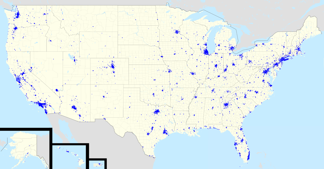
| текущий | 21:39, 7 мая 2012 | | 4858 × 2531 (2,25 МБ) | Magog the Ogre | == {{int:filedesc}} == {{Information |Description={{en|Footprint of en:Starbucks in the United States as of {{ISOdate|2012-02}}.}} |Source={{Derived from|USA_location_map_-_counties.svg|USA_Alaska_location_map.svg|USA_Hawaii_location_map.svg|USA_... |
Использование файла
Следующая страница использует этот файл:
Глобальное использование файла
Данный файл используется в следующих вики:
- Использование в en.wikipedia.org
- Использование в id.wikipedia.org