Файл:1676 John Speed Map of Carolina - Geographicus - Carolina-speed-1676.jpg
Перейти к навигации
Перейти к поиску

Размер этого предпросмотра: 793 × 600 пкс. Другие разрешения: 317 × 240 пкс | 635 × 480 пкс | 1015 × 768 пкс | 1280 × 968 пкс | 2560 × 1937 пкс | 5000 × 3783 пкс.
Исходный файл (5000 × 3783 пкс, размер файла: 5,23 Мб, MIME-тип: image/jpeg)
Этот файл находится на Викискладе. Сведения о нём показаны ниже.
Викисклад — централизованное хранилище для свободных файлов, используемых в проектах Викимедиа.
|
Краткое описание
| A New Description of Carolina. | ||||||
|---|---|---|---|---|---|---|
| Автор | ||||||
| Название |
A New Description of Carolina. |
|||||
| Описание |
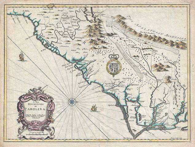
English: A beautiful example of John Speed's important 1676 map of the Carolina colony. Heavily based upon the explorations of John Lederer and Ogilby's Lords Proprietor's Map of 1674. This seminal map represents one of the earliest attempts to map the Carolina interior. Oriented to the West, map covers from the Spanish colony of St. Augustine, Florida, north to Jamestown, Virginia. Extends inland as far as the Appellation (Apalathean) Mountains. By the middle of the 17th century the coast of Carolina had been fairly well mapped , St. Augustine, Port Royal, Charleston (Charles Town), Cape Fear, Cape Lookout, Cape Hatteras, Roanoke, Cape Henry and the James River are all shown with a fair approximation of accuracy. We see ample evidence of the Lords Proprietors including Albemarl County, Clarendon County, Berkley County, Craven County, etc. This map also incorporates numerous elements from earlier maps including Lake Sarrope, which was identified by the De Bry - Le Moyne map of 1565 and most likely represents Lake Okeechobee. Also shows the River May (historically either the St. John's River or the Savannah River, depending on the map). Where this map really gets interesting is the interior, which is heavily based upon the explorations of John Lederer in the 1670s. Lederer, a German physician who had moved to the colony several years before was commissioned by the Lord Proprietor, Anthony Ashley Cooper (Earl of Shaftesbury), to explore the interior in search of a pass beyond the mountains to the Pacific. As the time it was commonly assumed that the mainland of North America was a relatively narrow strip of land that could be traversed swiftly easily to access the rich trade opportunities of the Pacific. Though Lederer never managed to cross the Appellations, he did undertake three voyages which significantly impacted cartography in this region for several hundred years. Today Lederer is highly criticized for fabricating much of his journey and a cursory examination of the map will reveal what might seem to be several gross cartographic errors, including a great savanna in the Piedmont, the Deserta Arensa, and Ashley Lake in the north. Lederer's route is roughly traced on this map as he heads almost directly west from the Falls of the James River before turning southwest at the Mahock village (near Richmond). Keeping to a southwesterly course, Lederer passes a great savanna on his right and ultimately finds himself on the shores of Ashley Lake (which he calls Ushery and which on our map corresponds with the Great Freshwater Lake of the American Southwest popularized by the 1606 Mercator - Hondius Map). At this point Lederer returns along a parallel but more easterly course passing through a great sandy desert, the Deserta Arenosa, before returning to known lands. Many scholars have argued that Lederer simply lied about many of his findings, but we find that much of what he said, when taken in the context of lonely explorer traversing an unknown land several hundred years ago, has merit. Lederer's desert, the Arenosa, probably corresponds the Sand Hills region, though he does slightly exaggerate the scope. Some scholars criticize the desert as, according to his narrative Lederer spent several days on the desert before encountering water. Given the geography of the Sand Hills as we know it, it would seem likely that he would have such difficulty finding water, but his placement of the desert compared with the actual placement of the Sand Hills remains convincing. The savanna in the piedmont region is non-existent today, though something very much like this may have existed in Lederer's day. Lederer describes this savanna as marish grounds at the foot of the Apalataei. |
|||||
| Дата | 1676 (undated) | |||||
| Размеры | высота: 15 дюймов (38,1 см); ширина: 20 дюймов (50,8 см) | |||||
| Инвентарный номер |
Geographicus link: Carolina-speed-1676 |
|||||
| Источник/Фотограф |
Speed, J., The Theater of the Empire of Great Britian, 1676. Also in, Speed, J., A Prospect of the Most Famous Parts fo the World…, 1676.
|
|||||
| Права (Повторное использование этого файла) |
|
|||||
| Другие версии |
.jpg) |
|||||
История файла
Нажмите на дату/время, чтобы посмотреть файл, который был загружен в тот момент.
| Дата/время | Миниатюра | Размеры | Участник | Примечание | |
|---|---|---|---|---|---|
| текущий | 00:20, 23 марта 2011 | | 5000 × 3783 (5,23 Мб) | BotMultichillT | {{subst:User:Multichill/Geographicus |link=http://www.geographicus.com/P/AntiqueMap/Carolina-speed-1676 |product_name=1676 John Speed Map of Carolina |map_title=A New Description of Carolina. |description=A beautiful example of John Speed's important 167 |
Использование файла
Следующая страница использует этот файл:
Глобальное использование файла
Данный файл используется в следующих вики:
- Использование в es.wikipedia.org
- Использование в fr.wikipedia.org