Перейти на страницу файла на Викискладе

Файл:1800 Faden Rennell Wall Map of India - Geographicus - India-faden-1795.jpg

Материал из Википедии — свободной энциклопедии
Перейти к навигации Перейти к поиску

Исходный файл(6000 × 7353 пкс, размер файла: 10,85 МБ, MIME-тип: image/jpeg)

Краткое описание

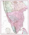
A Map of the Peninsula of India from the 19th Degree North Latitude to Cape Comorin.
Автор
Название
A Map of the Peninsula of India from the 19th Degree North Latitude to Cape Comorin.
Описание
English: This map (noted as "Third Edition"), created immediately after the Fourth Anglo-Mysore War (1798–1799), is based on the 1793 Faden map (without any version note), created immediately after the Third Anglo-Mysore War (1789-92) and the subsequent division of and territorial loss by the Kingdom of Mysore through the 1792 Treaty of Seringapatam. The only difference from the older map is in political territory, showing vast expansion of the territory of the British East India Company (over that gained by the 1792 Treaty of Seringapatam), and the now much smaller Princely State of Mysore, after the Kingdom of Mysore having further lost territory to the East India Company's Madras Presidency, and one of the company's allies in the Anglo-Mysore Wars, the Princely state (from 1798) of Hyderabad state (contemporary sources refer to its hereditary ruler, the Nizam (of Hyderabad) in place of his territories).

The original 1773 map, with this map showing only territorial changes, was, according to the notes on the map, "compiled chiefly from papers communicated by the late Sir Archibald Campbell, the surveys of Col. Kelly, Capt. Pringle, Capt. Allan, etc." by Major James Rennell, and not based on his own surveys as Surveyor-General of the British East India Company, which were conducted in the Ganges basin.

Description from Geographicus: This is James Rennell's magnificent mapping of the Indian subcontinent, one of the largest and most impressive maps of India to appear in the 18th century. Highly desirable third edition. Presented in two panels, as issued. This chart depicts the subcontinent from Bombay ( Mumbai ) and Aurangabad, south including the northern half of Sri Lanka (Ceylon). Color coded according to political territory, noting British Possessions (red), the territory claimed by the independent holdout Rajah of Mysore (Purple), the Marhatta Countries (Green), the Nizam Dominions (Orange), the Carnatick (Yellow), and the Travancore (Blue). Includes the routes of various military marches and campaigns relating to the British conquest of India, including the 1784 March of British Prisoners from Condapoor to Madras, the march of the Marquis of Cornwallis, the march of General Medows, and the march of General Abercromby. Also shows the acquisitions of the British through the Partition Treaty of 1792. This map was engraved by R. Baker and printed in by William Faden, “Royal Geographer to the King and to the Prince of Wales”. The whole is masterfully presented in visually stunning almost three dimensional engraving and stunning period color. A must for any serious collection of South Asia maps. Compiled by James Rennell from papers communicated by the late Sir Archibald Campbell, the surveys of Col. Kelly, Capt. Pringle, Capt. Allan, etc.
Дата 1800 (dated)
Размеры высота: 40 дюймов (101,6 см); ширина: 33 дюймов (83,8 см)
dimensions QS:P2048,40U218593
dimensions QS:P2049,33U218593
Инвентарный номер
Geographicus link: India-faden-1795
Источник/Фотограф

Faden, W., General Atlas, 1800.

Другие версии

Лицензирование

Это изображение является точной фотографической репродукцией оригинального двумерного произведения изобразительного искусства. Данное произведение изобразительного искусства само по себе находится в общественном достоянии по следующей причине:
Public domain

Это произведение находится в общественном достоянии в тех странах, где срок охраны авторского права равен жизни автора плюс 100 лет и менее.


Вы также должны пометить это произведение одним из шаблонов общественного достояния США, чтобы указать причину, по которой оно находится в статусе общественного достояния в США.
Официальная позиция, занятая «Фондом Викимедиа», заключается в том, что «точные репродукции двумерных произведений изобразительного искусства, находящихся в общественном достоянии, также находятся в общественном достоянии, и заявления об обратном представляют собой нападки на саму концепцию общественного достояния». Для получения подробной информации см. Commons:Когда использовать тег PD-Art.
Эта фотографическая репродукция, следовательно, также считается находящейся в общественном достоянии. Просим учитывать, что в зависимости от местного законодательства повторное использование этого контента может быть запрещено или ограничено в вашей юрисдикции. См. Commons:Когда использовать тег PD-Art.

Краткие подписи

Добавьте однострочное описание того, что собой представляет этот файл

Элементы, изображённые на этом файле

изображённый объект

image/jpeg

11 372 962 байт

7353 пиксель

6000 пиксель

История файла

Нажмите на дату/время, чтобы посмотреть файл, который был загружен в тот момент.

Дата/времяМиниатюраРазмерыУчастникПримечание
текущий02:00, 24 марта 2011Миниатюра для версии от 02:00, 24 марта 20116000 × 7353 (10,85 МБ)BotMultichillT{{subst:User:Multichill/Geographicus |link=http://www.geographicus.com/P/AntiqueMap/India-faden-1795 |product_name=1800 Faden Rennell Wall Map of India |map_title=A Map of the Peninsula of India from the 19th Degree North Latitude to Cape Comorin. |descri

Следующая страница использует этот файл:

Глобальное использование файла

Данный файл используется в следующих вики: