Перейти на страницу файла на Викискладе

Файл:2024-uk-election-by-region-and-nation-full.svg

Материал из Википедии — свободной энциклопедии
Перейти к навигации Перейти к поиску

Исходный файл(SVG-файл, номинально 1312 × 1157 пкс, размер файла: 2,31 МБ)

Краткое описание

Описание
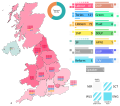
English: The map shows the results of the election in the nine regions of England, as well as the nations of Scotland, Wales and Northern Ireland. The subdivisions are shaded according to the percentage of seats secured by the strongest party in that subdivision. To the right of the map there is a small bar chart showing the turnout, as well as a large legend detailing parties, their results as well as colors used for shading the map. Each party - except for the Speaker, who is a single individual - has four colored, striped or grey squares next to it. The squares denote each of the UK's four nations. Clockwise from the top right there are Scotland (SCT), England (ENG), Wales (WLs) and Northern Ireland (NIR). A colored square denotes that a party stood for the election in that nation and won at least one seat: a striped square denotes that it stood, but did not win a single seat, while a grey square denotes that it did not stand. The outlines of the regions and nations are taken from File:2019 UK general election, countries and regions.svg
Дата
Источник Собственная работа
Автор MapperGuy87

Лицензирование

Я, владелец авторских прав на это произведение, добровольно публикую его на условиях следующей лицензии:
Creative Commons CC-Zero Этот файл доступен на условиях Creative Commons CC0 1.0 Универсальной передачи в общественное достояние (Universal Public Domain Dedication).
Лица, связанные с работой над этим произведением, решили передать данное произведение в общественное достояние, отказавшись от всех прав на произведение по всему миру в рамках закона об авторских правах (а также связанных и смежных прав), в той степени, которую допускает закон. Вы можете копировать, изменять, распространять, исполнять данное произведение в любых целях, в том числе в коммерческих, без получения на это разрешения автора.

Краткие подписи

Добавьте однострочное описание того, что собой представляет этот файл
The results of the 2024 UK general election by region and nation

Элементы, изображённые на этом файле

изображённый объект

У этого свойства есть некоторое значение без элемента в

image/svg+xml

История файла

Нажмите на дату/время, чтобы посмотреть файл, который был загружен в тот момент.

Дата/времяМиниатюраРазмерыУчастникПримечание
текущий09:54, 11 июля 2024Миниатюра для версии от 09:54, 11 июля 20241312 × 1157 (2,31 МБ)MapperGuy87Changed the Plaid's color to a shade of green to be consistent with the Wales map.
15:28, 8 июля 2024Миниатюра для версии от 15:28, 8 июля 20241312 × 1157 (2,31 МБ)MapperGuy87Changed the UUP's color to a darker shade of blue, corrected a typo where the TUV was called the TUP.
21:46, 6 июля 2024Миниатюра для версии от 21:46, 6 июля 20241312 × 1157 (2,31 МБ)MapperGuy87Fixed an error where the Greens were shown to win at least one seat in Wales.
15:33, 6 июля 2024Миниатюра для версии от 15:33, 6 июля 20241312 × 1157 (2,31 МБ)MapperGuy87Uploaded own work with UploadWizard

Следующая страница использует этот файл:

Глобальное использование файла

Данный файл используется в следующих вики:

Метаданные