Файл:Aorounga Impact Crater, Chad.jpg
Исходный файл (1440 × 960 пкс, размер файла: 472 КБ, MIME-тип: image/jpeg)
Этот файл находится на Викискладе. Сведения о нём показаны ниже.
Викисклад — централизованное хранилище для свободных файлов, используемых в проектах Викимедиа.
|
Краткое описание
| Описание |
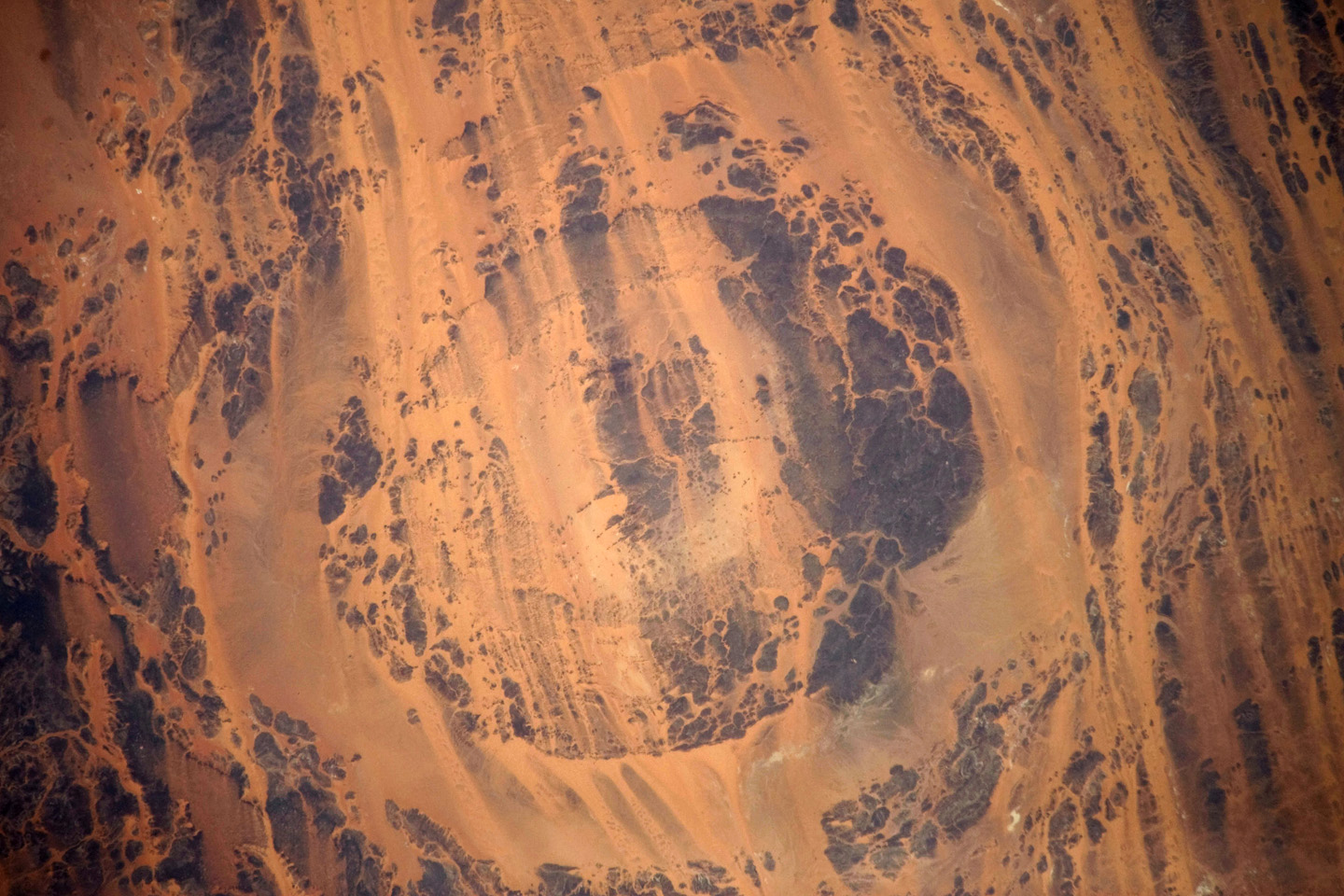
English: The concentric ring structure of the Aorounga crater—renamed Aorounga South in the multiple-crater interpretation of SIR data—is clearly visible in this detailed astronaut photograph. The central highland, or peak, of the crater is surrounded by a small sand-filled trough; this in turn is surrounded by a larger circular trough. Linear rock ridges alternating with light orange sand deposits cross the image from upper left to lower right; these are called yardangs by geomorphologists. Yardangs form by wind erosion of exposed rock layers in a unidirectional wind field. The wind blows from the north-east at Aorounga, and sand dunes formed between the yardangs are actively migrating to the south-west.
|
||||||||||||||||||||||||||||||||||||||||||||||||||||||
| Дата | |||||||||||||||||||||||||||||||||||||||||||||||||||||||
| Источник | NASA Earth Observatory | ||||||||||||||||||||||||||||||||||||||||||||||||||||||
| Автор |
|
||||||||||||||||||||||||||||||||||||||||||||||||||||||
| Другие версии |
|
||||||||||||||||||||||||||||||||||||||||||||||||||||||

Это изображение или видеозапись внесены в каталог Космического центра имени Джонсона НАСА под идентификатором (Photo ID): ISS020-E-026195. Этот шаблон не указывает на правовой статус данной работы. По-прежнему необходим нормальный шаблон лицензий. См. Commons:Лицензирование. Другие языки:
|
Image acquired with a Nikon D3 digital camera fitted with an 800 mm lens, and is provided by the ISS Crew Earth Observations experiment and Image Science & Analysis Laboratory, Johnson Space Centre.
Лицензирование
| Этот файл находится в общественном достоянии (англ. public domain), так как он был создан NASA (Национальным управлением по аэронавтике и исследованию космического пространства). Политика авторского права NASA гласит, что «Материал NASA не защищается авторским правом, если не указано иное». (См. Template:PD-USGov, страницу политики авторского права NASA или политику использования изображений JPL.) | ||
 |
Предупреждения:
|
История файла
Нажмите на дату/время, чтобы посмотреть файл, который был загружен в тот момент.
| Дата/время | Миниатюра | Размеры | Участник | Примечание | |
|---|---|---|---|---|---|
| текущий | 09:02, 10 августа 2009 | | 1440 × 960 (472 КБ) | Originalwana | {{Information |Description={{en|1=The concentric ring structure of the Aorounga crater—renamed Aorounga South in the multiple-crater interpretation of SIR data—is clearly visible in this detailed astronaut photograph. The central highland, or peak, of |
Использование файла
Следующая страница использует этот файл:
Глобальное использование файла
Данный файл используется в следующих вики:
- Использование в de.wikipedia.org
- Использование в en.wikipedia.org
- Использование в it.wikipedia.org
- Использование в kk.wikipedia.org
- Использование в lt.wikipedia.org
- Использование в ro.wikipedia.org
- Использование в zh.wikipedia.org