Перейти на страницу файла на Викискладе

Файл:Cyprus ESA356100.jpg

Материал из Википедии — свободной энциклопедии
Перейти к навигации Перейти к поиску

Исходный файл (10 000 × 7196 пкс, размер файла: 82,48 МБ, MIME-тип: image/jpeg)

Краткое описание

Внимание! Изображение содержит очень большое количество пикселей, и при просмотре его в полном разрешении в некоторых обозревателях могут возникнуть такие проблемы, как загрузка искажённого изображения или зависание. Помощник просмотра больших изображений
Описание
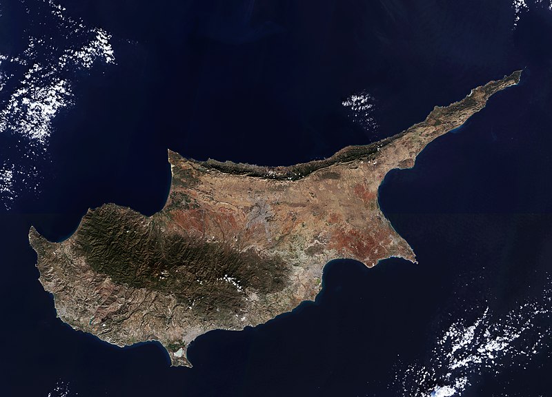
English: The third largest island in the Mediterranean, Cyprus is about 240 km long and 100 km wide. It is located on the Anatolian plate and therefore belongs geologically to Asia, but politically it is a member of the EU.

The Troodos mountains dominate the centre of the island and include Mount Olympus, the country’s highest mountain at 1952 m. Along the northern coast, the smaller Kyrenia Range rises suddenly from the plains. The capital and largest city, Nicosia, sits between the two mountain ranges. Since 1974 the island has been split between the Greek Cypriot and Turkish Cypriot populations, with the line of separation running through the city. East of Nicosia lies the Mesaoria plain, which is the agricultural heartland of the island – but depends greatly on winter rainfall and irrigation, limiting its production. High summer temperatures further exacerbate the situation. Thousands of years ago the area was covered by thick forest, but most of this was cut down to provide wood for the Ptolemaic dynasty’s navy in the 1st century BC. Today, much of the plain is covered by hard-packed calcium carbonate. At the southernmost area of Cyprus we can see the Limassol Salt Lake, the largest inland body of water on the island. Covering over 10 sq km, the lake is an important stopover for birds migrating between Africa and Europe, with greater flamingos spending the winter months there. Further up the coast to the east is the seasonal Larnaca Salt Lake, which also sees flamingos.

This image – also featured on theEarth from Space video programme– comprises two scans from the Sentinel-2A satellite on the same day: 22 December 2015. 
Дата
Источник http://www.esa.int/spaceinimages/Images/2016/03/Cyprus
Автор European Space Agency
Права
(Повторное использование этого файла)
Copernicus Sentinel data (2015)/ESA,CC BY-SA 3.0 IGO
Другие версии
Title
InfoField
Cyprus
Set
InfoField
Earth observation image of the week
System
InfoField
Copernicus
Mission
InfoField
Sentinel-2
Location
InfoField
Cyprus
Activity
InfoField
Observing the Earth
Keywords
InfoField
Satellite image; Islands; Coast; Coast line; Mountain

Лицензирование

w:ru:Creative Commons
атрибуция распространение на тех же условиях
Этот файл доступен по лицензии Creative Commons Attribution-Share Alike 3.0 IGO.
Вы можете свободно:
  • делиться произведением – копировать, распространять и передавать данное произведение
  • создавать производные – переделывать данное произведение
При соблюдении следующих условий:
  • атрибуция – Вы должны указать авторство, предоставить ссылку на лицензию и указать, внёс ли автор какие-либо изменения. Это можно сделать любым разумным способом, но не создавая впечатление, что лицензиат поддерживает вас или использование вами данного произведения.
  • распространение на тех же условиях – Если вы изменяете, преобразуете или создаёте иное произведение на основе данного, то обязаны использовать лицензию исходного произведения или лицензию, совместимую с исходной.
© This image contains data from a satellite in the Copernicus Programme, such as Sentinel-1, Sentinel-2 or Sentinel-3. Attribution is required when using this image.
Атрибуция: Contains modified Copernicus Sentinel data {{{year}}}

The use of Copernicus Sentinel Data is regulated under EU law (Commission Delegated Regulation (EU) No 1159/2013 and Regulation (EU) No 377/2014). Relevant excerpts:


Financial conditions

Free access shall be given to GMES dedicated data [...] made available through GMES dissemination platforms [...].

Conditions regarding use

Access to GMES dedicated data [...] shall be given for the purpose of the following use in so far as it is lawful:

  1. reproduction;
  2. distribution;
  3. communication to the public;
  4. adaptation, modification and combination with other data and information;
  5. any combination of points (a) to (d).

GMES dedicated data [...] may be used worldwide without limitations in time.

Conditions regarding information to be given by users
  1. When distributing or communicating GMES dedicated data [...] to the public, users shall inform the public of the source of that data and information.
  2. Users shall make sure not to convey the impression to the public that the user’s activities are officially endorsed by the Union.
  3. Where that data or information has been adapted or modified, the user shall clearly state this.
Absence of warranty

GMES dedicated data and GMES service information are provided to users without any express or implied warranty, including as regards quality and suitability for any purpose.

Краткие подписи

Добавьте однострочное описание того, что собой представляет этот файл

Элементы, изображённые на этом файле

изображённый объект

image/jpeg

86 483 957 байт

7196 пиксель

10 000 пиксель

История файла

Нажмите на дату/время, чтобы посмотреть файл, который был загружен в тот момент.

Дата/времяМиниатюраРазмерыУчастникПримечание
текущий11:12, 14 января 2021Миниатюра для версии от 11:12, 14 января 202110 000 × 7196 (82,48 МБ)StellarHalohigher resolution
20:27, 7 мая 2017Миниатюра для версии от 20:27, 7 мая 20171920 × 1382 (1,7 МБ)European Space Agency, Id 356100, http://www.esa.int/spaceinimages/Images/2016/03/Cyprus, User:Fæ/Project_list/ESA

Нет страниц, использующих этот файл.

Глобальное использование файла

Метаданные