Файл:Earth's City Lights by DMSP, 1994-1995 (medium).png
Исходный файл (2560 × 1280 пкс, размер файла: 2,56 МБ, MIME-тип: image/png)
Этот файл находится на Викискладе. Сведения о нём показаны ниже.
Викисклад — централизованное хранилище для свободных файлов, используемых в проектах Викимедиа.
|
Краткое описание
| Описание |
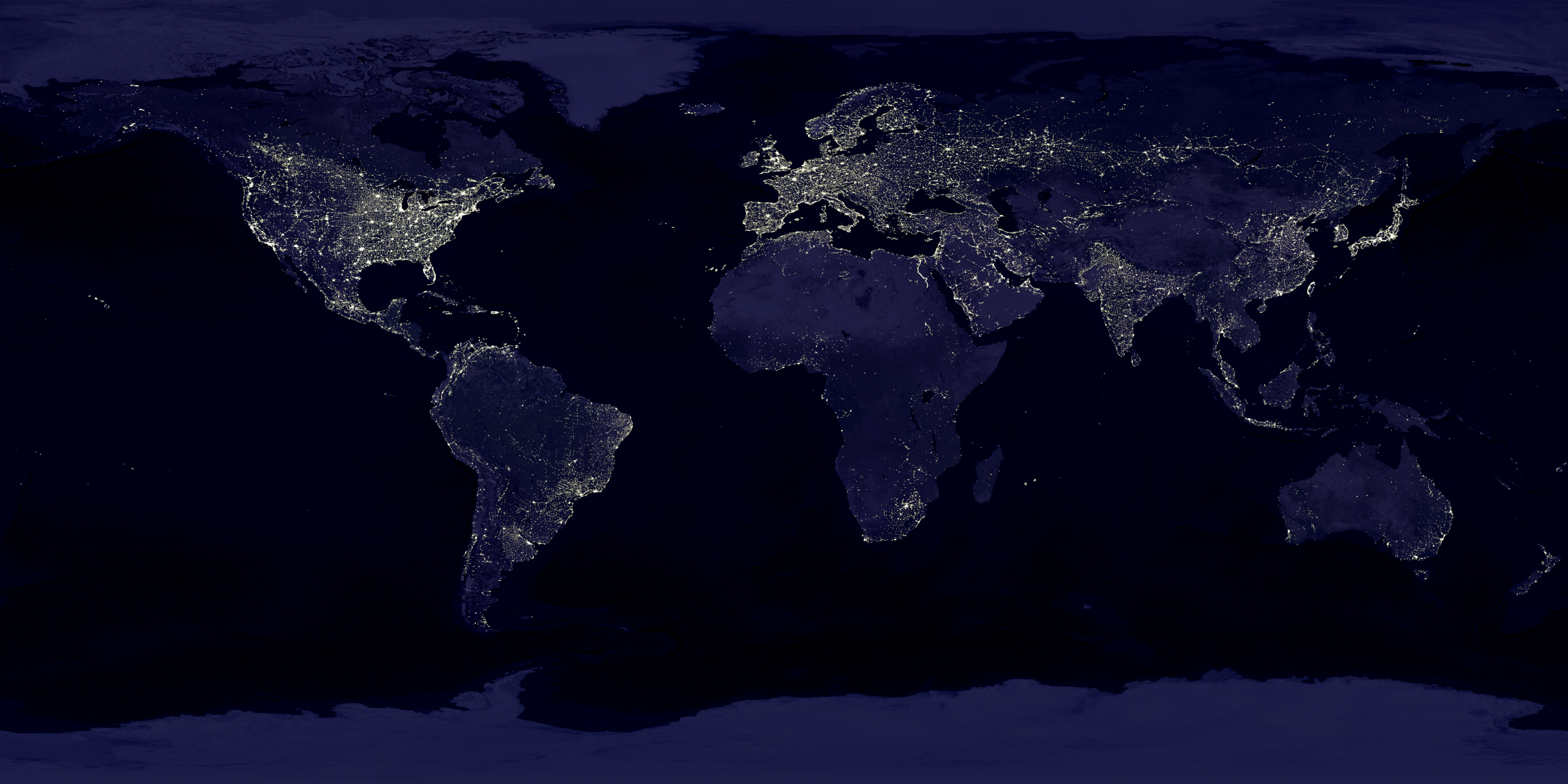
English: This image of Earth’s city lights was created with data from the Defense Meteorological Satellite Program (DMSP) Operational Linescan System (OLS). Originally designed to view clouds by moonlight, the OLS is also used to map the locations of permanent lights on the Earth’s surface.
The brightest areas of the Earth are the most urbanized, but not necessarily the most populated. (Compare western Europe with China and India.) Cities tend to grow along coastlines and transportation networks. Even without the underlying map, the outlines of many continents would still be visible. The United States interstate highway system appears as a lattice connecting the brighter dots of city centers. In Russia, the Trans-Siberian railroad is a thin line stretching from Moscow through the center of Asia to Vladivostok. The Nile River, from the Aswan Dam to the Mediterranean Sea, is another bright thread through an otherwise dark region. Even more than 100 years after the invention of the electric light, some regions remain thinly populated and unlit. Antarctica is entirely dark. The interior jungles of Africa and South America are mostly dark, but lights are beginning to appear there. Deserts in Africa, Arabia, Australia, Mongolia, and the United States are poorly lit as well (except along the coast), along with the boreal forests of Canada and Russia, and the great mountains of the Himalaya. |
| Дата | между 1 октябрём 1994 и 31 мартом 1995 |
| Источник | https://visibleearth.nasa.gov/view.php?id=55167 (image link) |
| Автор | Data: Marc Imhoff/NASA GSFC, Christopher Elvidge/NOAA NGDC; Image: Craig Mayhew and Robert Simmon/NASA GSFC |
| Другие версии |
|
.jpg)
.jpg)
.png)

.png?uselang=ru)
Лицензирование
| Этот файл находится в общественном достоянии (англ. public domain), так как он был создан NASA (Национальным управлением по аэронавтике и исследованию космического пространства). Политика авторского права NASA гласит, что «Материал NASA не защищается авторским правом, если не указано иное». (См. Template:PD-USGov, страницу политики авторского права NASA или политику использования изображений JPL.) | ||
 |
Предупреждения:
|
Это произведение находится в общественном достоянии, поскольку содержит материалы Национального управления океанических и атмосферных исследований США, полученные его сотрудниками в ходе выполнения должностных обязанностей.
|
История файла
Нажмите на дату/время, чтобы посмотреть файл, который был загружен в тот момент.
| Дата/время | Миниатюра | Размеры | Участник | Примечание | |
|---|---|---|---|---|---|
| текущий | 18:49, 15 апреля 2017 | | 2560 × 1280 (2,56 МБ) | Huntster | Standardise appearance in series. |
| 20:45, 9 марта 2009 |  | 2560 × 1364 (2,18 МБ) | Tryphon | Higher resolution. | |
| 15:05, 18 сентября 2007 |  | 1499 × 797 (658 КБ) | Jonathan Kovaciny~commonswiki | Re-cropped version of original NASA image. | |
| 15:03, 18 сентября 2007 |  | 1521 × 797 (667 КБ) | Jonathan Kovaciny~commonswiki | Cropped version of the original NASA image. | |
| 16:26, 30 марта 2007 |  | 1500 × 1125 (1,61 МБ) | Laur2ro | {{Information |Description=Earth lights, image is slightly edited (increased contrast and brightness; similar to Image:Whole world - at night.png, but the continents are visible also). |Source=http://visibleearth.nasa.gov/view_rec.php?id=11793 |Date=m |
Использование файла
Следующие 2 страницы используют этот файл:
Глобальное использование файла
Данный файл используется в следующих вики:
- Использование в ar.wikipedia.org
- Использование в ca.wikipedia.org
- Использование в en.wikipedia.org
- Использование в en.wikiquote.org
- Использование в en.wikiversity.org
- Использование в es.wikinews.org
- Использование в fr.wikipedia.org
- Использование в fr.wikiversity.org
- Использование в ha.wikipedia.org
- Использование в hi.wikipedia.org
- Использование в hr.wikipedia.org
- Использование в it.wikipedia.org
- Использование в mwl.wikipedia.org
- Использование в pl.wikipedia.org
- Использование в sh.wikipedia.org
- Использование в uk.wikipedia.org
- Использование в uz.wikipedia.org
- Использование в www.wikidata.org
.png)