Файл:India-Pakistan Border at Night.jpg

Исходный файл (4928 × 3280 пкс, размер файла: 5,3 МБ, MIME-тип: image/jpeg)
Этот файл находится на Викискладе. Сведения о нём показаны ниже.
Викисклад — централизованное хранилище для свободных файлов, используемых в проектах Викимедиа.
|
Краткое описание
| Описание |
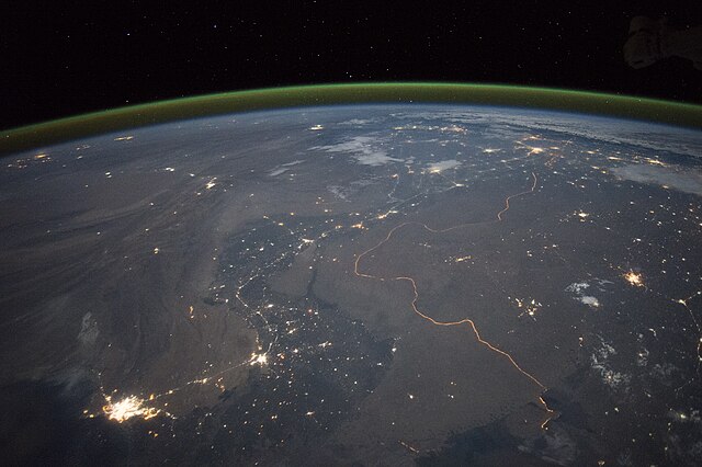
English: An astronaut aboard the International Space Station took this nighttime panorama while looking north across Pakistan’s Indus River valley. The port city of Karachi is the bright cluster of lights facing the Arabian Sea, which appears completely black. City lights and the dark color of dense agriculture closely track with the great curves of the Indus valley. For scale, the distance from Karachi to the foothills of the Himalaya Mountains is 1,160 kilometers (720 miles).
This photograph shows one of the few places on Earth where an international boundary can be seen at night. The winding border between Pakistan and India is lit by security lights that have a distinct orange tone. Another night image (click here) shows the border zone looking southeast from the Himalaya. A daylight view shows the vegetated bends of the Indus Valley winding through the otherwise desert country. More than two millennia ago, Alexander the Great entered the Indus plains in 327 BCE from the northwest. He then spent many months leading his army and navy down the length of the Indus valley shown in this view. From near Karachi, he then began the desert march back to Mesopotamia (modern Iraq). By contrast, it takes the space station just three minutes to travel this distance. |
| Дата | 23 сентября 2015, 17:15:48 GMT |
| Источник | NASA Earth Observatory |
| Автор | ISS Expedition 45 crew |
| Местоположение камеры | | Это и другие изображения по их местоположению на OpenStreetMap |
|---|
Это изображение или видеозапись внесены в каталог Космического центра имени Джонсона НАСА под идентификатором (Photo ID): ISS045-E-27869. Этот шаблон не указывает на правовой статус данной работы. По-прежнему необходим нормальный шаблон лицензий. См. Commons:Лицензирование. Другие языки:
|
Image acquired with a Nikon D4 digital camera using a 28 millimeter lens, and is provided by the ISS Crew Earth Observations Facility and the Earth Science and Remote Sensing Unit, Johnson Space Center.
Лицензирование
| Этот файл находится в общественном достоянии (англ. public domain), так как он был создан NASA (Национальным управлением по аэронавтике и исследованию космического пространства). Политика авторского права NASA гласит, что «Материал NASA не защищается авторским правом, если не указано иное». (См. Template:PD-USGov, страницу политики авторского права NASA или политику использования изображений JPL.) | ||
 |
Предупреждения:
|
История файла
Нажмите на дату/время, чтобы посмотреть файл, который был загружен в тот момент.
| Дата/время | Миниатюра | Размеры | Участник | Примечание | |
|---|---|---|---|---|---|
| текущий | 19:08, 5 октября 2015 | | 4928 × 3280 (5,3 МБ) | Udonknome | User created page with UploadWizard |
Использование файла
Следующая страница использует этот файл:
Глобальное использование файла
Данный файл используется в следующих вики:
- Использование в az.wikipedia.org
- Использование в bn.wikipedia.org
- Использование в ca.wikipedia.org
- Использование в de.wikipedia.org
- Использование в en.wikipedia.org
- Использование в fa.wikipedia.org
- Использование в fr.wikipedia.org
- Frontière entre l'Inde et le Pakistan
- Discussion:Frontière entre l'Inde et le Pakistan
- Relations entre l'Inde et le Pakistan
- Utilisateur:GhosterBot/BacASable/Le saviez-vous ?/Archives
- Wikipédia:Le saviez-vous ?/Archives/2023
- Wikipédia:Statistiques des anecdotes de la page d'accueil/Visibilité des anecdotes (2023)
- Discussion:Frontière entre l'Inde et le Pakistan/LSV 22562
- Wikipédia:Statistiques des anecdotes de la page d'accueil/Visibilité des anecdotes (2023)/2023 09
- Использование в hif.wikipedia.org
- Использование в hi.wikipedia.org
- Использование в it.wikipedia.org
- Использование в ja.wikipedia.org
- Использование в kn.wikipedia.org
- Использование в pa.wikipedia.org
- Использование в pnb.wikipedia.org
- Использование в te.wikipedia.org
- Использование в tr.wikipedia.org
- Использование в vi.wikipedia.org