Файл:Isle of Angleseymap 1946.jpg
Перейти к навигации
Перейти к поиску

Размер этого предпросмотра: 737 × 600 пкс. Другие разрешения: 295 × 240 пкс | 590 × 480 пкс | 944 × 768 пкс | 1259 × 1024 пкс | 2517 × 2048 пкс | 4747 × 3862 пкс.
Исходный файл (4747 × 3862 пкс, размер файла: 4,73 Мб, MIME-тип: image/jpeg)
Этот файл находится на Викискладе. Сведения о нём показаны ниже.
Викисклад — централизованное хранилище для свободных файлов, используемых в проектах Викимедиа.
|
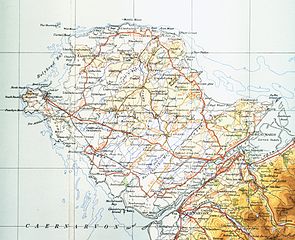
| Описание | Map of Isle of Anglesey from 1946. Scale 0.25 inch to the mile 600DPI Sheet 4 "north wales and manchester" fourth edition |
| Дата | |
| Источник | OS Sheet 4 "north wales and manchester" fourth edition |
| Автор | OS |
This work is an Ordnance Survey map over 50 years old, which is covered by Crown Copyright which in this case expires 50 years after publication. Ordnance Survey does however ask that they be credited and that the date of publication be given.
Any ancillary rights gained through the creation of the electronic version are granted as freely usable under any circumstances.
|
Это художественное произведение, созданное Правительством Соединённого Королевства Великобритании и Северной Ирландии, находится в общественном достоянии (англ. public domain)
по одной из следующих причин:
Канцелярия Её Величества (HMSO) заявила, что истечение Авторских прав, принадлежащих Короне (англ. Crown copyright), происходит по всему миру (справка: ответ HMSO на сообщение электронной почты)
|
 |
История файла
Нажмите на дату/время, чтобы посмотреть файл, который был загружен в тот момент.
| Дата/время | Миниатюра | Размеры | Участник | Примечание | |
|---|---|---|---|---|---|
| текущий | 16:10, 17 ноября 2009 | | 4747 × 3862 (4,73 Мб) | Lirion | slight colour improvements |
| 19:11, 9 мая 2009 |  | 4747 × 3862 (4,28 Мб) | Geni | {{Information |Description=Map of Isle of Anglesey from 1946. Scale 0.25 inch to the mile 600DPI Sheet 4 "north wales and manchester" fourth edition |Source=OS Sheet 4 "north wales and manchester" fourth edition |Date=1954 |Author=OS |Permission=none need |
Использование файла
Следующая страница использует этот файл:
Глобальное использование файла
Данный файл используется в следующих вики:
- Использование в cy.wikipedia.org
- Использование в de.wikipedia.org
- Использование в es.wikipedia.org
- Использование в hsb.wikipedia.org
- Использование в hu.wikipedia.org
- Использование в sv.wikipedia.org