Файл:OsageTrail Independence Topo 1980red.JPG
Перейти к навигации
Перейти к поиску

Размер этого предпросмотра: 564 × 600 пкс. Другие разрешения: 226 × 240 пкс | 452 × 480 пкс | 722 × 768 пкс | 963 × 1024 пкс | 1927 × 2048 пкс | 3188 × 3389 пкс.
Исходный файл (3188 × 3389 пкс, размер файла: 3,07 МБ, MIME-тип: image/jpeg)
Этот файл находится на Викискладе. Сведения о нём показаны ниже.
Викисклад — централизованное хранилище для свободных файлов, используемых в проектах Викимедиа.
|
Краткое описание
| Описание |
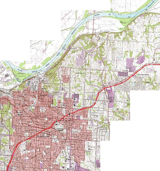
English: Topographical map of much of Independence, Missouri, showing roughly the route of the ancient "Great Osage [Indian] Trail" through the region. The trail originates near central Missouri, Boonville and Franklin, Missouri, followed the route of modern U.S. 24 highway, and portions of modern Lexington Street and Westport Road in Independence, Missouri (the curved portions of each street in modern Independence, Missouri). |
| Дата | |
| Источник | United States Geological Survey maps (public domain) at "TerraServer USA", USGS in cooperation with Microsoft via msrmaps.com, composite map is from USGS map "Independence, Missouri, United States 7/1/1995" |
| Автор | I patch-worked together USGS sectional maps of the region online, such as the segment shown at http://preview.tinyurl.com/339hlmv, and added the blurry red line with MS (Microsoft) "Paint". While the maps are dated "7/1/1995", the data was originally collected and published in 1980. |
The illustration (map) and explanations of it can be revised and enhanced as further research takes place.
Лицензирование
Это изображение находится в общественном достоянии, так как содержит материалы, которые первоначально получены от Геологической службы США (USGS) — агентства Министерства внутренних дел США. Дополнительную информацию см. «Официальная политика авторского права USGS» (англ.).
|
История файла
Нажмите на дату/время, чтобы посмотреть файл, который был загружен в тот момент.
| Дата/время | Миниатюра | Размеры | Участник | Примечание | |
|---|---|---|---|---|---|
| текущий | 05:52, 7 августа 2010 | | 3188 × 3389 (3,07 МБ) | EGDJ | {{Information |Description={{en|1=Topographical map of much of Independence, Missouri, showing roughly the route of the ancient "Great Osage [Indian] Trail" through the region. The trail originates near central Missouri, Boonville and Franklin, Missouri, |
Использование файла
Нет страниц, использующих этот файл.
Глобальное использование файла
Данный файл используется в следующих вики:
- Использование в en.wikipedia.org