Файл:PIA05484 modest.jpg
Исходный файл (1278 × 352 пкс, размер файла: 40 КБ, MIME-тип: image/jpeg)
Этот файл находится на Викискладе. Сведения о нём показаны ниже.
Викисклад — централизованное хранилище для свободных файлов, используемых в проектах Викимедиа.
|
Краткое описание
| Описание |
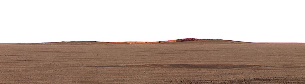
English: This image taken by the Mars Exploration Rover Opportunity's panoramic camera shows the eastern plains that stretch beyond the small crater where the rover landed. In the distance, the rim of a larger crater dubbed "Endurance" can be seen.
This color mosaic was taken on the 32nd martian day, or sol, of the rover's mission and spans 20 degrees of the horizon. It was taken while Opportunity was parked at the north end of the outcrop, in front of the rock region dubbed "El Capitan" and facing east. The features seen at the horizon are the near and far rims of "Endurance," the largest crater within about 6 kilometers (4 miles) of the lander. Using orbital data from the Mars Orbiter Camera on NASA's Mars Global Surveyor spacecraft, scientists estimated the crater to be 160 meters (175 yards) in diameter, and about 720 meters (half a mile) away from the lander. The highest point visible on "Endurance" is the highest point on the far wall of the crater; the sun is illuminating the inside of the far wall. Between the location where the image was taken at "El Capitan" and "Endurance" are the flat, smooth Meridiani plains, which scientists believe are blanketed in the iron-bearing mineral called hematite. The dark horizontal feature near the bottom of the picture is a small, five-meter (16-feet) crater, only 50 meters (164 feet) from Opportunity's present position. When the rover leaves the crater some 2 to 3 weeks from now, "Endurance" is one of several potential destinations. |
| Дата | |
| Источник | http://photojournal.jpl.nasa.gov/catalog/PIA05484 |
| Автор | NASA/JPL/Cornell/MSSS |
Это изображение или видеозапись внесены в каталог Лаборатории реактивного движения НАСА под идентификатором (Photo ID): PIA05484. Этот шаблон не указывает на правовой статус данной работы. По-прежнему необходим нормальный шаблон лицензий. См. Commons:Лицензирование. Другие языки:
|
Лицензирование
| Этот файл находится в общественном достоянии (англ. public domain), так как он был создан NASA (Национальным управлением по аэронавтике и исследованию космического пространства). Политика авторского права NASA гласит, что «Материал NASA не защищается авторским правом, если не указано иное». (См. Template:PD-USGov, страницу политики авторского права NASA или политику использования изображений JPL.) | ||
 |
Предупреждения:
|
Исходный журнал загрузок
- 2004-03-02 23:38 Perl 1100×303× (28911 bytes) This image taken by the Mars Exploration Rover Opportunity's panoramic camera shows the eastern plains that stretch beyond the small crater where the rover landed. In the distance, the rim of a larger crater dubbed "Endurance" can be seen. This color m
История файла
Нажмите на дату/время, чтобы посмотреть файл, который был загружен в тот момент.
| Дата/время | Миниатюра | Размеры | Участник | Примечание | |
|---|---|---|---|---|---|
| текущий | 04:53, 17 февраля 2013 | 1278 × 352 (40 КБ) | Huntster | Full size from original source. | |
| 22:51, 28 мая 2009 | 1100 × 303 (28 КБ) | File Upload Bot (Magnus Manske) | {{BotMoveToCommons|en.wikipedia|year={{subst:CURRENTYEAR}}|month={{subst:CURRENTMONTHNAME}}|day={{subst:CURRENTDAY}}}} {{Information |Description={{en|This image taken by the Mars Exploration Rover Opportunity's panoramic camera shows the eastern plains |
Использование файла
Следующая страница использует этот файл:
Глобальное использование файла
Данный файл используется в следующих вики:
- Использование в en.wikipedia.org
- Использование в fa.wikipedia.org
- Использование в fr.wikipedia.org
- Использование в hr.wikipedia.org
- Использование в ja.wikipedia.org
- Использование в no.wikipedia.org
- Использование в sv.wikipedia.org
- Использование в uk.wikipedia.org
- Использование в zh.wikipedia.org